
 United Kingdom
 France
 Germany
 Netherlands
 Sweden
 USA
USA
 Italy
Italy
 Spain
Spain
More From Contributor


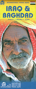
Iraq & Baghdad ITMB
Iraq and Baghdad at 1:1, 200, 000 and 1: 25, 000 respectively, on a double-sided, indexed road map from ITMB including insets of Baghdad Environs and Mesopotamia. The map displays Iraq on one side and Baghdad on the other, each featuring a separate index. Road networks shown include motorways and highways, main and secondary roads as well as minor roads. Railways, international and local airports are also located. Topography is represented by altitude colouring and graphics indicate deserts, swamps, rivers, lakes, etc. Symbols mark locations of various places of interest including historic ruins, monuments, Unesco World Heritage Sites, mosques, castles and churches, oil fields etc. Provincial, international boundaries and border crossing are marked. The street plan of
Baghdad extends in the north to the Tigris River at the height of the Kadhimya and the Iraqi Department Store to the Jazair and Dora districts in the south, in the east it reaches New Baghdad and Khansa district and in the west the Andalus and Huriya districts including the Ancient Round City. Clearly shown are the expressways, primary, secondary and minor roads. Streets are shown but only the main ones are named. Railway lines are marked and the main stations named. Colouring distinguishes the Old City, built-up and development areas, parks, public buildings and military complexes. Information for the visitor includes parking, gas stations and bus terminals, palaces and mosques, museums and monuments, tourist information points, embassies, banks, hotels and restaurants and
shopping centres, etc.A separate enlargement represents Baghdad’s environs at 1:850, 000 stretching to Kirkuk in the north and Razzazah Lake in the south, Ar-Ramadi in the west and the Iran border in the east. In this inset, additional details like road numbers and intermediate distances on major roads supplement the information provided for the main country map as described above. Topography is enhanced with contour heights in metres and spots elevation. Further geographical features include irrigation canals, swamps, seasonal rivers and salt hollows, oil, gas and water pipelines and oil wells and many places of interest. Latitude and longitude lines are drawn at intervals of 1º.One small inset shows a reference map of Mesopotamia at 1:4, 000, 000, its regions and the major
cities.The map is annotated with historical and tourist information of places of interest and is indexed, all place names are shown transliterated only. The main country map does not have geographical coordinates.

Product Description
Reviews/Comments
Add New
Vouchers
No voucher codes found.
Do you know a voucher code for this product or supplier? Add it to Insights for others to use.
Do you know a voucher code for this product or supplier? Add it to Insights for others to use.
 Denmark