
 United Kingdom
 France
 Germany
 Netherlands
 Sweden
 USA
USA
 Italy
Italy
 Spain
Spain
More From Contributor


Ipswich 1902
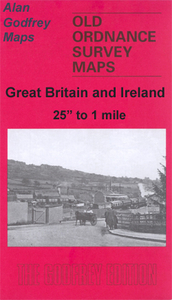
Ipswich in 1902 in a fascinating series of reproductions of old Ordnance Survey plans in the Alan Godfrey Editions, ideal for anyone interested in the history of their neighbourhood or family. Ipswich is covered by four maps. This title, IPSWICH, covers much of the town centre, extending from Hanford Hall and Hanford Bridge eastward to the Shire Hall and the prison, and from Chevalier Street and Ivry Street southward to the Goods station and Stoke Bridge. Features include New Cattle Market, St Matthew`s church, St Clement`s church, Butter Market, Commercial Road, St Peter`s Wharf, River Orwell, St Mary at the Tower church, Lower Ramparts St Peter`s church; Old Cattle Market with part of the Wet Dock is in the south-eastern corner. The directory on the back lists inhabitants A
to G. IPSWICH EAST takes coverage further east and includes the area known as California, which was clearly being developed at the time of the map. Features include the Workhouse, Cauldwell Hall, St Helen`s Street, Spring Road, Woodbridge Road, Foxhall Road, Holy Trinity church, etc. The Borough Asylum and Derby Road station are both partly in the bottom margin (and continued on the South-East map). The directory of private residents continues with entries G to R. IPSWICH SOUTH-WEST covers an area from the station and St Mary`s church a mile south to Halifax Works and Stoke Park. Features include the New Cut, Waterside Works, Stoke Hill, engine shed, Wherstead Road, Belstead Road, etc. On the reverse is a large extract from the GER London-Norwich timetable of 1915. IPSWICH
SOUTH-EAST completes the quartet and covers an area from Eagle Wharf and Ransome`s Wharf eastward one and a half miles along the Felixstowe Road. Features include Cliff Brewery, Holywells, St Clements Shipyard. On the reverse the directory is completed with entries R to Z. About the Alan Godfrey Editions of the 25” OS Series:Selected towns in Great Britain and Ireland are covered by maps showing the extent of urban development in the last decades of the 19th and early 20th century. The plans have been taken from the Ordnance Survey mapping and reprinted at about 15 inches to one mile (1:4, 340). On the reverse most maps have historical notes and many also include extracts from contemporary directories. Most maps cover about one mile (1.6kms) north/south, one and a half miles (2.4kms)
across; adjoining sheets can be combined to provide wider coverage.FOR MORE INFORMATION AND A COMPLETE LIST OF ALL AVAILABLE TITLES PLEASE CLICK ON THE SERIES LINK.

Product Description
Reviews/Comments
Add New
Intelligent Comparison
Archived Product

Ipswich East 1902 Stanfords
£3.50
Archived Product

Bloxwich 1902 Stanfords
£3.50
Vouchers
No voucher codes found.
Do you know a voucher code for this product or supplier? Add it to Insights for others to use.
Do you know a voucher code for this product or supplier? Add it to Insights for others to use.
 Denmark