More From Contributor
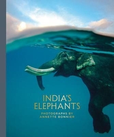
£30.00
Detailed physical wall map of Indiana State at a scale of 1:500, 000. The cartography shows relief through a stunning, highly ...
Archived Product
£7.99
Indianapolis & Vicinity in a series of Rand Mc Nally’s regional road maps covering the environs of main US cities. The map is centered on Indianapolis & extends north to Kokomo & West Lafayette, east to beyond Yorktown, south beyond Columbus, & westwards to Brazil & Hillsboro. Communities covered by this map include Anderson, Bloomington, Crawfordsville, Greenwood, Lawrence, Muncie, Plainfield & Shelbyville. Maps in this series present the road network on a clear background with no relief shading to show the area’s topography, but with national or state parks, forests & other protected areas indicated by colouring. Roads are numbered and/or named, showing toll highways, exit numbers of interchanges, services & rest areas. Local airports are marked, but railways & other urban transport lines are not included unless specifically indicated in the individual description. Each town is presented in a different colour, providing those unfamiliar with the region a very clear picture of the area. Various places of interest & facilities are highlighted, including cultural & historical sites, educational institutions, sport & recreational facilities, etc. Each title is indexed. Several maps also include enlargements of the downtown area, plans of international airports, a mileage & driving times diagram for a much wider region than covered by the main map, etc
- for more information please see the individual descriptions. To see all the titles in this series please click on the series link.
...
Archived Product
£7.99
Indianapolis in Indiana on an indexed street plan from Rand Mc Nally in their extensive range of maps covering cities in the United States. The map

Includes::
a more detailed enlargement of downtown Indianapolis. Other communities covered by this title include Beech Grove, Brownsburg, Carmel, Fishers, Greenwood, Lawrence, Noblesville, Southport, Speedway, Westfield & Zionsville.NEW STREET PLAN CARTOGRAPHY FROM RAND Mc NALLY: Rand Mc Nally are currently changing the cartography of their street plans to a more “ European” style. In many titles streets are now shown by parallel lines, providing a much clearer, easier to read presentation. Better use of colouring indicates different types of land use and/or institutions (parks, shopping centres, academic institutions, etc) &, in most titles, different administrative units. More streets are annotated with block numbers. Some new editions still retain the traditional American presentation of streets by a single line, but with more prominent marking for various institutions, facilities & places of interest. Our cartography sample indicates which style is used in this title.COVERAGE: Rand Mc Nally street plans cover cities with their outer suburbs, prominently highlighting principal traffic arteries & connecting main streets. Railway & subway stations are marked.

...
Archived Product
£6.50
Indianapolis in Indiana on an indexed street plan from Rand Mc Nally in their extensive range of maps covering cities in the United States. The map

Includes::
a more detailed enlargement of downtown Indianapolis, plus insets covering Brownsburg & Plainfield. Other communities covered by this title include Beech Grove, Carmel, Fishers, Greenwood, Lawrence, Southport, Speedway & Zionsville. Rand Mc Nally street plans provide coverage of cities with their outer suburbs, clearly indicating main traffic arteries: highways (distinguishing between free & toll access), plus primary & secondary routes. Road numbers and/or names are clearly displayed & exit numbers are indicated. Locations of service & rest areas are marked & one way streets are shown. Longer streets are annotated with block numbers for easier identification of addresses. The maps show railway, bus &, where appropriate, metro stations. A range of symbols indicate various places of interest including cultural & academic institutions, various municipal facilities, golf courses, etc. The plans have extensive street indexes, supplemented by lists of points of interest, parks & recreational areas, shopping malls, stations, schools, etc.

...
Archived Product
£30.00
India`s Disappearing Railways is a vibrant photo-essay by Australian photographer Angus Mc Donald, capturing for the first time in print the sub-continent`s unique narrow-gauge hill railways in all their vivid colour, character & chaos. It is an intimate & humorous portrait of life on the trains, evoking the very soul of India; & with a rare empathy & insight illustrates the lives of those who ride them, who work on them, & who live alongside them. Yet as the nation modernises, these railways
- whether in the snow-peaked Himalaya, the terai of Rajasthan or the verdant Nilgiri Hills of Tamil Nadu
- are vanishing. India`s Disappearing Railyways records a way of life that is slowly disappearing
- the Indian government is gradually converting its narrow-gauge lines
- & documents the diversity of this vast & multilayered country from a unique standpoint.


...
Archived Product
£12.99
Sir Mark Tully, born in India & educated in Britain, is a citizen of two countries
- indeed, two continents
- & two cultures.

...
Archived Product
£12.99
SPECTATOR BOOKS OF THE YEAR 2016, GUARDIAN BOOKS OF THE YEAR 2016 ` Authoritative, expansive & incisive...helps restore India to the global twentieth century` Sunil Khilnani Between 1939 & 1945 India changed to an extraordinary extent. Millions of Indians suddenly found themselves as soldiers, fighting in Europe & North Africa but also
- something simply never imagined
- against a Japanese army threatening to invade eastern India. Many more were pulled into the vortex of wartime mobilization. Srinath Raghavan`s compelling & original book gives both a surprising new account of the fighting & of life on the home front. For Indian nationalists the war has tended to be seen as a distraction from the quest for national independence
- but Raghavan shows that in fact the war lay at the very heart of how & why colonial rule ended in South Asia. By seeing the Second World War through Indian eyes, Raghavan transforms our understanding of the conflict
- with famous battles such as those in North Africa & Iraq reinterpreted, as well as fascinating & little known campaigns such as the destruction of Italian northeast Africa. Time & again, it was Indian troops that made Britain into a global power &, as the war came to an end, it was the Indian army that fought the final battles which marked the end both of the Japanese empire, & of the British.


...
Archived Product
£30.00
This extraordinary selection of objects showcases the beauty & knowledge embodied in works of art & everyday life from Indigenous Australia. Published to accompany the first major UK exhibition on Indigenous Australia, this ground breaking new publication explores the profound impact & legacy of colonialism, the nature of collecting & the changing meaning of objects now in the collection of the British Museum. The encounters between Indigenous peoples & colonists were complex & nuanced, & contemporary Australian society is still dealing with this legacy, trying to transform or reconcile different worldviews. ...
Archived Product
£12.99
The Indigenous People Trail map at 1:75, 000 highlighting a trekking circuit in the less visited part of Nepal directly east of Kathmandu. The map is part of the Nepa Maps series which provides extensive coverage of trekking areas of Nepal on detailed contoured maps with trekking routes & hiking trails, huts & camp sites, local places of interest & other tourist information. The map covers an area directly east of Kathmandu, with Dhulikhel & Khopasi at its western edge & Charikot in the north-eastern corner. Numerous trails are marked, with the main highlighted route crossing the area east of the Sunkashi River. Contours are at 80m intervals, with additional vegetation colouring. Margin ticks show latitude & longitude at intervals of 5`. The map is indexed &

Includes::
additional information on various stages of the main trek & other activities in this area. Titles in this series have cartography is based on the country’s topographic survey, with contours usually at 40m or 50m intervals, enhanced by relief shading, colouring & graphics to show various features of the terrain, including glaciers, forested or cultivated areas, etc. Numerous peaks, with additional spot heights, plus names of glaciers & mountain ranges are prominently shown. The network of rivers, streams & lakes is shown in great detail, with many smaller rivers & lakes named. Overprint highlights main trekking routes & numerous local trails, with symbols indicating various places of interest & tourist facilities. Most maps are indexed & include additional information such as route profiles, glossaries, etc. All the information is in English & heights are given in metres.

...
Archived Product
£8.99
Indigo is the rich, electrifying history of a precious dye: its relationship to the trans-Atlantic slave trade, its profound influence on fashion, & its spiritual significance
- all very much alive today. But it is also the story of a personal quest: Catherine Mc Kinley`s ancestors include a clan of Scots who wore indigo tartan, several generations of Jewish `rag traders` & Massachusetts textile factory owners, & African slaves who were traded along the same Saharan routes as indigo. Her journey takes her to nine West African countries & is resplendent with powerful lessons of heritage & history which shape the way she understands her world at home.
...
Archived Product

India`s Elephants

Annette Bonnier traveled throughout India over a 3 year period photographing the lives of domesticated and wild elephants. These photographs are a cultural documentation of this complex and majestic animal, with its intelligence, intricte social hierarchy, and highly evolved communication skills, and is caught in a changing world between the past and the future.
RIP - This product is no longer available on our network. It was last seen on 25.09.2019

This page now acts as a permanent archive for this product. Add more information using the comments box below to ensure it can still be found by future generations.

Use our search facility to see if it is available from an alternative contributor.
  • External links may include paid for promotion
  • Availability: Out Of Stock
  • Supplier: Stanfords
  • SKU: 9780983937883
Availability: In Stock
£50.00

Product Description

Annette Bonnier traveled throughout India over a 3 year period photographing the lives of domesticated & wild elephants. These photographs are a cultural documentation of this complex & majestic animal, with its intelligence, intricte social hierarchy, & highly evolved communication skills, & is caught in a changing world between the past & the future.

Reviews/Comments

Add New

Intelligent Comparison

Oooops!
We couldn't find anything!
Perhaps this product's unique.... Or perhaps we are still looking for comparisons!
Click to bump this page and we'll hurry up.

Price History

Vouchers

No voucher codes found.
Do you know a voucher code for this product or supplier? Add it to Insights for others to use.

Facebook

Jargon Buster

India - A subcontinent in Asia
World - A physical grouping, commonly used to describe earth and everything associated with ti
Year - The time it takes the planet earth to orbit the sun. This takes around 365.25 days.
Year - 365 days (366 days in a leap year), the time taken for planet earth to make one full revolution around the sun.

Supplier Information

Stanfords
Stanfords was established in 1853 and opened their iconic Covent Garden flagship store in 1901. They have become the top retailer of maps, travel books and accessories in the UK and arguably offer the largest selection of maps and travel books worldwide. Famous names such as Captain Robert Falcon Scott, Ranulph Fiennes and Michael Palin have purchased from Stanfords. They now have a shop in Bristol and both stores together with other venues operate a calendar of events including talks, book signings and exhibitions. As a specialist map retailer, the map selection is comprehensive and includes road maps, street maps and walking maps from worldwide destinations, as well as a selection of world atlases and wall maps. Books include travel guides and travel literature. Stanfords also stock globes, from miniatures made of blue marble to magnificent floor-standing globes. The website features a selection of interesting articles on travel topics.
Page Updated: 2023-11-12 20:15:36

Community Generated Product Tags

Oh No! The productWIKI community hasn't generated any tags for this product yet!
Menu