More From Contributor

£9.99
North-Eastern India at 1:1, 400, 000 approx. in a series of Adventure maps from the National Geographic Society with cartography provided by Reise Know-How. The map is double-sided & printed on light waterproof & tear-resistant plastic paper. Coverage

Includes::
the whole of Bangladesh & extends south to the northern part of Andhra Pradesh & west to Lucknow & Kanpur. Cartographic information provided by Reise Know-How has been adjusted to follow the house style of the NGS Adventure series with greater emphasis on the country’s topography. Altitude colouring in broader bands has been replaced here by contours at 200m intervals plus relief shading. National parks & other protected areas are highlighted. Road network

Includes::
selected local tracks & gives distances on main & some secondary or local routes. Railway lines are included & local airports are marked. Internal administrative boundaries are shown with names of the states. Symbols highlight various places of interest including UNESCO world heritage sites, archaeological remains, temples & museums, viewpoints, beaches, etc. Latitude & longitude lines are drawn at 1° intervals & the map has an index of place names. Overall, the slightly smaller scale of the NGS map & the presentation of the road & rail networks make the original Reise Know-How edition far clearer than the NGS map.PLEASE NOTE: to ensure regular supplies & faster delivery to our customers we keep as regular stock the Reise Know-How edition whilst the NGS version can be ordered on request.


...
Archived Product
£7.95
The north-eastern states of India including Assam & Sikkim, with Bangladesh & Bhutan, at 1:1, 500, 000 in a series of five double-sided maps from Nelles, with their slightly smaller size offering a convenient format for use when travelling. The maps present the country ...
Archived Product
£11.50
North-eastern India at 1:1, 300, 000 on a light, waterproof & tear-resistant, indexed road map from Reise Know-How with topographic & tourist information. The map, part of the publishers’ highly acclaimed World Mapping Project, is double-sided to provide the best balance between a good scale & a convenient size sheet, &

Includes::
Kolkata on both sides. Coverage extends west to Lucknow & Kanpur, south along the coast to Kakinada, north to include eastern Nepal with Kathmandu & Pokhara & south-eastern Tibet with Lhasa, plus the whole of Bangladesh & Bhutan. Topography is presented by altitude colouring with spot heights & names of mountain ranges, peaks & valleys, plus graphics for swamps, salt pans, etc. Road network

Includes::
selected local roads & tracks, indicating driving distances on main routes. Railway lines are included & local airports are marked. National parks & other protected areas are highlighted, & symbols show locations of various UNESCO sites, forts & palaces, temples & other religious buildings, natural curiosities, beaches, etc. The map has a latitude & longitude grid at intervals of 1° & an index of place names. Map legend

Includes::
English. To see coverage of India on other regional maps from Reise Know-How please click on the series link.


...
Archived Product
£13.99
Northeast India is a region off the usual tourist route, yet it contains some of the country's most beautiful scenery, remarkable religious monuments & vibrant cultural centres. Footprint's new guide, the first of its kind to this little-known part of the sub-continent, takes you to the Orissan temples of Puri, Bhubaneswar & Konark, the interior of Bihar & Jharkh&, where some tribal societies are only just being brought into contact with the modern world, & the mighty peaks of the Himalaya to the north, with Kangchendzonga towering over Sikkim & the northern hill stations of West Bengal. ...
Archived Product
£11.50
North-western India at 1:1, 300, 000 on a light, waterproof & tear-resistant, indexed road map from Reise Know-How with topographic & tourist information. The map, part of the publishers’ highly acclaimed World Mapping Project, is double-sided to provide the best balance between a good scale & a convenient size sheet. Coverage on the northern side extends beyond the demarcation border to K2 &

Includes::
Islamabad & most of the Pakistani part of Punjab; the southern side extends south to Daman & east to Jabalpur. Topography is presented by altitude colouring with spot heights & names of mountain ranges, peaks & valleys, plus graphics for swamps, salt pans, etc. Road network

Includes::
selected local roads & tracks, indicating driving distances on main routes. Railway lines are included & local airports are marked. National parks & other protected areas are highlighted, & symbols show locations of various UNESCO sites, forts & palaces, temples & other religious buildings, natural curiosities, beaches, etc. The map has a latitude & longitude grid at intervals of 1° & an index of place names. Map legend

Includes::
English. To see coverage of India on other regional maps from Reise Know-How please click on the series link.


...
Archived Product
£9.99
India is an exceptional destination for travellers whatever their interests & for those who love to observe & photograph nature & wildlife, it is a veritable treasure trove. For this volume of the Safari Companion series, the authors have explored the national parks & reserves of the north to capture, on film, life of the native animals & birds. In particular, the habitats of the tiger, that most magnificent feline of which tales & myths abound.. As with all titles in the series, the authors set out to share their field experiences, giving advice to add to the enjoyment of exploring the nature & wildlife of the country. Where appropriate, each picture is linked to a caption explaining the circumstances of the shoot & offering practical photographic advice. In a series of eight colourful books, the authors set out to encourage the international traveller away from the annual sojourn on the poolside lounger towards never to be forgotten adventure holidays, in places where nature can still be enjoyed at first h&. In addition to offering beautiful professional photographic images that capture the spirit of the l&, they provide useful travel hints & guidance for the camera enthusiasts keen to produce their own safari albums. The first four titles published in English, South Africa, Namibia, Botswana & India are to be published in September 2006, with Kenya, Galapagos, Tanzania & Madagascar following in the first half of 2007. ...
Archived Product
£4.79
The Lonely Planet India Phrasebook is not only an extensive list of useful phrases, but also an ideal tool to start getting to grips with a language & beginning two-way communication. Containing excellent sections on language basics such as numbers, question phrases, dates, phrase construction, grammar & pronunciation, as well as containing concise but well-rounded two-way dictionaries, Lonely Planet phrasebooks enable you to quickly & confidently construct your own phrases in addition to those given. The given phrases cover all the essential travel & tourism categories such as transport, communications, business meetings & accommodation, as well as in-depth categories such as health, food & social interaction. The phrasebooks are designed to enable more than just simple question-answer communication, allowing the start of two-way conversations
- putting you comfortably on your way to learning the language & understanding its speakers. True to Lonely Planet
...
Archived Product
£6.99
India in the Pocket Guide series from Berlitz; a collection of handy, pocket-sized guides dedicated to an extensive range of cities, regions & countries worldwide. Written in narrative form, individual guides explore the history, main sights & attractions, food & drink, accommodation & local culture of the destination in detail. Each Berlitz pocket guide has a similar format, with colour-coded sections helping readers locate information quickly in addition to distinctive chapters exploring the city or region. An introduction outlines the destination for visitors & a section dedicated to 'A Brief History' actually explores the area in relative depth. A where to go chapter is organized by region & city & is written in prose form with references to individual sites highlighted in bold for clarity. There are also further suggestions on where & when to eat. Recommendations for leisure activities in the region, including sport, nightlife & shopping, are also provided & tailored accordingly for each destination. Handy travel tips are listed alphabetically in a dedicated section, providing practical guidance & helping visitors make the most of their stay. The main hotels, particularly for cities, are also listed in an accommodation section, offering a brief overview with approximate price bandings & relevant contact details. ...
Archived Product
£6.99
Berlitz Pocket Guide India is a concise, full-colour travel guide that combines lively text with vivid photography to highlight the very best of this beguiling country, from its exquisite temples & ancient citadels to teeming cities & peaceful backwaters. Discover the ancient sites of Hampi & Ladakh, visit the unforgettable city of Varanasi & gaze at one of the wonders of the world, the Taj Mahal
- the Where To Go chapter details all the key places to visit in India. Handy maps on the cover help you get around with ease. To inspire you, the book offers a rundown of the Top 10 Attractions in India, followed by an itinerary full of ideas to plan a Perfect Tour of the country. The What to Do chapter is a snapshot of things to do, such as hill trekking, wildlife spotting, watching a game of cricket, catching a Bollywood blockbuster & shopping for silks in the market. You'll also be armed with background information, including a brief history of India & an Eating Out chapter covering its spicy cuisine. There are carefully chosen listings of the best hotels, & an A-Z to equip you with all the practical information you will need.
...
Archived Product
£6.99
” Berlitz Pocket Guide India” is a concise, full-colour travel guide that combines lively text with vivid photography to highlight the very best of this beguiling country, from its exquisite temples & ancient citadels to teeming cities & peaceful backwaters. Discover the ancient sites of Hampi & Ladakh, visit the unforgettable city of Varanasi & gaze at one of the wonders of the world, the Taj Mahal
- the Where To Go chapter details all the key places to visit in India. Handy maps on the cover help you get around with ease. To inspire you, the book offers a rundown of the Top 10 Attractions in India, followed by an itinerary full of ideas to plan a Perfect Tour of the country. The What to Do chapter is a snapshot of things to do, such as hill trekking, wildlife spotting, watching a game of cricket, catching a Bollywood blockbuster & shopping for silks in the market. You`ll also be armed with background information, including a brief history of India & an Eating Out chapter covering its spicy cuisine. There are carefully chosen listings of the best hotels, & an A-Z to equip you with all the practical information you will need.
...
Archived Product

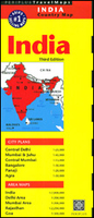
India Periplus Travel Map

Indian Subcontinent at 1:7, 000, 000 on an overview map from Periplus, accompanied by enlargements for some of its most visited areas: Rajastan, Goa, and the environs of Delhi and Mumbai, plus street plans of Delhi, Mumbai and Juhu, Panaji, Agra and Bangalore.The main map provides an overview of the Subcontinent, including most of Pakistan, Nepal, Bhutan, Bangladesh and most of Myanmar/Burma, showing the region’s main road and rail connections, plus within India the internal division into states. Some of India’s most visited areas are shown on separate enlargements: the environs of Delhi and Mumbai at 1:200, 000, Goa at 1:300, 000, plus Rajasthan at 1:2, 250, 000. The Goa map highlights numerous beaches along its coastline.Large street plans cover central districts of
Delhi, Mumbai extending north to the international airport in Juhu and with an enlargement of the city’s central area, plus Agra, Panaji and Bangalore. From all the maps and plans, only the Delhi plan is indexed.
RIP - This product is no longer available on our network. It was last seen on 25.09.2019

This page now acts as a permanent archive for this product. Add more information using the comments box below to ensure it can still be found by future generations.

Use our search facility to see if it is available from an alternative contributor.
  • External links may include paid for promotion
  • Availability: Out Of Stock
  • Supplier: Stanfords
  • SKU: 9780794607265
Availability: In Stock
£6.99

Product Description

Indian Subcontinent at 1:7, 000, 000 on an overview map from Periplus, accompanied by enlargements for some of its most visited areas: Rajastan, Goa, & the environs of Delhi & Mumbai, plus street plans of Delhi, Mumbai & Juhu, Panaji, Agra & Bangalore. The main map provides an overview of the Subcontinent, including most of Pakistan, Nepal, Bhutan, Bangladesh & most of Myanmar/ Burma, showing the region’s main road & rail connections, plus within India the internal division into states. Some of India’s most visited areas are shown on separate enlargements: the environs of Delhi & Mumbai at 1:200, 000, Goa at 1:300, 000, plus Rajasthan at 1:2, 250, 000. The Goa map highlights numerous beaches along its coastline. Large street plans cover central districts of Delhi, Mumbai extending north to the international airport in Juhu & with an enlargement of the city’s central area, plus Agra, Panaji & Bangalore. From all the maps & plans, only the Delhi plan is indexed.

Reviews/Comments

Add New

Intelligent Comparison

Oooops!
We couldn't find anything!
Perhaps this product's unique.... Or perhaps we are still looking for comparisons!
Click to bump this page and we'll hurry up.

Price History

Vouchers

No voucher codes found.
Do you know a voucher code for this product or supplier? Add it to Insights for others to use.

Facebook

Jargon Buster

India - A subcontinent in Asia
Large - something that takes up more space than normal.
Road - a manmade lane or a path that is used to speed up travel.

Supplier Information

Stanfords
Stanfords was established in 1853 and opened their iconic Covent Garden flagship store in 1901. They have become the top retailer of maps, travel books and accessories in the UK and arguably offer the largest selection of maps and travel books worldwide. Famous names such as Captain Robert Falcon Scott, Ranulph Fiennes and Michael Palin have purchased from Stanfords. They now have a shop in Bristol and both stores together with other venues operate a calendar of events including talks, book signings and exhibitions. As a specialist map retailer, the map selection is comprehensive and includes road maps, street maps and walking maps from worldwide destinations, as well as a selection of world atlases and wall maps. Books include travel guides and travel literature. Stanfords also stock globes, from miniatures made of blue marble to magnificent floor-standing globes. The website features a selection of interesting articles on travel topics.
Page Updated: 2023-11-12 20:15:36

Community Generated Product Tags

Oh No! The productWIKI community hasn't generated any tags for this product yet!
Menu