
 United Kingdom
 France
 Germany
 Netherlands
 Sweden
 USA
USA
 Italy
Italy
 Spain
Spain
More From Contributor


Ilhas Desertas Central - Madeira -11
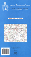
Topographic survey of Portugal at 1:25, 000 from the Instituto Geográfico do Exército, the country’s military survey organisation.Map legend and a glossary of terms used on the maps include English.To see all the titles in this series please click on the series link.

Product Description
Reviews/Comments
Add New
Vouchers
No voucher codes found.
Do you know a voucher code for this product or supplier? Add it to Insights for others to use.
Do you know a voucher code for this product or supplier? Add it to Insights for others to use.
 Denmark