
 United Kingdom
 France
 Germany
 Netherlands
 Sweden
 USA
USA
 Italy
Italy
 Spain
Spain
More From Contributor


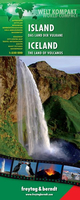
Iceland F&B World Compact Map
Iceland at 1:550, 000 on light, waterproof at tear-resistant map published by Freytag & Berndt in their “World Compact” series which combines a country map with street plans and extensive tourist information: descriptions of places of interest, a fact-box, etc.The map is double-sided, with a small overlap between the sides. Topography is very effectively shown by relief shading with contours and spot heights, plus colouring for glaciers and plenty of names of geographical features. National parks and other protected areas are highlighted. Road network indicates roads with hard, gravel and loose surface, includes selected mountain tracks, and gives distances on main routes. Locations of petrol stations and river fords are marked. Icons indicate numerous places of tourist
interest such as campsites, youth hostels, mountain cabins and shelters, geysers, UNESCO World Heritage sites, etc. The map is indexed and has latitude and longitude lines drawn at 30’ and 1° intervals respectively.A special feature of Freytag & Berndt’s World Compact series are additional street plans and information panels, illustrated with colour photos, with descriptions of main tourist destinations, important natural features, facts and figures about the country, a phrase book, tourist tips, etc. The map of Iceland includes a street plan of central Reykyavik.Map legend and all the text in the information panels is bilingual English – German.
interest such as campsites, youth hostels, mountain cabins and shelters, geysers, UNESCO World Heritage sites, etc. The map is indexed and has latitude and longitude lines drawn at 30’ and 1° intervals respectively.A special feature of Freytag & Berndt’s World Compact series are additional street plans and information panels, illustrated with colour photos, with descriptions of main tourist destinations, important natural features, facts and figures about the country, a phrase book, tourist tips, etc. The map of Iceland includes a street plan of central Reykyavik.Map legend and all the text in the information panels is bilingual English – German.

Product Description
Reviews/Comments
Add New
Vouchers
No voucher codes found.
Do you know a voucher code for this product or supplier? Add it to Insights for others to use.
Do you know a voucher code for this product or supplier? Add it to Insights for others to use.
 Denmark