
 United Kingdom
 France
 Germany
 Netherlands
 Sweden
 USA
USA
 Italy
Italy
 Spain
Spain
More From Contributor


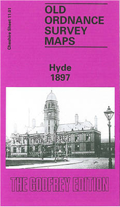
Hyde 1897
Hyde in 1897 in a fascinating series of reproductions of old Ordnance Survey plans in the Alan Godfrey Editions, ideal for anyone interested in the history of their neighbourhood or family. Selected towns in Great Britain and Ireland are covered by maps showing the extent of urban development in the last decades of the 19th and early 20th century.In this title: the map is double-sided and includes sheet Nos. 11.01 and 11.05. Please note that in this edition the Lancashire area west of the River Tame is left blank. Sheet 11.01 covers the town centre of Hyde, stretching from the Tame eastward to Cheapside and Lumn Street, and from St Stephen's church southward to Syddall Street. Features include Town Hall and Market, Peacock Coal Pit (disused), Millwood Mill, boiler works, Birch
House, Slack Mills, Hyde Hall, engineering works, Newtonbank Bleach Works, Hoviley Bridge (at east margin of map), Godley Brook, Carrfield Mill, Bayleyfield Mill, Hyde station, Floweryfield, Canal Iron Works, Kingston, Barnfield Mill, coal pit, Broomstair Bridge, Throstle Bank Mill, Floweyfield House etc. Sheet 11.05 on the reverse continues coverage southward towards Trianon Mill and Apethorn Junction. Features here include Apethorn Mill, Gibraltar Mill, Providence Mill, St George's church, Apethorn Lane, etc.About the Alan Godfrey Editions of the 25
House, Slack Mills, Hyde Hall, engineering works, Newtonbank Bleach Works, Hoviley Bridge (at east margin of map), Godley Brook, Carrfield Mill, Bayleyfield Mill, Hyde station, Floweryfield, Canal Iron Works, Kingston, Barnfield Mill, coal pit, Broomstair Bridge, Throstle Bank Mill, Floweyfield House etc. Sheet 11.05 on the reverse continues coverage southward towards Trianon Mill and Apethorn Junction. Features here include Apethorn Mill, Gibraltar Mill, Providence Mill, St George's church, Apethorn Lane, etc.About the Alan Godfrey Editions of the 25
Product Description
Reviews/Comments
Add New
Intelligent Comparison
Archived Product
Hyde 1897 Stanfords
£3.50
Archived Product
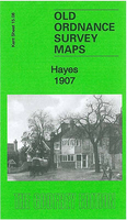
Hayes 1907 Stanfords
£3.50
Archived Product
Rye 1927 Stanfords
£3.50
Vouchers
No voucher codes found.
Do you know a voucher code for this product or supplier? Add it to Insights for others to use.
Do you know a voucher code for this product or supplier? Add it to Insights for others to use.
 Denmark