More From Contributor

£14.50
Detailed topographic map of the Hunza range north of the Karakoram Highway. The map was published in 1995 by the German Alpine Club, based on information provided by German-Austrian Himalayan Expedition in 1954 & German Karakoram Expedition of 1959. Margin ticks show latitude & longitude in steps of 10 ...
Archived Product
£14.50
Detailed topographic map of the Hunza range north of the Karakoram Highway. The map was published in 1995 by the German Alpine Club, based on information provided by German-Austrian Himalayan Expedition in 1954 & German Karakoram Expedition of 1959. Margin ticks show latitude & longitude in steps of 10Æ. Map legend is in German only. ...
Archived Product
£11.50
Topographic survey of France at 1:25, 000 in IGN`s excellent TOP25 / Série Bleue series. All the maps are GPS compatible, with a 1km UTM grid plus latitude & longitude lines at 5’ intervals. Contours are at 5m intervals except for mountainous areas where the maps have contours at 10m intervals, vividly enhanced by hill shading & graphics for rocky terrain. Colouring with graphics indicates different types of vegetation or land use (deciduous or coniferous forests, moors, orchards, vineyards, etc). PLEASE NOTE: coverage of France at this scale is currently being revised – the format & the presentation of each title are indicated by the letters at the end of its Sheet Reference number (e.g. 0416ET, 3531ETR, 1923SB, etc.)MAPS WITH FULL TOURIST OVERPRINT & AN ENGLISH MAP LEGEND: all TOP25 maps & the SB editions of Série Bleue have an overprint highlighting waymarked walking trails including long-distance GR routes &, where appropriate, ski routes. Symbols indicate campsites, gîtes d’etape, refuges, equestrian centres & other recreational facilities or sites, tourist information centres, cultural heritage, etc. Towns & locations of particular interest are highlighted.- ET or OT = single-sided TOP25 map covering approx. 29x 21 km / 18x 13 miles.- ETR or OTR = waterproof & tear resistant TOP25 map covering the same area as the corresponding ET or OT number, but double-sided, printed on a smaller size sheet with a good overlap between the sides.- SB = Série Bleue map with full tourist overprint; these maps, first introduced in summer 2014, each cover approx. 29x 24km / 18x 15 miles.SÉRIE BLEUE maps with numbers ending in E (Est) or O (Ouest): most editions now indicate the GR routes, but do not show any other tourist information. Map legend is in French only. Each map covers approx. 14x 20km / 9x 12 miles. ...
Archived Product
£9.99
Map No. 757, Huron National Forest, MI, in an extensive series of GPS compatible, contoured hiking maps of USA’s national & state parks or forests & other popular recreational areas. Cartography based on the national topographic survey, with additional tourist information. The maps, with most titles now printed on light, waterproof & tear-resistant plastic paper, highlight walking trails along with campsites & other accommodation, picnic sites, areas for various recreational pursuits such as horse riding or skiing, drinking water sources, & many other facilities of interest to the outdoor enthusiast. Cartography is based on information from the USGS (United States Geological Survey
- the country’s national survey organization), revised by the National Geographic Maps in cooperation with the National Park Service, USDA Forest Service, etc. Topography is excellently presented by contours (interval varies according to scale), enhanced by relief shading & colouring/graphics for wood cover, glaciers, etc. All heights are given in feet. The maps have a UTM grid plus latitude & longitude margin ticks & GPS waypoints for selected important locations. Each map is double-sided to give either maximum coverage of the chosen area or additional enlargements of its important sections. Accompanying notes provide useful information on relevant regulations, safety precautions, contact addresses, etc.* *IMPORTANT
- PLEASE NOTE: the series is very extensive, ranging in scale from 1:400, 000 for the vast national parks of Alaska to 1:25, 000 for local map in several states. We recommend, therefore, viewing the series by state rather than the whole list.*

...
Archived Product
£12.99
This book is not a how-to-guide. It won`t tell you how to get your baby to sleep, how to deal with toddler tantrums, how to be a good parent, a cool parent or even a renegade parent. It is a book about parenting that contains absolutely no useful advice whatsoever. Instead it shares beautifully honest anecdotes & illustrations from the parenting frontline that demonstrate it is perfectly possible to love your children with the whole of your heart whilst finding them incredibly irritating at the same time. From pregnancy to starting school, Hurrah For Gin takes you through the exciting, frustrating, infuriating & wonderful whirlwind of parenthood, offering solidarity & a friendly hug after a tough day. Best served with gin. ...
Archived Product
£23.99
Hurrungane area in Norway in a series of GPS compatible recreational maps at 1:25, 000 with cartography based on the country’s topographic survey & additional tourist information. The base map is an enlargement of the standard 1:50, 000 topographic survey series. Contours lines are drawn at 20m intervals. The overprint varies from title to title, but

Includes::
local footpaths, in some cases distinguishing between easy & more difficult trails, as well as mountain huts & campsites. Many titles also indicate cycle, ski or canoeing routes, other accommodation possibilities, sport & recreational facilities, including alpine skiing slopes, places of interest, etc. The maps have a UTM grid & margin ticks giving latitude & longitude. Map legend

Includes::
English. Several titles have on the reverse additional tourist information, although in most cases in Norwegian only. To see the list of Turkart maps at 1:25, 000 & links to Turkart series at 50K, 100K & Hiking Sets please click on the series link above.


...
Archived Product
£5.99
Hare is always raring to go. He races through the day while the ever-patient Tortoise does his best to keep up. Hare, it certainly seems to Tortoise, has boundless energy. So Tortoise has plans for when it is time for Hare to go to bed
- a well-deserved rest with a cup of chamomile tea! &, for the first time in the day, it is Tortoise who is in a hurry. He reads speedily, with one eye on his cuppa. But Hare has other ideas. As far as he is concerned, when it`s time for his bedtime story from Tortoise, he is no longer in a hurry. In fact he wants to take all the time in the world & linger over every picture. After all, some things just shouldn`t be rushed! Toddlers will love this simple story, with its cosy farmland setting & lovable characters. & while adults are reading a story that highlights the differences between the energetic & impetuous Hare & the rather more circumspect Tortoise, they will no doubt smile as they recognise the parallels with their own experiences of childcare!
...
Archived Product
£2.95
Hurst & North Ashton in 1906 in a fascinating series of reproductions of old Ordnance Survey plans in the Alan Godfrey Editions, ideal for anyone interested in the history of their neighbourhood or family. Selected towns in Great Britain & Ireland are covered by maps showing the extent of urban development in the last decades of the 19th & early 20th century. In this title: the map covers the northern part of Ashton-under-Lyne around Higher Hurst. Coverage stretches from Arlies Street at Ashton northward to the Knott Hill Reservoir, & from Ladbrooke Road eastward to the hamlet of Hazelhurst. Features include Whittakers Mills, Stamford Commercial Mill, Curzon Mill, Cedar Mill, Hurst Mills, Ashton Barracks, Hurst Hall, Hurst Nook, Hurst cemetery, tramways, St John's church, disused Broadbank Colliery, Holebottom, Timperley Fold, Greenhurst, Hazelhurst. Directories of Hurst in 1905 & 1918 are included on the reverse. About the Alan Godfrey Editions of the 25 ...
Archived Product
£3.50
Hurst & North Ashton in 1906 in a fascinating series of reproductions of old Ordnance Survey plans in the Alan Godfrey Editions, ideal for anyone interested in the history of their neighbourhood or family. The map covers the northern part of Ashton-under-Lyne around Higher Hurst. Coverage stretches from Arlies Street at Ashton northward to the Knott Hill Reservoir, & from Ladbrooke Road eastward to the hamlet of Hazelhurst. Features include Whittakers Mills, Stamford Commercial Mill, Curzon Mill, Cedar Mill, Hurst Mills, Ashton Barracks, Hurst Hall, Hurst Nook, Hurst cemetery, tramways, St John`s church, disused Broadbank Colliery, Holebottom, Timperley Fold, Greenhurst, Hazelhurst, etc. Directories of Hurst in 1905 & 1918 are on the reverse. About the Alan Godfrey Editions of the 25” OS Series: Selected towns in Great Britain & Ireland are covered by maps showing the extent of urban development in the last decades of the 19th & early 20th century. The plans have been taken from the Ordnance Survey mapping & reprinted at about 15 inches to one mile (1:4, 340). On the reverse most maps have historical notes & many also include extracts from contemporary directories. Most maps cover about one mile (1.6kms) north/south, one & a half miles (2.4kms) across; adjoining sheets can be combined to provide wider coverage.FOR MORE INFORMATION & A COMPLETE LIST OF ALL AVAILABLE TITLES PLEASE CLICK ON THE SERIES LINK. ...
Archived Product
£19.95
Topographic survey of Faroe Islands at 1:20, 000 prepared by the Danish national mapping agency Kort og Matrikelstyrelsen. The islands’ topography is vividly presented by contours at 5 metre intervals, enhanced by relief shading plus colouring and/or graphics for different types of terrain or vegetation (scree, boulders, etc). The maps show all the detail expected of the topographic mapping at this scale & have a 1-km UTM grid, plus margin ticks for latitude & longitude at 1’ & 2` respectively. Map legend is in Danish only. The maps are available either separately or as sets of five of more sheets, each covering the main island group: Vagar, Sandoy, Suduroy, Nordoyar, Streymoy & Eysturoy. To see the list of all the titles in this series please click on the series link. ...
Archived Product

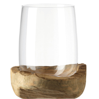
Hurricane Lamp With Teak Socket

LEONARDO is one of the most popular glassware brands in Europe and is active throughout the globe. An excellent quality at an affordable price. The designs consistently capture the spirit of the times. LEONARDO is a philosophy: the philosophy of inspiration.
RIP - This product is no longer available on our network. It was last seen on 25.09.2019

This page now acts as a permanent archive for this product. Add more information using the comments box below to ensure it can still be found by future generations.

Use our search facility to see if it is available from an alternative contributor.
  • External links may include paid for promotion
  • Availability: Out Of Stock
  • Supplier: Stanfords
  • SKU: 4002541844095
Availability: In Stock
£95.00

Product Description

LEONARDO is one of the most popular glassware brands in Europe & is active throughout the globe. An excellent quality at an affordable price. The designs consistently capture the spirit of the times. LEONARDO is a philosophy: the philosophy of inspiration.

Reviews/Comments

Add New

Intelligent Comparison

Oooops!
We couldn't find anything!
Perhaps this product's unique.... Or perhaps we are still looking for comparisons!
Click to bump this page and we'll hurry up.

Price History

Vouchers

No voucher codes found.
Do you know a voucher code for this product or supplier? Add it to Insights for others to use.

Facebook

Jargon Buster

Quality - An object that has quality is superior in function and finish than a less quality object.
Affordable - Something that is within a set price range that can be afforded due to its reasonable price.
Popular - Something that is admired and liked by many people.

Supplier Information

Stanfords
Stanfords was established in 1853 and opened their iconic Covent Garden flagship store in 1901. They have become the top retailer of maps, travel books and accessories in the UK and arguably offer the largest selection of maps and travel books worldwide. Famous names such as Captain Robert Falcon Scott, Ranulph Fiennes and Michael Palin have purchased from Stanfords. They now have a shop in Bristol and both stores together with other venues operate a calendar of events including talks, book signings and exhibitions. As a specialist map retailer, the map selection is comprehensive and includes road maps, street maps and walking maps from worldwide destinations, as well as a selection of world atlases and wall maps. Books include travel guides and travel literature. Stanfords also stock globes, from miniatures made of blue marble to magnificent floor-standing globes. The website features a selection of interesting articles on travel topics.
Page Updated: 2023-11-12 20:15:36

Community Generated Product Tags

Oh No! The productWIKI community hasn't generated any tags for this product yet!
Menu