More From Contributor

£13.95
Road atlas of Hungary at 1:250, 000 combined with a street atlas of Budapest at 1:20, 000 from Cartographia, presented in a handy glovebox size & spiral-bound format, each section with an extensive index, plus an enlargement of the Budapest region, etc. The road atlas section shows six different classes of roads, plus cart tracks & selected local footpaths. The maps indicate toll roads, scenic routes, sections closed to motorized traffic, gradients, locations of LPG fuel supplies, & driving distances on most local roads. Roads with a bicycle path & recommended cycle touring routes are also marked. Railway lines are shown with stations & stops. Narrow gauge lines, funiculars & ski lifts are included & on Lake Balaton ferry routes are marked. Picturesque towns or villages & other places of interest, including national parks & protected areas, are highlighted. Symbols mark locations of campsites & youth hostels, castles & churches, folk museums, spas, swimming pools, etc. The maps have no geographical coordinates. Extensive index lists all the localities with their postcodes & gives population details. The atlas

Includes::
an enlargement presenting the environs of Budapest (extending north to include Esztergom & Visegrad) in greater detail, plus a comprehensive distance table. The section with the street atlas of Budapest at 1: 20, 000 shows tram, bus & trolleybus routes with stops & line numbers; metro & suburban railway stations also have line numbers. For drivers, the atlas indicates main traffic arteries, one way streets, pedestrianized zones, & car parks. Streets are annotated with selected house numbers for easier identification of addresses. Important buildings are highlighted & named, & symbols indicate other places of interest and/or facilities. Extensive index

Includes::
lists with addresses of museums & other cultural or educational establishments, embassies, etc. Also provided is a diagram of the city’s nighttime public transport lines. Map legends for the two sections & other explanatory text include English.PLEASE NOTE: both the road atlas & the street atlas are also available separately.


...
Archived Product
£18.99
Hungary in Cambridge University Press’s Concise History series; exploring the history of a range of countries worldwide. Chronicling the country’s modern history since the Middle Ages, each title in the series has been comprehensively researched & written by an academic specialising in the field. Individual chapters chart the history of the nation, either by century or notable periods in its past, & are aimed both at those studying at undergraduate level or who may have a deeper interest in the country. ...
Archived Product
£6.95
Hungary in the Culture Smart range of pocket-sized guide books; providing detailed information on local customs, culture, etiquette & manners & ensuring that visitors are prepared for a diverse range of social environments. The series covers an extensive number of countries worldwide & are designed both for those working & living abroad, as well as for visitors who do not want to offend, either intentionally or inadvertently. Their aim is to prevent readers from making embarrassing mistakes & feel confident in unfamiliar situations, while preparing them before arrival on what to expect & how to behave. Each guide is arranged thematically, with dedicated individual chapters on land & people, values & attitudes, customs & traditions, making friends, people at home, ‘time-out’, travelling & communicating. There is also a separate chapter for business travelers, with important information on subjects such as business culture, meetings & making appointments. A Further Reading section also offers a list of recommended other history, travel literature & language titles available on the country. ...
Archived Product
£6.50
Clear, indexed, road map of Hungary, from Hungary`s leading cartographic publisher, Cartographia. Road details include six different kinds of roads plus tracks, with intermediate driving distances, petrol stations, & names & numbers on major roads. Railways, national & international boundaries with border crossings, ferry lines on rivers & airports are also marked, alongside national parks & population density.A series of details show campsites & hostels, caves, spot heights, World Heritage points, tourist & natural sights, spas, ruins & historical monuments. The legend is in English, German & Hungarian. Printed on paper with an index of place names on the reverse.N.B. This is exactly the same map as Hungary
- hard cover, but is presented without a plastified hard cover, which is more durable but more annoying to handle.
...
Archived Product
£120.00
Hungaria, an original antique map by Anonymous / P. Bertius, published in Amsterdam, 1598 -1609. A copperplate engraving, coloured. Map size 12 x 9 cm, with a mount size of 30 x 26.5 cm. At the end of the 16th Century pocket atlases began to appear in the marketplace, thus making geography available to a wider readership. Often using reduced versions of the work of the renowned cartographer Abraham Ortelius, they acquired great popularity on the continent of Europe. Charmingly engraved, this example from the Bertius series has Dutch text to the verso. Petrus Bertius went on to become Cosmographer to Louis XIII in 1618. Antique maps from various original publishers are presented on the Stanford ...
Archived Product
£15.99
Hungary in the Travel Guide series from Bradt; encompassing a comprehensive range of titles to destinations worldwide, with a particular focus on Africa, Central & South America. Bradt are one of the country’s leading independent publishers & have an ethos that focuses on responsible travel, in alliance with a philosophy of sustainability; both in the destinations the guides cover but also in encouraging tourists to limit the impact they have on the local environment. Bradt guides have a reputation for appealing to more independent travelers & often cover destinations that are not available from other publishers. Each guide opens with two comprehensive chapters on Background & Practical Information, covering details of the country’s geography, culture, natural history, government & politics, economy, people, language, religion, education & culture. Important practical advice

Includes::
when to visit, highlights, suggested itineraries, tour operators, red tape, embassies & consulates, getting there & away, health, safety, what to take, money, budgeting, getting around, accommodation, eating & drinking, public holidays, shopping, arts & entertainment, media & communications, business, travel culture & cultural etiquette. Individual sections are organized geographically by region & typically open with information on practicalities & orientation, before focusing on what to see & where to go. Information on what to see, where to stay, where to eat & how to find your way around is provided, with a range of budgets catered for. Simple black & white maps locate key visitor sites & places of accommodation. Bradt Travel Guides include appendices that provide an in-depth introduction to the language of each country, a glossary of terms & a listing of books & internet resources providing further information on the destination.

...
Archived Product
£11.99
Hungary in Marshall Cavendish's Culture Shock! Series; comprising a range of guides that inform visitors of the finer points & details relating to social etiquette, traditions & customs; bringing visitors to a sensitive yet substantial understanding of the country or city in question. The series targets those who are planning long stays in the destination or extended periods of residence. The guides are written by authors who have experienced the joys & pitfalls of cultural adaptation, & so are ideally placed to provide informative & relevant advice. Each title contains insights into local culture & traditions, guidance on adapting to the local environment, linguistic help & lots of general advice about local culture & idiosyncrasies to help prepare readers for their visit. Each title is structured similarly, beginning with the first impressions a visitor might expect to have. The guides aim to help readers understand the local culture through first appreciating the motivations, beliefs & attitudes of the local people. Practical advice on settling in is provided, with focused sections on accommodation, utilities, health, education & telecommunications. There is also extensive information on the destination ...
Archived Product
£18.95
Hungary Cycling Atlas at 1: 250, 000 from Frigoria in a spiral-bound format with 100 selected routes & a 111-page guide section with English language lists and/or descriptions of main sights in numerous towns & villages. The atlas covers the whole country at 1:250, 000 on very clear detailed road maps overprinted with the 100 selected routes & their variants, including two Euro Velo routes: No. 6 along the Danube & No. 11 along the Bodrog & the Tisza. The overprint indicates sections along paved bicycle paths or cycle lanes, ...
Archived Product
£24.95
Hungary Cycling Atlas at 1: 250, 000 from Frigoria in a spiral-bound format with 100 selected routes & an extensive guide section with English language lists and/or descriptions of main sights in numerous towns & villages. The atlas covers the whole country at 1:250, 000 on very clear detailed road maps overprinted with the 100 selected routes & their variants, including two Euro Velo routes: No. 6 along the Danube & No. 11 along the Bodrog & the Tisza. An enlargement shows the Budapest area in greater detail. The overprint indicates sections along paved bicycle paths or cycle lanes, ...
Archived Product
£24.99
Hungary Cycling Atlas at 1: 250, 000 from Frigoria in a spiral-bound format with 100 selected routes & an extensive guide section with English language lists and/or descriptions of main sights in numerous towns & villages. The atlas covers the whole country at 1:250, 000 on very clear detailed road maps overprinted with the 100 selected routes & their variants, including two Euro Velo routes: No. 6 along the Danube & No. 11 along the Bodrog & the Tisza. An enlargement shows the Budapest area in greater detail. The overprint indicates sections along paved bicycle paths or cycle lanes, “cycle-friendly” stretches, routes on dirt tracks, intermediate cycling distances, & locations of hire/maintenance bike shops. Other information on the maps

Includes::
detailed grading of the road network, with motorway facilities, routes closed to traffic, distances on small local roads, etc; railway lines with stations; accommodation including selected hotels & motels, campsites, youth hostels, tourist hostels; extensive overprint for various places of interest or sport & recreational facilities, etc. There is no specific topographic information (contours or shading) beyond some spot heights, colouring for wooded areas & graphics for marshes. National parks & protected areas as clearly marked. The atlas is indexed & for GPS users has latitude & longitude grid at 10’ intervals. Each route is listed separately in the introductory part of the atlas with a list of towns & villages, total length & a brief description of landscape, road conditions & general ambiance. The atlas also has an extensive guide section of nearly 100 pages, listing all towns & villages of interest with their main sights, museums, examples of local architecture, etc. Map legend, route descriptions & the guide section all include English.

...
Archived Product

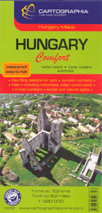
Hungary ”Comfort” Map

Clear, indexed, road map of Hungary at a scale of 1:520, 000, from Hungary`s leading cartographic publisher, Cartographia.Road details include six different kinds of roads plus tracks, with intermediate driving distances, petrol stations, and names and numbers on major roads. Railways, national and international boundaries with border crossings, ferry lines on rivers and airports are also marked, alongside national parks and population density.A series of details shows campsites and hostels, caves, spot heights, World Heritage points, tourist and natural sights, spas, ruins and historical monuments.The legend is in English, German and Hungarian.An index of place names features on the reverse.N.B. This is exactly the same cartography as `Hungary - soft cover` by
Cartagraphia, but is presented with a plasticized, water-proof and easy-to-fold hard cover.
RIP - This product is no longer available on our network. It was last seen on 25.09.2019

This page now acts as a permanent archive for this product. Add more information using the comments box below to ensure it can still be found by future generations.

Use our search facility to see if it is available from an alternative contributor.
  • External links may include paid for promotion
  • Availability: Out Of Stock
  • Supplier: Stanfords
  • SKU: 9789633526323
Availability: In Stock
£9.50

Product Description

Clear, indexed, road map of Hungary at a scale of 1:520, 000, from Hungary`s leading cartographic publisher, Cartographia. Road details include six different kinds of roads plus tracks, with intermediate driving distances, petrol stations, & names & numbers on major roads. Railways, national & international boundaries with border crossings, ferry lines on rivers & airports are also marked, alongside national parks & population density.A series of details shows campsites & hostels, caves, spot heights, World Heritage points, tourist & natural sights, spas, ruins & historical monuments. The legend is in English, German & Hungarian. An index of place names features on the reverse.N.B. This is exactly the same cartography as ` Hungary
- soft cover` by Cartagraphia, but is presented with a plasticized, water-proof & easy-to-fold hard cover.

Reviews/Comments

Add New

Intelligent Comparison

Oooops!
We couldn't find anything!
Perhaps this product's unique.... Or perhaps we are still looking for comparisons!
Click to bump this page and we'll hurry up.

Price History

Vouchers

No voucher codes found.
Do you know a voucher code for this product or supplier? Add it to Insights for others to use.

Facebook

Jargon Buster

water - A chemical substance. Chemical formula H2O.
soft - A descriptive word for an item/sound which is gentle to the touch or ears
Railways - A set of tracks that have been laid for the purpose of trains to travel up and down them
World - A physical grouping, commonly used to describe earth and everything associated with ti
Natural - not manmade
Comfort - something that feels nice to the user. Often relaxing.
Road - a manmade lane or a path that is used to speed up travel.

Supplier Information

Stanfords
Stanfords was established in 1853 and opened their iconic Covent Garden flagship store in 1901. They have become the top retailer of maps, travel books and accessories in the UK and arguably offer the largest selection of maps and travel books worldwide. Famous names such as Captain Robert Falcon Scott, Ranulph Fiennes and Michael Palin have purchased from Stanfords. They now have a shop in Bristol and both stores together with other venues operate a calendar of events including talks, book signings and exhibitions. As a specialist map retailer, the map selection is comprehensive and includes road maps, street maps and walking maps from worldwide destinations, as well as a selection of world atlases and wall maps. Books include travel guides and travel literature. Stanfords also stock globes, from miniatures made of blue marble to magnificent floor-standing globes. The website features a selection of interesting articles on travel topics.
Page Updated: 2023-11-12 20:15:36

Community Generated Product Tags

Oh No! The productWIKI community hasn't generated any tags for this product yet!
Menu