More From Contributor
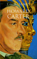
£12.99
This lavish cloth-bound gift edition faithfully recreates in beautiful detail the Sherlock Holmes story Arthur Conan Doyle wrote especially for the Library of Queen Mary`s Dolls` House in 1922. In this classic story, Watson tries to mimic Holmes`s mastery of the art of deduction with very funny results, making this a book for both adults & children to delight in. Alongside the miniature book, which measures just 38.5 x 30 mm, the edition also contains an informative booklet with a transcript of the story & information about the Dolls` House. Queen Mary`s Dolls` House is the largest & most famous of its kind in the world, & has a library containing miniature works by all the major writers & artists of the day. ...
Archived Product
£20.00
This is the story of Britain told through its buildings & the people who built them. Join David Dimbleby on his colourful chronological journey through the nation's architectural landscape: to towering fortresses, timber-framed barns, magnificent palaces, railway viaducts, music halls, suburban homes & tower blocks. He climbs to the top of the light-flooded Ely Cathedral, a looming vision of Norman conquest & domination; he explores Harvington Hall in Worcestershire, riddled with hidden passages to conceal Catholic priests; he delves into Manchester's network of sewers, constructed to flush away the polluted waters of disease; & he takes a quizzical look at the Scottish Parliament in Edinburgh, the symbol of devolution. Tying in with the hit BBC1 series & generously illustrated with specially commissioned colour photography & over 100 historic images, this book reveals how these structures originated in the experiences & beliefs of the British people, & how they hold the key to who we are. ...
Archived Product
£20.00
Although nearly 90% of the population of Great Britain remained civilians throughout the war, or for a large part of it, their story has so far largely gone untold. In contrast with the thousands of books on military operations, barely any have concerned themselves with the individual`s experience. The problems of the ordinary family are barely ever mentioned
- food rationing, clothes rationing, the black-out & air raids get little space, & everyday shortages almost none at all. This book is an attempt to redress the balance; to tell the civilian`s story largely through their own recollections & in their own words.
...
Archived Product
£14.99
Where do our clothes come from? What`s the link between gorillas & mobile phones? Does chocolate grow on trees? Answering these questions & many more, How We Make Stuff is an engaging exploration of the way we use Earth`s natural resources. Featuring pop-ups, pull-tabs & booklets, it is an interactive extravaganza! The first title in the series, How The World Works, won the prestigious Royal Society Young People`s Book Prize. ...
Archived Product
£7.99
Part of the TED series: How We`ll Live on Mars It sounds like science fiction, but award-winning journalist Stephen Petranek considers it fact: within 20 years, humans will live on Mars. We`ll need to. In this sweeping, provocative book that mixes business, science & human reporting, Petranek makes the case that living on Mars is an essential back-up plan for humanity, & explains in fascinating detail just how it will happen. It`s clear that the race is on. Private companies (driven by iconoclastic entrepreneurs like Elon Musk & Sir Richard Branson); Dutch reality show/space mission Mars One; NASA & the Chinese government are among the many groups competing to plant the first stake on Mars & open the door for human habitation. For Elon Musk, it`s the ”ultimate awesome thing.” For other entrepreneurs, it`s about competition & opportunity. For NASA, the Chinese government & the leagues of other private companies & foreign nationals racing to get to Mars, there are more urgent reasons as well: life on Mars has potential life-saving possibilities for us on earth. Depleting water supplies, overwhelming climate change & a host of other disasters
- from terrorist attacks to meteor strikes
- all loom large. We must become a space-faring species to survive. In this close-up narrative chronicle, Petranek introduces the circus of lively characters all engaged in a big-money, big-drama effort to expand the limits of human knowledge
- & life
- by being the first to settle on the Red Planet. How We`ll Live on Mars brings first-hand reporting, interviews with key players & extensive research to bear on the question of how we can best, & most plausibly, expect to see life on Mars
- within the next 20 years. Petranek can also be seen discussing his fascinating ideas in his TEDTalk 10 Ways The World Could End.


...
Archived Product
£6.39
A detailed topographic map of Howardian Hills & Malton from the Ordnance Survey Explorer series, covering Yorkshire Wolds North. Edition A2; Publication date January 2006 About this series: These highly detailed maps show all the administrative boundaries, settlements as small as isolated farms, the road network down to unfenced roads & country tracks, & field boundaries (hedges & drystone walls) which make navigation across the countryside much easier. Steep gradients on roads are indicated. Various landmarks, e.g. powerlines, archaeological sites, windmills, churches & lighthouses are shown & additional graphics indicate natural terrain features such as cliffs, scree, mud & vegetation variations. The contour interval is 5 metres in the lower parts of the country & 10 metres in the uplands, & spot heights are marked. Each map covers an area of 30 x 20km (i.e. approx. 19 x 12 miles), with some double-sided maps covering more, as indicated in the individual descriptions. The maps are fully GPS compatible, with the National Grid shown at 1km intervals & latitude & longitude indicated by margin ticks at 1'. The Explorer series has replaced the earlier, green-cover Pathfinder maps. The Explorer series is now complete & covers all of Engl&, Wales & Scotl&. Some sheets for popular areas like the National Parks are still branded as Outdoor Leisure (OL) maps, but are now included in this series as the cartography is the same as that in the Explorer Maps. The Explorer maps offer a substantial improvement on the Pathfinder series, with greater use of colour, larger area per map, & stronger emphasis on information for ramblers & tourists. This series is ideal for walking & other outdoor pursuits & each map shows a large amount of information for ramblers & tourists. Public rights of way are shown (except in Scotland), together with other routes with public access: National Trails & Recreational Paths, permitted paths & bridleways, & selected cycle routes. Open access land created under the Countryside & Rights of Way Act 2000 is marked. Tourist information

Includes::
caravan & camp sites, Park & Ride locations, recreation/leisure/sport centres, museums, historic buildings, English Heritage & National Trust sites, rural pubs, etc. The map legend is in English only, except for the tourist information content which is also in French & German.

...
Archived Product
£14.99
Howardian Hills, Malton & Yorkshire Wolds North area on a detailed topographic & GPS compatible map No. 300, waterproof version, from the Ordnance Survey’s 1:25, 000 Explorer series. MOBILE DOWNLOADS: this title & all the other OS Explorer maps include a code for downloading after purchase the digital version onto your smartphone or tablet for viewing on the OS smartphone app.OS EXPLORER SERIES: to see the list of all the titles in the OS Explorer series, both paper & waterproof versions, please click on the series link. The Explorer series, Ordnance Survey’s most detailed maps recommended for anyone enjoying outdoor activities, provides topographic coverage of Great Britain at 1:25, 000 on GPS compatible maps with hiking trails, cycling routes & extensive tourist information. Each printed map is available either on paper or as a waterproof & tear-resistant OS Active Map, as indicated in its title. Britain’s National Parks & other areas of particular tourist interest are presented on often double-sided OL (Outdoor Leisure) maps, whilst most standard format Explorers cover an area of 30 x 20km (approx. 19 x 12 miles). All three versions (paper, waterproof & digital) are the same & provide plenty of recreational & tourist information, indicating the traditional public right of way paths (except in Scotland where different laws apply), including bridleways & byways. National Trails & other long-distance paths are marked, as well as permissive footpaths or bridleways & on-road or traffic-free cycle routes with, where appropriate, their National/ Regional Cycle Network numbers. Boundaries of access land are clearly marked. A wide range of symbols provides additional tourist information, highlighting camping & caravanning sites, information offices & visitors’ centres, parking & picnicking places, country pubs, sport & recreational facilities including cycle hire locations & mountain biking trails, historic buildings & museums, etc. Exceptionally clear presentation of the landscape is provided by contours at 5m or in the uplands at 10m intervals, with additional spot heights plus colouring and/or graphics for different types of woodlands, orchards, heath, marshl&, scree or boulders, & other topographic features. For GPS users the maps have British National Grid lines at 1km intervals, with latitude & longitude given by margin ticks at 1`. Clearly laid out map legend

Includes::
French & German translations for the tourist information symbols.

...
Archived Product
£8.99
Howardian Hills, Malton & Yorkshire Wolds North area on a detailed topographic & GPS compatible map No. 300, paper version, from the Ordnance Survey’s 1:25, 000 Explorer series.MOBILE DOWNLOADS: this title & all the other OS Explorer maps include a code for downloading after purchase the digital version onto your smartphone or tablet for viewing on the OS smartphone app.OS EXPLORER SERIES: to see the list of all the titles in the OS Explorer series, both paper & waterproof versions, please click on the series link. The Explorer series, Ordnance Survey’s most detailed maps recommended for anyone enjoying outdoor activities, provides topographic coverage of Great Britain at 1:25, 000 on GPS compatible maps with hiking trails, cycling routes & extensive tourist information. Each printed map is available either on paper or as a waterproof & tear-resistant OS Active Map, as indicated in its title. Britain’s National Parks & other areas of particular tourist interest are presented on often double-sided OL (Outdoor Leisure) maps, whilst most standard format Explorers cover an area of 30 x 20km (approx. 19 x 12 miles). All three versions (paper, waterproof & digital) are the same & provide plenty of recreational & tourist information, indicating the traditional public right of way paths (except in Scotland where different laws apply), including bridleways & byways. National Trails & other long-distance paths are marked, as well as permissive footpaths or bridleways & on-road or traffic-free cycle routes with, where appropriate, their National/ Regional Cycle Network numbers. Boundaries of access land are clearly marked. A wide range of symbols provides additional tourist information, highlighting camping & caravanning sites, information offices & visitors’ centres, parking & picnicking places, country pubs, sport & recreational facilities including cycle hire locations & mountain biking trails, historic buildings & museums, etc. Exceptionally clear presentation of the landscape is provided by contours at 5m or in the uplands at 10m intervals, with additional spot heights plus colouring and/or graphics for different types of woodlands, orchards, heath, marshl&, scree or boulders, & other topographic features. For GPS users the maps have British National Grid lines at 1km intervals, with latitude & longitude given by margin ticks at 1`. Clearly laid out map legend

Includes::
French & German translations for the tourist information symbols.

...
Archived Product
£11.19
Laminated waterproof edition of a detailed topographic map of Howardian Hills & Malton from the Ordnance Survey Explorer series, covering the North Yorkshire Wolds. Edition A2; Publication date March 2006 About this series: These highly detailed maps show all the administrative boundaries, settlements as small as isolated farms, the road network down to unfenced roads & country tracks, & field boundaries (hedges & drystone walls) which make navigation across the countryside much easier. Steep gradients on roads are indicated. Various landmarks, e.g. powerlines, archaeological sites, windmills, churches & lighthouses are shown & additional graphics indicate natural terrain features such as cliffs, scree, mud & vegetation variations. The contour interval is 5 metres in the lower parts of the country & 10 metres in the uplands, & spot heights are marked. Each map covers an area of 30 x 20km (i.e. approx. 19 x 12 miles), with some double-sided maps covering more, as indicated in the individual descriptions. The maps are fully GPS compatible, with the National Grid shown at 1km intervals & latitude & longitude indicated by margin ticks at 1'. The Explorer series has replaced the earlier, green-cover Pathfinder maps. The Explorer series is now complete & covers all of Engl&, Wales & Scotl&. Some sheets for popular areas like the National Parks are still branded as Outdoor Leisure (OL) maps, but are now included in this series as the cartography is the same as that in the Explorer Maps. The Explorer maps offer a substantial improvement on the Pathfinder series, with greater use of colour, larger area per map, & stronger emphasis on information for ramblers & tourists. This series is ideal for walking & other outdoor pursuits & each map shows a large amount of information for ramblers & tourists. Public rights of way are shown (except in Scotland), together with other routes with public access: National Trails & Recreational Paths, permitted paths & bridleways, & selected cycle routes. Open access land created under the Countryside & Rights of Way Act 2000 is marked. Tourist information

Includes::
caravan & camp sites, Park & Ride locations, recreation/leisure/sport centres, museums, historic buildings, English Heritage & National Trust sites, rural pubs, etc. The map legend is in English only, except for the tourist information content which is also in French & German.

...
Archived Product
£6.99
The Penguin English Library Edition of Howards End by E. M. Forster` The poor cannot always reach those whom they want to love, & they can hardly ever escape from those whom they love no longer. We rich can` Only connect.` is the idea at the heart of this book, a heartbreaking & provocative tale of three families at the beginning of the twentieth century: the rich Wilcoxes, the gentle, idealistic Schlegels & the lower-middle class Basts. As the Schlegel sisters try desperately to help the Basts & educate the close-minded Wilcoxes, the families are drawn together in love, lies & death. Frequently cited as E. M. Forster`s finest work, Howards End brilliantly explores class warfare, conflict & the English character. The Penguin English Library
- 100 editions of the best fiction in English, from the eighteenth century & the very first novels to the beginning of the First World War.
...
Archived Product

Howard Carter

In November 1922, a momentous discovery - unlike any other before or since - was to change our understanding of the ancient world. Until now however, the marvellous story of Carter`s quest for Tutankhamun and its culmination in his unearthing of the intact, treasure-filled tomb has been told without a reliable account of the man behind the discovery and the myths that have surrounded it. Howard Carter`s career was a remarkable one: he had arrived in Egypt 30 years earlier as a 17-year old `tracer` with rudimentary education, and progressed to become the first Chief Inspector of Antiquities in Upper Egypt. An improbable but auspicious partnership with the 5th Earl of Carnarvon developed in which the young Carter acted as assistant and `learned man` to the aristocrat`s excavations in the
Theban necropolis. But, it was the legendary discovery in the Valley of the Kings and Carter`s painstaking clearance of the intact royal burial that was to secure his place in history. He became an international celebrity, simultaneously honoured and vilified wherever he went, but he was also a sad, disillusioned man whose success never brought any reward of happiness.TGH James` definitive biography is both the story of perhaps the most renowned archaeologist of all time and of an essentially tragic human being.
RIP - This product is no longer available on our network. It was last seen on 25.09.2019

This page now acts as a permanent archive for this product. Add more information using the comments box below to ensure it can still be found by future generations.

Use our search facility to see if it is available from an alternative contributor.
  • Availability: Out Of Stock
  • Supplier: Stanfords
  • SKU: 9781845112585
Availability: In Stock
£12.99

Product Description

In November 1922, a momentous discovery
- unlike any other before or since
- was to change our understanding of the ancient world. Until now however, the marvellous story of Carter`s quest for Tutankhamun & its culmination in his unearthing of the intact, treasure-filled tomb has been told without a reliable account of the man behind the discovery & the myths that have surrounded it. Howard Carter`s career was a remarkable one: he had arrived in Egypt 30 years earlier as a 17-year old `tracer` with rudimentary education, & progressed to become the first Chief Inspector of Antiquities in Upper Egypt. An improbable but auspicious partnership with the 5th Earl of Carnarvon developed in which the young Carter acted as assistant & `learned man` to the aristocrat`s excavations in the Theban necropolis. But, it was the legendary discovery in the Valley of the Kings & Carter`s painstaking clearance of the intact royal burial that was to secure his place in history. He became an international celebrity, simultaneously honoured & vilified wherever he went, but he was also a sad, disillusioned man whose success never brought any reward of happiness.TGH James` definitive biography is both the story of perhaps the most renowned archaeologist of all time & of an essentially tragic human being.

Reviews/Comments

Add New

Intelligent Comparison

Oooops!
We couldn't find anything!
Perhaps this product's unique.... Or perhaps we are still looking for comparisons!
Click to bump this page and we'll hurry up.

Price History

Vouchers

No voucher codes found.
Do you know a voucher code for this product or supplier? Add it to Insights for others to use.

Facebook

Jargon Buster

Education - A term used to describe the act of learning a new skill or information
Human - A highly developed and adapted mamal and deminant species on earth
History - Anything that happens in the past. An acedemic subject.
World - A physical grouping, commonly used to describe earth and everything associated with ti
Year - The time it takes the planet earth to orbit the sun. This takes around 365.25 days.
Reliable - Something that is consistently good and can be trusted.
Year - 365 days (366 days in a leap year), the time taken for planet earth to make one full revolution around the sun.

Supplier Information

Stanfords
Stanfords was established in 1853 and opened their iconic Covent Garden flagship store in 1901. They have become the top retailer of maps, travel books and accessories in the UK and arguably offer the largest selection of maps and travel books worldwide. Famous names such as Captain Robert Falcon Scott, Ranulph Fiennes and Michael Palin have purchased from Stanfords. They now have a shop in Bristol and both stores together with other venues operate a calendar of events including talks, book signings and exhibitions. As a specialist map retailer, the map selection is comprehensive and includes road maps, street maps and walking maps from worldwide destinations, as well as a selection of world atlases and wall maps. Books include travel guides and travel literature. Stanfords also stock globes, from miniatures made of blue marble to magnificent floor-standing globes. The website features a selection of interesting articles on travel topics.
Page Updated: 2023-11-12 20:15:36

Community Generated Product Tags

Oh No! The productWIKI community hasn't generated any tags for this product yet!
Menu