
 United Kingdom
 France
 Germany
 Netherlands
 Sweden
 USA
USA
 Italy
Italy
 Spain
Spain
More From Contributor


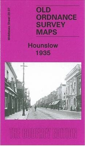
Hounslow 1935
Hounslow in 1935 in a fascinating series of reproductions of old Ordnance Survey plans in the Alan Godfrey Editions, ideal for anyone interested in the history of their neighbourhood or family. Two versions of the map have been published, showing how the area changed across the years. The south-western quarter of the 1894 map covers the centre of Hounslow, including High Street, Hanworth Road and Inwood Road; features include Holy Trinity church, Heston Hounslow station and Hounslow Town station (already shown here as disused). To the north Lampton Road leads up past Lampton House to Lampton. The London Road leads north-east to Spring Grove, an estate laid out in the 1850s by H.D.Davies; at the centre of this is Spring Grove Road, once home to the naturalist and traveller Sir Jospeh
Banks, but by the 1890s remodelled for Andrew Pears, of the soap family. Nearby is Woodlands, including St John`s church, part of Isleworth; Spring Grove and Isleworth station is near the east end of the map. At the foot of the map are Worton Hall and Worton Farm. On the 1935 map include the tramway and the Worton or Interworld Film Studios, famous first for many silent films and later for films produced by Alexander Korda and others. On the reverse of this map is a list of private residents from a 1933 directory. About the Alan Godfrey Editions of the 25” OS Series:Selected towns in Great Britain and Ireland are covered by maps showing the extent of urban development in the last decades of the 19th and early 20th century. The plans have been taken from the Ordnance Survey mapping
and reprinted at about 15 inches to one mile (1:4, 340). On the reverse most maps have historical notes and many also include extracts from contemporary directories. Most maps cover about one mile (1.6kms) north/south, one and a half miles (2.4kms) across; adjoining sheets can be combined to provide wider coverage.FOR MORE INFORMATION AND A COMPLETE LIST OF ALL AVAILABLE TITLES PLEASE CLICK ON THE SERIES LINK.

Product Description
Reviews/Comments
Add New
Intelligent Comparison
Archived Product
Hounslow Heath 1934 Stanfords
£3.50
Archived Product
Hunslet 1905 Stanfords
£3.50
Archived Product
Hounslow West 1894 Stanfords
£3.50
Vouchers
No voucher codes found.
Do you know a voucher code for this product or supplier? Add it to Insights for others to use.
Do you know a voucher code for this product or supplier? Add it to Insights for others to use.
 Denmark