
 United Kingdom
 France
 Germany
 Netherlands
 Sweden
 USA
USA
 Italy
Italy
 Spain
Spain
More From Contributor

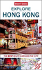
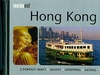
Hong Kong Flexi Map
Hong Kong on an Insight Flexi Map in their new format introduced to provide more convenient access to the special features of this series: various additional maps and/or street plans plus tourist information including a list of must-see sights. The map is tear-resistant, waterproof, and can be written on with non-permanent marker pens.On one side is a street plan at 1:10, 500 covering central Hong Kong and Kowloon on both sides of the Victoria Harbour. The index, placed on the reverse side, lists streets, country parks, parks and gardens, points of interest, hotels and shopping centres/markets.On the reverse are the title’s additional features:- A diagram of Hong Kong’s MTR transport system.- An indexed road map at 1:215, 000 covering the whole of the Hong Kong Special
Administrative Region, showing road access to Shenzhen. - Brief descriptions of 36 main sights, grouped for Hong Kong into sections covering Major Attractions, Notable Buildings, Museum and Galleries, and Shopping/Markets/Nightlife, plus New Territories and the Outlying Islands. All are prominently highlighted on the street plan and the road map.- Information about Getting Around and Facts for Visitors, including tourist offices, public holidays, opening times, money, tipping, telecommunications and monthly climate charts.To see the list of other Insight Flexi titles in this series please click on the series link.
Administrative Region, showing road access to Shenzhen. - Brief descriptions of 36 main sights, grouped for Hong Kong into sections covering Major Attractions, Notable Buildings, Museum and Galleries, and Shopping/Markets/Nightlife, plus New Territories and the Outlying Islands. All are prominently highlighted on the street plan and the road map.- Information about Getting Around and Facts for Visitors, including tourist offices, public holidays, opening times, money, tipping, telecommunications and monthly climate charts.To see the list of other Insight Flexi titles in this series please click on the series link.
Product Description
Reviews/Comments
Add New
Vouchers
No voucher codes found.
Do you know a voucher code for this product or supplier? Add it to Insights for others to use.
Do you know a voucher code for this product or supplier? Add it to Insights for others to use.
 Denmark