More From Contributor

£16.99
Topographic survey of Sweden at 1:50, 000, the Terrängkartan, from the Lantmäteriet, covering most of the country in 244 double-sided maps. Please note: the mountainous regions of central & northern Sweden are not covered by this series but presented in a separate “ Fjällkartan
- Mountain Map” series also listed on our website. Each 1:50, 000 topographic survey map covers an area of 37.5 x 40km. The maps have contours at 5 metre intervals, plus relief shading & graphics for rocky outcrops & boulders. Further graphics and/or colouring show different types of land use or vegetation (forests, arable l&, orchards, marshes, peat bogs, etc). An unusual feature of this survey is the colouring indicating buildings below or above two storeys high & “leisure/holiday homes”. The maps indicate privately maintained roads & include all other information expected of topographic survey at this scale. The maps have a 1-km UTM grid, plus latitude & longitude lines 5’ intervals. Map legend

Includes::
English. For coverage of the country’s most visited hiking areas in central & northern Sweden please see Lantmäteriet’s Mountain Map series, listed separately on our website.


...
Archived Product
£14.99
Hofsjökull, map no. 16, in the topographic survey of Iceland at 1:100, 000 published by Mál og menning, with excellent, vivid presentation of the terrain, footpaths & bridleways, campsites, etc. The maps have contours at 20m intervals, enhanced by bold relief shading plus colouring and/or graphics to show glaciers, lava fields, sands & mudflats, as well as to distinguish land with vegetation cover from the more sparsely covered terrain. The series provides a splendid presentation of the country’s topography, with large amount of detail & over 43, 000 place names. Road network indicates gravel roads &

Includes::
country tracks. Also marked are local footpaths, clear to see with their distinctive colouring, & bridleways. Symbols shows campsites, tourist huts or shelters, emergency shelters, summer houses, river fords, golf courses & swimming pools, hydro-electric or thermal power stations, local airports, etc, & detail such as individual farms, abandoned farms or ruins, sheepfolds, etc. Each map covers an area of 84 x 67km (53 x 42 miles approx.) & has latitude & longitude lines drawn at intervals of 2’ & 5’ respectively. Map legend

Includes::
English, German & French. To see the other titles in this series please click on the series link.


...
Archived Product
£9.99
William Hogarth (1697-1764) is an artist whose popularity has never waned since his own day. He has been characterized variously as a witty satirist, stern moralist, aggressive self-promoter, detached observer, & man of the people. His celebrated patriotism & Britishness were shaped, paradoxically, by the remarkably cosmopolitan character of the artistic environment in which he lived. His distinctive urban & political themes reflect the concerns of an increasingly metropolitan society. Hogarth's contribution to the development of modern British art was unique & his influence has been enormous, his multi-faceted output ranging from elegant conversation pieces to salacious brothel scenes. His reputation has been based almost entirely on his numerous prints & engraved works, including famous series such as A Rake's Progress, A Harlot's Progress, Marriage A-la-Mode, Industry & Idleness, Gin Lane, Beer Street & The Four Stages of Cruelty. This attractive book reproduces a selection from these & other representative prints, introduced by a brief overview of the artist & his times. ...
Archived Product
£29.99
Follow in the footsteps of your favourite wizards & head off to school with your very own Hogwarts Backpack. Fill it with books of spells & potions & take a little bit of magic with you everywhere you go. This wonderful nylon backpack is in the Hogwarts colours & features an embroidered Hogwarts Crest. An amazing gift for Harry Potter fans, this bag has PVC backing, metal zip pulls & is Approx. 42cm tall. ...
Archived Product
£24.99
This magical Harry Potter umbrella is the perfect Autumn/ Winter accessory. When dry, the design features a white Hogwarts crest on each panel. In the rain, the umbrella magically transforms to show the crests in full colour. This three fold umbrella features an extendable shaft, rubber handle with string hook & matching sleeve with ` Hogwarts` wording on it for easy storage. A great addition to any Harry Potter display & a must have for fans. ...
Archived Product
£12.99
Take the magic of Harry Potter with you on the go with this Harry Potter inspired Hogwarts Travel Mug. A stainless steel travel mug featuring the iconic crest of Hogwarts School of Witchcraft & Wizardry, this is the perfect gift for Harry Potter fans, as well as the best way of keeping your potion at just the right temperature! Double walled for extra insulation, the Hogwarts Travel Mug is ideal for journeys & commutes, or just for a warm drink on your lunch break. First published in 1997, J.K. Rowling`s bestselling series of novels following the magical adventures of Harry Potter, Ron Weasley & Hermione Granger has since become a cultural phenomenon. A huge success in novel form, the world of witchcraft & wizardry was then given big screen treatment in 2001, launching one of the most successful blockbuster film franchises in cinema history. Harry Potter is instantly recognisable to millions of people across the world, & is hugely popular among fans of all ages. The Hogwarts Travel Mug is an officially licensed product.
- Take the magic of Harry Potter with you on the go!
- Perfect for keeping your potion at the right temperature
- Features the iconic Hogwarts Crest- Double walled for extra insulation
- Officially licensed Harry Potter product


...
Archived Product
£12.99
Hohe Mark / Münsterland West area in Germany at 1:50, 000 from Kümmerly+ Frey in a series GPS compatible, double-sided maps printed on durable, waterproof & tear-resistant plastic paper; contoured, with hiking & cycle routes, other recreational activities, etc. Maps in this series are at a scale of either 1:50, 000 or 1:35, 000. Contour interval varies from 10m to 40m according to the area &, where appropriate, the maps have finely drawn additional graphic relief to provide an excellent representation of the terrain, with plenty of names of peaks, valleys, etc, national parks or other protected areas, plus colouring/graphics indicating different types of vegetation. An overprint, graded according to the difficulty of the route, highlights hiking trails indicating their waymarking. Also marked are local & long-distance cycle routes, plus a selection of mountain-bike trails, cross-country & alpine ski routes & horse-riding paths. A wide range of symbols indicate locations for other outdoor activities: climbing, paragliding, toboggan runs, sailing or surfing, etc. Also marked are various sport facilities, different types of accommodations including alpine huts, campsites, youth hostels, sites of botanical or cultural interest, etc. For access the maps show local bus stops, car parks/park+ride facilities, roads with entry restrictions, etc. The maps have a 1km UTM grid. Map legend

Includes::
English. Each title also provides a road map of the region around the area covered by it. To see other titles in this series please click on the series link.

...
Archived Product
£13.99
Hohe Mark Regional Park in a detailed, GPS compatible map at 1:50, 000 from Kompass with local & long-distance footpaths, cycling routes, accommodation, etc.KOMPASS HIKING & RECREATIONAL MAPS: This title is part of an extensive series covering Austria, much of Germany & the Slovenian Alps. Kompass are Europe’s largest publishers of hiking maps; their mapping of other countries, including expanding coverage of Italy, is listed on our website separately.CARTOGRAPHY: The maps are contoured with additional shading, graphic relief & colouring to provide a more detailed picture of the terrain, vegetation and/or land use. Contour interval varies from 10m in the coastal areas of Northern Germany to 40 or 50 metres in the mountainous regions. All the maps highlight local & long-distance waymarked footpaths, including climbing trails. Most titles also show cycling routes, mountain bike trails, &, the in mountainous areas, ski routes. The maps indicate various types of accommodation (selected inns & hotels, youth hostels, campsites, mountain refuges), as well as recreational facilities, places of interest, etc. Latest editions also show access by public transport with bus stops and/or Park+ Ride facilities.GEOGRAPHICAL COORDINATES: Unless indicated to the contrary in the individual description, the maps have a UTM grid for GPS users. MAP LEGEND: Most maps now include full English legend, particularly titles covering the Alpine areas. Some maps covering mainly eastern Austria or the less popular parts of Germany may still have a legend in German only.OTHER
Features: Selected titles include on the reverse panorama drawings of their area with names of villages, peaks, valleys, etc. and/or have a booklet with pictures of local wild flowers with their Latin names. Many titles are now published as competitively priced sets of two or more maps, offering a wider coverage.BOOKLETS: PLEASE NOTE BEFORE ORDERING! Many titles come with a booklet describing the area and/or various hiking routes. Unless indicated in the individual description that the booklet

Includes::
English, these booklets are IN GERMAN only. The booklets are not necessary to use the maps since, as stated above, full English language map legend is provided.


...
Archived Product
£8.50
Map No. 753, Hohe Mark Regional Park, in a series of hiking maps from Kompass providing extensive coverage of Austria & Germany plus the Slovenian Alps, with hiking routes on a topographic base, various types of accommodation, recreational facilities, places of interest, etc. Many titles are now published as competitively priced sets of two or more maps, offering a wider coverage. Kompass are Europe ...
Archived Product
£8.50
Hohe Mark Regional Park in a detailed, GPS compatible map at 1:50, 000 from Kompass with local & long-distance footpaths, cycling routes, accommodation, etc.KOMPASS HIKING & RECREATIONAL MAPS: This title is part of an extensive series covering Austria, much of Germany & the Slovenian Alps. Kompass are Europe ...
Archived Product

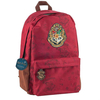
Hogwarts Crest Canvas Bag

This Harry Potter cotton tote shopper bag is perfect for carrying all the essentials, from spell books to magic wands. It features the Hogwarts crest, which shows all four houses, on the front and the Harry Potter logo on the back. The bag features shoulder straps, magnetic snap closure and a small zip pocket on the inside for valuables, printed with the Harry Potter logo.
RIP - This product is no longer available on our network. It was last seen on 25.09.2019

This page now acts as a permanent archive for this product. Add more information using the comments box below to ensure it can still be found by future generations.

Use our search facility to see if it is available from an alternative contributor.
  • External links may include paid for promotion
  • Availability: Out Of Stock
  • Supplier: Stanfords
  • SKU: 5055453448010
Availability: In Stock
£12.99

Product Description

This Harry Potter cotton tote shopper bag is perfect for carrying all the essentials, from spell books to magic wands. It features the Hogwarts crest, which shows all four houses, on the front & the Harry Potter logo on the back. The bag features shoulder straps, magnetic snap closure & a small zip pocket on the inside for valuables, printed with the Harry Potter logo.

Reviews/Comments

Add New

Intelligent Comparison

Oooops!
We couldn't find anything!
Perhaps this product's unique.... Or perhaps we are still looking for comparisons!
Click to bump this page and we'll hurry up.

Price History

Vouchers

No voucher codes found.
Do you know a voucher code for this product or supplier? Add it to Insights for others to use.

Facebook

Jargon Buster

Cotton - A natural fibre grown on cotton plants
ZIP - A device (Usualy Metal) used for temporarily attaching two pieces of fabric together
Canvas - A heavy duty plain woven fabric. Used on tents, footwear and painting
magnetic - A susbstance affected at a microscopic level by an applied magnetic field.
Small - something that takes up less space than normal.
Cotton - A 100% natural fibre coming from a cotton boll.
Logo - A symbol that is usually associated with a brand or product.
Zip - A Fastening which can open and close to get inside.
Pocket - A bag shaped insert in clothing used to carry items

Supplier Information

Stanfords
Stanfords was established in 1853 and opened their iconic Covent Garden flagship store in 1901. They have become the top retailer of maps, travel books and accessories in the UK and arguably offer the largest selection of maps and travel books worldwide. Famous names such as Captain Robert Falcon Scott, Ranulph Fiennes and Michael Palin have purchased from Stanfords. They now have a shop in Bristol and both stores together with other venues operate a calendar of events including talks, book signings and exhibitions. As a specialist map retailer, the map selection is comprehensive and includes road maps, street maps and walking maps from worldwide destinations, as well as a selection of world atlases and wall maps. Books include travel guides and travel literature. Stanfords also stock globes, from miniatures made of blue marble to magnificent floor-standing globes. The website features a selection of interesting articles on travel topics.
Page Updated: 2023-11-12 20:15:36

Community Generated Product Tags

Oh No! The productWIKI community hasn't generated any tags for this product yet!
Menu