More From Contributor

£20.00
This is the story of a fracturing family in a moment of crisis. Over the course of three weeks in present-day Washington DC, three sons watch their parents` marriage falter & their family home fall apart. Meanwhile, a larger catastrophe is engulfing another part of the world: a massive earthquake devastates the Middle East, sparking a pan-Arab invasion of Israel. With global upheaval in the background & domestic collapse in the foreground, Jonathan Safran Foer asks us
- what is the true meaning of home? Can one man ever reconcile the conflicting duties of his many roles
- husb&, father, son? & how much of life can a person bear?

...
Archived Product
£8.99
The New York Times bestselling new novel about modern family lives -- from the author of Everything Is Illuminated & Extremely Loud & Incredibly Close Jacob & Julia Bloch are about to be tested.. . By Jacob`s grandfather, who won`t go quietly into a retirement home. By the family reunion, that everyone is dreading. By their son`s heroic attempts to get expelled. & by the sexting affair that will rock their marriage.A typical modern American family, the Blochs cling together even as they are torn apart. Which is when catastrophe decides to strike.. . Confronting the enduring question of what it means to be human with inventiveness, playfulness & compassion, Here I Am is a great American family novel for our times, a masterpiece about how we live now. ...
Archived Product
£9.99
” Tim Hetherington (1970-2011) was one of the world`s most distinguished & dedicated photojournalists, whose career was tragically cut short when he died in a mortar blast while covering the Libyan Civil War. Someone far less interested in professional glory than revealing to the world the realities of people living in extremely difficult circumstances, Tim nonetheless won many awards for his war reporting, & was nominated for an Academy Award for his critically acclaimed documentary, Restrepo. Hetherington`s dedication to his career led him time after time into war zones, & unlike some other journalists, he did not pack up after the story had broken. After the civil war ended in Liberia, West Africa, Tim stayed on for three years, helping the United Nations track down human rights criminals. His commitment to getting the story out & his compassion for those affected by war was unrivalled. In Here I Am, Alan Huffman tells Hetherington`s life story, & through it analyses what it means to be a war reporter in the twenty-first century. Huffman recounts Hetherington`s life from his first interest in photography & war reporting, through his critical role in reporting the Liberian Civil War, to his tragic death in Libya. Huffman also traces Hetherington`s photographic milestones, from his iconic & prize-winning photographs of Liberian children, to the celebrated portraits of sleeping US soldiers in Afghanistan. Here I Am explores the risks, challenges, & thrills of war reporting, & is a testament to the unique work of people like Hetherington, who travel into the most dangerous parts of the world, risking their lives to give a voice to those devastated by conflict.” ...
Archived Product
£10.99
Inspired by the 800-year anniversary of the signing of the Magna Carta, a selection of writers explore the rights & freedoms still lacking in today`s society. Contributors include: Tony Birch, John Boyne, Sita Brahmachari, Russell Br&, Kate Charlesworth, Sarah Crossan, Neil Gaiman, Jack Gantos, Matt Haig, Frances Hardinge, Jackie Kay, AL Kennedy, Liz Kessler, Elizabeth Laird, Sabrina Mahfouz, Paul Muldoon, Chibundu Onuzo, Bali Rai, Chris Riddell, Mary & Brian Talbot, Christie Watson & Tim Wynne-Jones. ...
Archived Product
£14.99
Shortlisted for a 2018 Edward Stanford Travel Writing Award. The exquisite & thought-provoking new book from the multi award-winning, internationally best-selling picture book creator of Lost & Found, Oliver Jeffers. Well, hello. & welcome to this Planet. We call it Earth. Our world can be a bewildering place, especially if you`ve only just got here. Your head will be filled with questions, so let`s explore what makes our planet & how we live on it. From land & sky, to people & time, these notes can be your guide & start you on your journey. & you`ll figure lots of things out for yourself. Just remember to leave notes for everyone else... Some things about our planet are pretty complicated, but things can be simple, too: you`ve just got to be kind. Here We Are is the utterly heartfelt new book from Oliver Jeffers. We`re glad you found it. ...
Archived Product
£6.99
Sing along with Fred Penner as you follow four children from different countries, each going through their early morning routine & getting ready for school. See what the pictures tell you about different ways of life in the UK, Africa, India & China. This is the latest from Fred Penner, the voice behind The Animal Boogie (PB w/ CD: 978-1-90523-622-0) which has sold more than 550, 000 copies worldwide! Children will recognise their own familiar routine as they learn about the rituals of other cultures. ' This multicultural treat will encourage creative movement as well as creativity in inventing other verses for preschoolers'
- School Library Journal. Sing & dance along to the classic song
- a favourite in classrooms & at home!

...
Archived Product
£6.39
A detailed topographic map from the Ordnance Survey Explorer series, covering Hereford & Ross-on-Wye. Edition A2; Publication date July 2009 About this series: These highly detailed maps show all the administrative boundaries, settlements as small as isolated farms, the road network down to unfenced roads & country tracks, & field boundaries (hedges & drystone walls) which make navigation across the countryside much easier. Steep gradients on roads are indicated. Various landmarks, e.g. powerlines, archaeological sites, windmills, churches & lighthouses are shown & additional graphics indicate natural terrain features such as cliffs, scree, mud & vegetation variations. The contour interval is 5 metres in the lower parts of the country & 10 metres in the uplands, & spot heights are marked. Each map covers an area of 30 x 20km (i.e. approx. 19 x 12 miles), with some double-sided maps covering more, as indicated in the individual descriptions. The maps are fully GPS compatible, with the National Grid shown at 1km intervals & latitude & longitude indicated by margin ticks at 1'. The Explorer series has replaced the earlier, green-cover Pathfinder maps. The Explorer series is now complete & covers all of Engl&, Wales & Scotl&. Some sheets for popular areas like the National Parks are still branded as Outdoor Leisure (OL) maps, but are now included in this series as the cartography is the same as that in the Explorer Maps. The Explorer maps offer a substantial improvement on the Pathfinder series, with greater use of colour, larger area per map, & stronger emphasis on information for ramblers & tourists. This series is ideal for walking & other outdoor pursuits & each map shows a large amount of information for ramblers & tourists. Public rights of way are shown (except in Scotland), together with other routes with public access: National Trails & Recreational Paths, permitted paths & bridleways, & selected cycle routes. Open access land created under the Countryside & Rights of Way Act 2000 is marked. Tourist information

Includes::
caravan & camp sites, Park & Ride locations, recreation/leisure/sport centres, museums, historic buildings, English Heritage & National Trust sites, rural pubs, etc. The map legend is in English only, except for the tourist information content which is also in French & German.

...
Archived Product
£11.19
Laminated waterproof edition of a detailed topographic map from the Ordnance Survey Explorer series, covering Hereford & Ross-on-Wye. Edition A2; Publication date July 2009 About this series: These highly detailed maps show all the administrative boundaries, settlements as small as isolated farms, the road network down to unfenced roads & country tracks, & field boundaries (hedges & drystone walls) which make navigation across the countryside much easier. Steep gradients on roads are indicated. Various landmarks, e.g. powerlines, archaeological sites, windmills, churches & lighthouses are shown & additional graphics indicate natural terrain features such as cliffs, scree, mud & vegetation variations. The contour interval is 5 metres in the lower parts of the country & 10 metres in the uplands, & spot heights are marked. Each map covers an area of 30 x 20km (i.e. approx. 19 x 12 miles), with some double-sided maps covering more, as indicated in the individual descriptions. The maps are fully GPS compatible, with the National Grid shown at 1km intervals & latitude & longitude indicated by margin ticks at 1'. The Explorer series has replaced the earlier, green-cover Pathfinder maps. The Explorer series is now complete & covers all of Engl&, Wales & Scotl&. Some sheets for popular areas like the National Parks are still branded as Outdoor Leisure (OL) maps, but are now included in this series as the cartography is the same as that in the Explorer Maps. The Explorer maps offer a substantial improvement on the Pathfinder series, with greater use of colour, larger area per map, & stronger emphasis on information for ramblers & tourists. This series is ideal for walking & other outdoor pursuits & each map shows a large amount of information for ramblers & tourists. Public rights of way are shown (except in Scotland), together with other routes with public access: National Trails & Recreational Paths, permitted paths & bridleways, & selected cycle routes. Open access land created under the Countryside & Rights of Way Act 2000 is marked. Tourist information

Includes::
caravan & camp sites, Park & Ride locations, recreation/leisure/sport centres, museums, historic buildings, English Heritage & National Trust sites, rural pubs, etc. The map legend is in English only, except for the tourist information content which is also in French & German.

...
Archived Product
£8.99
Hereford & Ross-on-Wye area on a detailed topographic & GPS compatible map No. 189, paper version, from the Ordnance Survey’s 1:25, 000 Explorer series. MOBILE DOWNLOADS: this title & all the other OS Explorer maps include a code for downloading after purchase the digital version onto your smartphone or tablet for viewing on the OS smartphone app.OS EXPLORER SERIES: to see the list of all the titles in the OS Explorer series, both paper & waterproof versions, please click on the series link. The Explorer series, Ordnance Survey’s most detailed maps recommended for anyone enjoying outdoor activities, provides topographic coverage of Great Britain at 1:25, 000 on GPS compatible maps with hiking trails, cycling routes & extensive tourist information. Each printed map is available either on paper or as a waterproof & tear-resistant OS Active Map, as indicated in its title. Britain’s National Parks & other areas of particular tourist interest are presented on often double-sided OL (Outdoor Leisure) maps, whilst most standard format Explorers cover an area of 30 x 20km (approx. 19 x 12 miles). All three versions (paper, waterproof & digital) are the same & provide plenty of recreational & tourist information, indicating the traditional public right of way paths (except in Scotland where different laws apply), including bridleways & byways. National Trails & other long-distance paths are marked, as well as permissive footpaths or bridleways & on-road or traffic-free cycle routes with, where appropriate, their National/ Regional Cycle Network numbers. Boundaries of access land are clearly marked. A wide range of symbols provides additional tourist information, highlighting camping & caravanning sites, information offices & visitors’ centres, parking & picnicking places, country pubs, sport & recreational facilities including cycle hire locations & mountain biking trails, historic buildings & museums, etc. Exceptionally clear presentation of the landscape is provided by contours at 5m or in the uplands at 10m intervals, with additional spot heights plus colouring and/or graphics for different types of woodlands, orchards, heath, marshl&, scree or boulders, & other topographic features. For GPS users the maps have British National Grid lines at 1km intervals, with latitude & longitude given by margin ticks at 1`. Clearly laid out map legend

Includes::
French & German translations for the tourist information symbols.

...
Archived Product

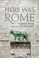
Here Was Rome: Modern Walks In The

This book provides a coherent story behind the sites of Rome, to lead the reader on a journey through the turbulent history of the Roman state from its humble beginnings on the Palatine hill to the maximum extent of its power in the 1st-2nd centuries A D, when almost the whole world known to the Romans was under their control. Firmly rooted in the topographic and architectural realities of today, the book will strive to give the sites a meaning and to connect them with the people who lived, fought and loved there two thousand years ago. It serves both as a framework for a visit to Rome, taking in the sites in chronological order so that the history unfolds on the journey; or for the armchair traveller who will enjoy the mix of informed description, colourful anecdote and historical
knowledge based on the author`s lifetime of fascination with the Roman Empire.
RIP - This product is no longer available on our network. It was last seen on 25.09.2019

This page now acts as a permanent archive for this product. Add more information using the comments box below to ensure it can still be found by future generations.

Use our search facility to see if it is available from an alternative contributor.
  • Availability: Out Of Stock
  • Supplier: Stanfords
  • SKU: 9781911072010
Availability: In Stock
£14.99

Product Description

This book provides a coherent story behind the sites of Rome, to lead the reader on a journey through the turbulent history of the Roman state from its humble beginnings on the Palatine hill to the maximum extent of its power in the 1st-2nd centuries A D, when almost the whole world known to the Romans was under their control. Firmly rooted in the topographic & architectural realities of today, the book will strive to give the sites a meaning & to connect them with the people who lived, fought & loved there two thousand years ago. It serves both as a framework for a visit to Rome, taking in the sites in chronological order so that the history unfolds on the journey; or for the armchair traveller who will enjoy the mix of informed description, colourful anecdote & historical knowledge based on the author`s lifetime of fascination with the Roman Empire.

Reviews/Comments

Add New

Intelligent Comparison

Oooops!
We couldn't find anything!
Perhaps this product's unique.... Or perhaps we are still looking for comparisons!
Click to bump this page and we'll hurry up.

Price History

Vouchers

No voucher codes found.
Do you know a voucher code for this product or supplier? Add it to Insights for others to use.

Facebook

Jargon Buster

History - Anything that happens in the past. An acedemic subject.
World - A physical grouping, commonly used to describe earth and everything associated with ti

Supplier Information

Stanfords
Stanfords was established in 1853 and opened their iconic Covent Garden flagship store in 1901. They have become the top retailer of maps, travel books and accessories in the UK and arguably offer the largest selection of maps and travel books worldwide. Famous names such as Captain Robert Falcon Scott, Ranulph Fiennes and Michael Palin have purchased from Stanfords. They now have a shop in Bristol and both stores together with other venues operate a calendar of events including talks, book signings and exhibitions. As a specialist map retailer, the map selection is comprehensive and includes road maps, street maps and walking maps from worldwide destinations, as well as a selection of world atlases and wall maps. Books include travel guides and travel literature. Stanfords also stock globes, from miniatures made of blue marble to magnificent floor-standing globes. The website features a selection of interesting articles on travel topics.
Page Updated: 2023-11-12 20:15:36

Community Generated Product Tags

Oh No! The productWIKI community hasn't generated any tags for this product yet!
Menu