More From Contributor
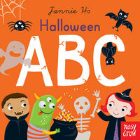
£11.50
Topographic survey of France at 1:25, 000 in IGN`s excellent TOP25 / Série Bleue series. All the maps are GPS compatible, with a 1km UTM grid plus latitude & longitude lines at 5’ intervals. Contours are at 5m intervals except for mountainous areas where the maps have contours at 10m intervals, vividly enhanced by hill shading & graphics for rocky terrain. Colouring with graphics indicates different types of vegetation or land use (deciduous or coniferous forests, moors, orchards, vineyards, etc). PLEASE NOTE: coverage of France at this scale is currently being revised – the format & the presentation of each title are indicated by the letters at the end of its Sheet Reference number (e.g. 0416ET, 3531ETR, 1923SB, etc.)MAPS WITH FULL TOURIST OVERPRINT & AN ENGLISH MAP LEGEND: all TOP25 maps & the SB editions of Série Bleue have an overprint highlighting waymarked walking trails including long-distance GR routes &, where appropriate, ski routes. Symbols indicate campsites, gîtes d’etape, refuges, equestrian centres & other recreational facilities or sites, tourist information centres, cultural heritage, etc. Towns & locations of particular interest are highlighted.- ET or OT = single-sided TOP25 map covering approx. 29x 21 km / 18x 13 miles.- ETR or OTR = waterproof & tear resistant TOP25 map covering the same area as the corresponding ET or OT number, but double-sided, printed on a smaller size sheet with a good overlap between the sides.- SB = Série Bleue map with full tourist overprint; these maps, first introduced in summer 2014, each cover approx. 29x 24km / 18x 15 miles.SÉRIE BLEUE maps with numbers ending in E (Est) or O (Ouest): most editions now indicate the GR routes, but do not show any other tourist information. Map legend is in French only. Each map covers approx. 14x 20km / 9x 12 miles. ...
Archived Product
£25.00
Keenly anticipated each year by winemakers, collectors & wine lovers, the ” Australian Wine Companion” is recognized nationally as the industry benchmark. The 2016 edition has been completely revised to bring you up-to-the-minute information. In his inimitable style, Halliday shares his extensive knowledge of wine through detailed tasting notes, each with vintage-specific ratings, alcohol content & price, advice on optimal drinking as well as individual information on the wineries & winemakers. The ” Australian Wine Companion ”is an indispensable reference from the country s leading wine authority.” ...
Archived Product
£20.00
The Halliday Wine Companion is recognised as the industry benchmark for Australian wine. The 2019 edition has been completely revised to bring you up-to-the-minute information. In his inimitable style, Halliday shares his extensive knowledge of wine through detailed tasting notes with points, price, value symbol & advice on best-by drinking, as well as each wine`s closure & alcohol content. He provides information about wineries & winemakers, including vineyard sizes, opening times & contact details. ...
Archived Product
£23.99
Hallingskarvet area of the Hardangervidda region in Norway in a series of GPS compatible recreational maps at 1:50, 000 with cartography from Norway’s topographic survey & additional tourist information. Contours lines are drawn at 20m intervals. The overprint varies from title to title, but

Includes::
local footpaths, in some cases distinguishing between easy & more difficult trails, as well as mountain huts & campsites. Many titles also indicate cycle or ski routes, other accommodation possibilities, sport & recreational facilities, including alpine skiing slopes, places of interest, etc. The maps have a UTM grid & margin ticks giving latitude & longitude. Map legend

Includes::
English. Several titles have on the reverse additional tourist information, although in most cases in Norwegian only.PLEASE NOTE: this title is also available as a set of two maps which

Includes::
the Geilo map. To see the list of Turkart maps at 1:50, 000 & links to Turkart series at 25K, 100K & Hiking Sets please click on the series link above.


...
Archived Product
£25.99
Topo 3000 Hallingskarvet National Park by Nordeca AS is a detailed map covering over 3000km 2. Easy to find hiking routes & lodgings in the area. In addition to covering Hallingskarvet, the map is ideal for riding in Rallarvegen, hiking in Aurlandsdalen, glacier walking on Hardangerjøkulen or hiking from cabin to cabin starting from Hallingskeid or Finse. ...
Archived Product
£15.00
Join exotic animals for a magical night of Trick-or-Treating at the Zoo! This amazing pop-up book is filled with unique combinations of pop-ups, humour & unexpected surprises. Halloween at the Zoo is the first book from Jumping Jack Press, a division of Up With Paper, the world`s leading pop-up greeting card company. ...
Archived Product
£7.99
A teenage murder witness is drowned in a tub of apples... At a Hallowe`en party, Joyce
- a hostile thirteen-year-old
- boasts

...
Archived Product
£16.99
Topographic survey of Sweden at 1:50, 000, the Terrängkartan, from the Lantmäteriet, covering most of the country in 244 double-sided maps. Please note: the mountainous regions of central & northern Sweden are not covered by this series but presented in a separate “ Fjällkartan
- Mountain Map” series also listed on our website. Each 1:50, 000 topographic survey map covers an area of 37.5 x 40km. The maps have contours at 5 metre intervals, plus relief shading & graphics for rocky outcrops & boulders. Further graphics and/or colouring show different types of land use or vegetation (forests, arable l&, orchards, marshes, peat bogs, etc). An unusual feature of this survey is the colouring indicating buildings below or above two storeys high & “leisure/holiday homes”. The maps indicate privately maintained roads & include all other information expected of topographic survey at this scale. The maps have a 1-km UTM grid, plus latitude & longitude lines 5’ intervals. Map legend

Includes::
English. For coverage of the country’s most visited hiking areas in central & northern Sweden please see Lantmäteriet’s Mountain Map series, listed separately on our website.


...
Archived Product

Halloween ABC

Fun first alphabet books for babies and toddlers, this new series of sturdy board books also introduces simple seasonal words, to get toddlers excited about Halloween. As well as first letter sounds to say out loud, there are bright pictures featuring lots of happy faces, and familiar spooky details to spot and talk about, providing hours of shared first word fun!
RIP - This product is no longer available on our network. It was last seen on 25.09.2019

This page now acts as a permanent archive for this product. Add more information using the comments box below to ensure it can still be found by future generations.

Use our search facility to see if it is available from an alternative contributor.
  • External links may include paid for promotion
  • Availability: Out Of Stock
  • Supplier: Stanfords
  • SKU: 9780857637598
Availability: In Stock
£5.99

Product Description

Fun first alphabet books for babies & toddlers, this new series of sturdy board books also introduces simple seasonal words, to get toddlers excited about Halloween. As well as first letter sounds to say out loud, there are bright pictures featuring lots of happy faces, & familiar spooky details to spot & talk about, providing hours of shared first word fun!

Reviews/Comments

Add New

Intelligent Comparison

Oooops!
We couldn't find anything!
Perhaps this product's unique.... Or perhaps we are still looking for comparisons!
Click to bump this page and we'll hurry up.

Price History

Vouchers

No voucher codes found.
Do you know a voucher code for this product or supplier? Add it to Insights for others to use.

Facebook

Jargon Buster

Sounds - Audible notes that can be heard using ears
Fun - Something that provides amusement or enterainment
Simple - Basic, easy no difficulty in understanding.
Sturdy - something hat is very stable and is solidly built.

Supplier Information

Stanfords
Stanfords was established in 1853 and opened their iconic Covent Garden flagship store in 1901. They have become the top retailer of maps, travel books and accessories in the UK and arguably offer the largest selection of maps and travel books worldwide. Famous names such as Captain Robert Falcon Scott, Ranulph Fiennes and Michael Palin have purchased from Stanfords. They now have a shop in Bristol and both stores together with other venues operate a calendar of events including talks, book signings and exhibitions. As a specialist map retailer, the map selection is comprehensive and includes road maps, street maps and walking maps from worldwide destinations, as well as a selection of world atlases and wall maps. Books include travel guides and travel literature. Stanfords also stock globes, from miniatures made of blue marble to magnificent floor-standing globes. The website features a selection of interesting articles on travel topics.
Page Updated: 2023-11-12 20:15:36

Community Generated Product Tags

Oh No! The productWIKI community hasn't generated any tags for this product yet!
Menu