More From Contributor

£4.50
Gujarat in a series of waterproof & tear-resistant maps from Bharat Graphics, showing local districts in different colours & indicating both administrative headquarters of each district & of its subdivisions, the tehsils (or tahsils, tahasils, talukas, taluks, taluqs). Roads are classified as national or state highways & other roads, some with driving distances. Railway lines are also marked & some titles have symbols indicating places of interest or rest houses. Maps of states in mountainous areas show names of main valleys, on other titles there is no topographic information. The maps have no geographical coordinates. Some titles include insets with enlargements of popular areas or street plans, & distance tables. All the maps are indexed & have a small booklet providing a basic guide to the state district by district. The maps are printed on a waterproof & tear-resistant paper. Please note: the various series of state maps of India often show different small villages, supplementing each other to provide a more detail picture of each state. ...
Archived Product
£7.50
Indian state of Gujarat, on road map from the Delhi-based International Publications, showing many small towns & villages. Please note that, unlike most other titles in this series, this one comes without an accompanying booklet. Additional features around the main map include a physical maps of the state, plus small maps showing annual rainfall, cash crops & industry, plus a distance chart & a facts-&-figures table. Unless indicated to the contrary in the individual description, maps in this series present the state with its constituent districts in different colours & also show the division of districts into talukas. Town symbols indicate both district & taluka headquarters. Road network

Includes::
many local roads, some with driving distances, although sometimes locations are marked without road access to them shown on the map. Railway lines are included & local airports are marked. Symbols indicate various locations of interest, including historical sites, wildlife sanctuaries, beaches, etc. In many titles additional panels around the main map and/or in the accompanying booklet provide more information: enlargements with more detailed presentation of the road network, street plans of main cities, etc. To see the list of titles in this series please click on the series link.

...
Archived Product
£4.95
Road atlas of the state with maps arranged by administrative districts. Road information gives distances but does not indicate the type of road surface. The maps show railway lines, places of interest such as hill stations, beaches, historical & religious centres, etc. The atlas also contains rather basic street plans of main towns, indicating important public buildings, monuments, etc. Brief descriptions of each district include details of population, literacy, etc. ...
Archived Product
£17.95
Gujranwala on a large indexed plan with names of districts, colonies & main streets. The plan names various public buildings, industrial & agricultural establishments, etc. & marks locations of religious buildings of various denominations, hotels & rest houses & petrol stations, etc. On the reverse is index, details of railway connections to the city, lists of hotels & restaurants, etc., & dialing codes for various Pakistani towns. ...
Archived Product
£9.95
The monuments of Gulbarga, Bidar & Bijapur in northern Karnataka, once part of a vibrant culture that flourished under the Bahmani & Adil Shahi sultans during the 14th to 17th centuries, are among the less visited sites within the state but still include many interesting temples & other monuments. This illustrated guide published in cooperation with the Deccan Heritage Foundation, fill a useful gap with its informative text, numerous colour photos, & site plans. ...
Archived Product
£12.99
The Gulf Country spanning the western coastline of Queensland & the north-eastern part of Northern Territory on a GPS compatible map at 1:1, 500, 00 from Westprint, with on the reverse descriptions of the region’s 34 best sights plus other useful tourist information. Coverage extends from the south-western coast of Cape York to Katherine in the north-western corner of the map, & south to Mount Isa on the Barkly Highway. Other main routes include the Stuart Highway between the Davenport Range & Katherine, the Great Top Road, the Tablelands Highway, etc. Road network indicates unsealed routes, 4WD tracks, private tracks requiring entry permits, driving distances on most routes, grids & gates, etc. 21 locations are annotated with their GPS waypoints & symbols indicate fuel supplies, campsites/caravan parks, rest areas, Desert Parks Pass Agency offices, etc, Also marked are routes of Australia’s early explorers. Topography is indicated by relief shading, with colouring to national parks/protected areas & Aboriginal Lands. Numerous small rivers, creeks & lakes are named. Several locations are annotated with brief descriptions. In addition to the GPS waypoints the map has latitude & longitude lines at 1º intervals, with margin ticks at 10’. On the reverse are tourist tips, including description of 34 recommended sights grouped along the Stuart Highway, the Great Top Road & the Barkly Highway. ...
Archived Product
£9.99
Gulf Islands
- Nanaimo & Islands at 1:50, 000 in a series of topographic survey maps of selected areas of British Columbia & the
...
Archived Product
£40.00
Official Mexican Hydrographic Office charts (SEMAR
- Secretaría de Marina Armada de México) offer a great range of scales for ports
...
Archived Product
£9.99
The Gulf of Oristano area in a series of contoured, GPS compatible maps at 1:60, 000 from Ed. Abies, with extensive tourist information including special recreational routes plus additional coverage at more detailed scales of selected popular areas.* Main series at 1:60, 000 (Nos. 1 to 12)* The maps have contours at 100m intervals & colouring for woodlands & maquis shrubl&. Local trails are highlighted, with additional overprint for selected hiking, mountain bike & kayaking routes listed on the reverse of the maps with brief notes & grading for the degree of difficulty. All the maps have a UTM grid for GPS users. Very extensive range of symbols highlight numerous places of interest & tourist facilities, including campsites & caravan parks, beaches, sport & recreational sites, archaeological remains & nuraghi, etc. The maps also indicate places where typical local products can be purchased. On the reverse each title has descriptions of its main places of interest, beaches, etc.* More detailed maps at 1:25, 000/1:30, 000 (Nos. 3A to 12A)* Contour interval is 25m, plus colouring for vegetation. Local trails are marked but unless indicated in the individual description, special routes are not included. Tourist overprint is also less extensive than on the 1:60, 000 maps. Most titles have GPS coordinates. On the reverse are extensive notes describing the area. For more details see individual descriptions. * Map legend & additional text on all the maps

Includes::
English.*

...
Archived Product

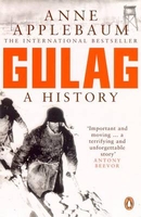
Gulag: A History Of The Soviet Camps

This landmark book uncovers for the first time in detail one of the greatest horrors of the twentieth century: the vast system of Soviet camps that were responsible for the deaths of countless millions. ”Gulag” is the only major history in any language to draw together the mass of memoirs and writings on the Soviet camps that have been published in Russia and the West. Using these, as well as her own original research in NKVD archives and interviews with survivors, Anne Applebaum has written a fully documented history of the camp system: from its origins under the tsars, to its colossal expansion under Stalin`s reign of terror, its zenith in the late 1940s and eventual collapse in the era of glasnost. It is a gigantic feat of investigation, synthesis and moral reckoning.
RIP - This product is no longer available on our network. It was last seen on 25.09.2019

This page now acts as a permanent archive for this product. Add more information using the comments box below to ensure it can still be found by future generations.

Use our search facility to see if it is available from an alternative contributor.
  • Availability: Out Of Stock
  • Supplier: Stanfords
  • SKU: 9780140283105
Availability: In Stock
£12.99

Product Description

This landmark book uncovers for the first time in detail one of the greatest horrors of the twentieth century: the vast system of Soviet camps that were responsible for the deaths of countless millions. ” Gulag” is the only major history in any language to draw together the mass of memoirs & writings on the Soviet camps that have been published in Russia & the West. Using these, as well as her own original research in NKVD archives & interviews with survivors, Anne Applebaum has written a fully documented history of the camp system: from its origins under the tsars, to its colossal expansion under Stalin`s reign of terror, its zenith in the late 1940s & eventual collapse in the era of glasnost. It is a gigantic feat of investigation, synthesis & moral reckoning.

Reviews/Comments

Add New

Intelligent Comparison

Oooops!
We couldn't find anything!
Perhaps this product's unique.... Or perhaps we are still looking for comparisons!
Click to bump this page and we'll hurry up.

Price History

Vouchers

No voucher codes found.
Do you know a voucher code for this product or supplier? Add it to Insights for others to use.

Facebook

Jargon Buster

History - Anything that happens in the past. An acedemic subject.
Language - the method of communication used in different areas. Humans and computers have many different languages.
Language - The way humans communicate either written and spoken.

Supplier Information

Stanfords
Stanfords was established in 1853 and opened their iconic Covent Garden flagship store in 1901. They have become the top retailer of maps, travel books and accessories in the UK and arguably offer the largest selection of maps and travel books worldwide. Famous names such as Captain Robert Falcon Scott, Ranulph Fiennes and Michael Palin have purchased from Stanfords. They now have a shop in Bristol and both stores together with other venues operate a calendar of events including talks, book signings and exhibitions. As a specialist map retailer, the map selection is comprehensive and includes road maps, street maps and walking maps from worldwide destinations, as well as a selection of world atlases and wall maps. Books include travel guides and travel literature. Stanfords also stock globes, from miniatures made of blue marble to magnificent floor-standing globes. The website features a selection of interesting articles on travel topics.
Page Updated: 2023-11-12 20:15:36

Community Generated Product Tags

Oh No! The productWIKI community hasn't generated any tags for this product yet!
Menu