More From Contributor
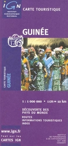
£10.99
` Life for De Quincey was either angels ascending on vaults of cloud or vagrants shivering on the city streets.` Thomas De Quincey
-
...
Archived Product
£6.50
Topographic coverage of the Canary Islands at 1:25, 000 published by the Instituto Geográfico Nacional – Centro Nacional de Información Geografica, the country’s civilian survey organization. The maps have contours at 10m intervals & colouring and/or graphics to show different types of vegetation or land use. Boundaries of national parks & other protected areas are marked. In addition to all the usual information shown on topographic mapping at this scale: detailed presentation of the road network with rural tracks & paths, etc, the maps also show campsites. The maps have a 1-km UTM grid, plus margin ticks for latitude & longitude at 1` intervals. The majority of the titles have been published since late 1990s. Map legend is in Spanish only.COVERAGE: each 25K map covers one quarter of the corresponding 1:50, 000 map, with the numbering system: I = NW quarter, II = NE quarter, III = SW quarter, & IV = SE quarter. To see other titles in this series please click on the series link. ...
Archived Product
£15.95
A detailed, colour survey map from the Portuguese Military Survey's M782 series. Each map in this series has contours at 20m intervals with supplementary contours at 10m intervals. One major advantage the military mapping has over the civilian equivalent is that the legend is in English as well as Portuguese. This legend

Includes::
roads, railways, buildings, spot heights, vegetation type, fluvial information, scree, dunes, churches, ruins, etc. Latitude & longitude ticks are show at 10' intervals. Recently revised sheets also have a UTM grid at 100m intervals. Vertical Datum: Mean Sea Level at Cascais Harbour Projection: Transverse Mercator

...
Archived Product
£17.99
Topographic survey of Portugal at 1:50, 000 from the Instituto Geográfico do Exército, the country’s military survey organisation. The maps have contours at 20m intervals & in addition to the standard features shown on topographic mapping at this scale also indicate various types of terrain or vegetation (s&, terraces, rocks, woodlands, vineyards, etc). Each sheet covers an area of 32 x 20km (20 x 12.5 miles approx). The maps have a 1-km UTM grid plus latitude & longitude coordinates for the map corners. Map legend & a glossary of terms used on the maps include English.EDITION DATES: most titles in this series date from 1990s or later. To see all the titles in this series please click on the series link. ...
Archived Product
£17.99
Topographic survey of Portugal at 1:50, 000 from the Instituto Geográfico Português, the country’s civilian survey organisation. The maps have contours at 25m intervals & in addition to the standard features shown on topographic mapping at this scale also indicate various types of vegetation (vineyards, olive groves, etc). Each sheet covers an area of 32 x 20km (20 x 12.5miles approx). The maps have latitude & longitude margin ticks at 1’ intervals & UTM coordinates for the map corners – each sheet also shows conversion details from BBLx (Bessel-Bonnie system, Datum Lisbon) to UTM. Map legend is in Portuguese only.EDITION DATES: most titles in this series have now been updated in the 1990s or later. To see all the titles in this series please click on the series link. ...
Archived Product
£10.95
A general map of the country with an inset showing the central part of Bissau. The map shows various types of terrain; mangroves, forests, the savana, rice fields, etc., as well as mineral resources (bauxite & phosphate). Road network

Includes::
seasonal roads & shows petrol stations & intermediate driving distances. The map also indicates post offices, medical facilities, places of interest, selected tourist accommodation, etc. Insets show a street plan of central Bissau at 1:20, 000 & the country's administrative boundaries. Latitude & longitude are marked at 1

...
Archived Product
£14.95
Map No. L-1B in the TPC series: military topographic survey mapping covering the world's land masses & significant islands at 1:500, 000. The maps are useful as general topographical coverage where nothing else is available, although they are designed primarily as flying charts for military aircraft. TPC stands for Tactical Pilotage Chart. Relief is portrayed by a combination of contours (basic interval 500ft, intermediate contours shown where appropriate), elevation tinting & relief shading, plus spot heights. Towns, villages, major roads, railways & airports are shown but please note that many of the smaller settlements are not named & the road information is not necessarily up to date, as compilation & revision dates vary. Some air navigation information also appears on the map, such as radio beacons & restricted flying zones. Each TPC chart has both UTM & latitude/longitude grids overprinted on it, with additional margin ticks. IMPORTANT
- PLEASE NOTE: The series is gradually being withdrawn from sale to the general public & some sheets may no longer be available when ordered by us. Due to the nature of the map projection assembling these sheets to make a larger map is not recommended. in addition, colours used for relief are not constant throughout the series. In some areas of central Africa & South America the maps have blank spaces, reflecting localized deficiencies or inconsistencies in the survey data.
...
Archived Product
£12.99
Topographic survey of France at 1:25, 000 in IGN`s excellent TOP25 / Série Bleue series. All the maps are GPS compatible, with a 1km UTM grid plus latitude & longitude lines at 5’ intervals. Contours are at 5m intervals except for mountainous areas where the maps have contours at 10m intervals, vividly enhanced by hill shading & graphics for rocky terrain. Colouring with graphics indicates different types of vegetation or land use (deciduous or coniferous forests, moors, orchards, vineyards, etc). PLEASE NOTE: coverage of France at this scale is currently being revised – the format & the presentation of each title are indicated by the letters at the end of its Sheet Reference number (e.g. 0416ET, 3531ETR, 1923SB, etc.)MAPS WITH FULL TOURIST OVERPRINT & AN ENGLISH MAP LEGEND: all TOP25 maps & the SB editions of Série Bleue have an overprint highlighting waymarked walking trails including long-distance GR routes &, where appropriate, ski routes. Symbols indicate campsites, gîtes d’etape, refuges, equestrian centres & other recreational facilities or sites, tourist information centres, cultural heritage, etc. Towns & locations of particular interest are highlighted.- ET or OT = single-sided TOP25 map covering approx. 29x 21 km / 18x 13 miles.- ETR or OTR = waterproof & tear resistant TOP25 map covering the same area as the corresponding ET or OT number, but double-sided, printed on a smaller size sheet with a good overlap between the sides.- SB = Série Bleue map with full tourist overprint; these maps, first introduced in summer 2014, each cover approx. 29x 24km / 18x 15 miles.SÉRIE BLEUE maps with numbers ending in E (Est) or O (Ouest): most editions now indicate the GR routes, but do not show any other tourist information. Map legend is in French only. Each map covers approx. 14x 20km / 9x 12 miles. ...
Archived Product
£4.99
From the amazing to the bizarre to the downright unbelievable! New for 2016, this set of 52 official records cards is sure to astound your senses
- & your friends! These crazy records & astounding feats of human endeavour, combined with amazing, jaw-ping photographs, are sure to make your hair stand on end. Large format, matt laminated cards which can also be used as playing cards.
...
Archived Product
£20.00
The record-breaking records annual is back & packed with more incredible accomplishments, stunts, cutting-edge science & amazing sporting achievements than ever before. With more than 3, 000 new & updated records & 1, 000 eye-popping photos, it has thousands of new stats & facts & dazzling new features. There is so much to explore inside. Go on a whirlwind tour of the planet`s most amazing places, from the largest swamps to the deepest points on Earth. Find out what happens when you give an octopus a Rubik`s Cube, & why all you need to defend yourself from a crocodile is a rubber band! You`ll also find all your favourite records & categories such as Big Stuff, Collections, Mass Participation & Fun with Food, plus the year`s most significant sporting achievements. Our editors have also taken inspiration this year from the world of superheroes
- both fictional & real-world
- so look out for our feature chapter charting your favourite caped crusaders in comic books, TV shows & movies. We also meet the real-life record-breakers with genuine superpowers, such as the Canadian strongman vicar who can pull a jumbo jet & an actual cyborg who uses technology to augment his senses. You`ll also learn all about the science of superheroes, such as who the fastest & strongest superheroes would be if they came to life, & who would win in a royal rumble between Superman, Batman, Hulk & Dr Strange! Also new this year is a celebration of the superlative with infographic poster pages that explore the most exciting absolutes, such as the longest, tallest, fastest & heaviest. Does the longest sofa outstretch the longest train? Is the tallest Easter egg bigger than the tallest snowman? Find out in this amazing new edition. You`ll also find these special pages available as free poster downloads at guinnessworldrecords.com! From science to showbiz via stunts & sports, there are real-life heroes all around us in all shapes & sizes, achieving the extraordinary every day. There`s only one book where you`ll find so many amazing facts all in one place, & that`s Guinness World Records 2018!

...
Archived Product

Guinea

Colourful map with topography shown by countours, elevation colouring, and spot heights. Road network includes seasonal roads and tracks, indicating petrol stations and intermediate distances on major roads. The map also shows places of interest, forest reserves, post offices, medical facilities, selected accommodation, etc. Extensive index includes geographical features and places of interest. An inset shows the administrative divisions of the country. Latitude and longitude are marked at 1° intervals. The legend is in French only.
RIP - This product is no longer available on our network. It was last seen on 25.09.2019

This page now acts as a permanent archive for this product. Add more information using the comments box below to ensure it can still be found by future generations.

Use our search facility to see if it is available from an alternative contributor.
  • External links may include paid for promotion
  • Availability: Out Of Stock
  • Supplier: Stanfords
  • SKU: 3282118500314
Availability: In Stock
£10.99

Product Description

Colourful map with topography shown by countours, elevation colouring, & spot heights. Road network

Includes::
seasonal roads & tracks, indicating petrol stations & intermediate distances on major roads. The map also shows places of interest, forest reserves, post offices, medical facilities, selected accommodation, etc. Extensive index

Includes::
geographical features & places of interest. An inset shows the administrative divisions of the country. Latitude & longitude are marked at 1° intervals. The legend is in French only.

Reviews/Comments

Add New

Price History

Vouchers

No voucher codes found.
Do you know a voucher code for this product or supplier? Add it to Insights for others to use.

Facebook

Jargon Buster

Forest - A area with a high density of trees
Network - A link and communication between things. Often computers or people.
Road - a manmade lane or a path that is used to speed up travel.
Accommodation - A room in which someone can live in, for example in a hotel

Supplier Information

Stanfords
Stanfords was established in 1853 and opened their iconic Covent Garden flagship store in 1901. They have become the top retailer of maps, travel books and accessories in the UK and arguably offer the largest selection of maps and travel books worldwide. Famous names such as Captain Robert Falcon Scott, Ranulph Fiennes and Michael Palin have purchased from Stanfords. They now have a shop in Bristol and both stores together with other venues operate a calendar of events including talks, book signings and exhibitions. As a specialist map retailer, the map selection is comprehensive and includes road maps, street maps and walking maps from worldwide destinations, as well as a selection of world atlases and wall maps. Books include travel guides and travel literature. Stanfords also stock globes, from miniatures made of blue marble to magnificent floor-standing globes. The website features a selection of interesting articles on travel topics.
Page Updated: 2023-11-12 20:15:36

Community Generated Product Tags

Oh No! The productWIKI community hasn't generated any tags for this product yet!
Menu