
 United Kingdom
 France
 Germany
 Netherlands
 Sweden
 USA
USA
 Italy
Italy
 Spain
Spain
More From Contributor


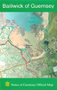
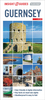
Guernsey Flexi Map
Flexi Map Guernsey is a laminated, tear-resistant map which has 5 indexed maps. It includes a list - with descriptions and some photographs - of 27 recommended sights, divided by theme and linked to the mapping by numbered markers. There is also a handy information section with concise details on getting around, tourist offices, money, tipping, opening times, public holidays, telecommunications, emergency telephone numbers and climate. The main map shows Guernsey, Herm, Alderney and Sark at a scale of 1:35 000. Its index includes over 200 points of interest such as ancient historical sites, World War II buildings, coral reefs and shipwrecks. In addition to roads and tracks, the islands' topography is shown by the use of relief shading with some spot heights given. On the
reverse, St Peter Port is depicted at 1:12 000, the accompanying index is divided into 6 categories for ease of use. Also included is an overview map of the Channel Islands and the French coast (1:800 000) on which ferry routes between the islands, France and the UK are clearly shown.
reverse, St Peter Port is depicted at 1:12 000, the accompanying index is divided into 6 categories for ease of use. Also included is an overview map of the Channel Islands and the French coast (1:800 000) on which ferry routes between the islands, France and the UK are clearly shown.
Product Description
Reviews/Comments
Add New
Vouchers
No voucher codes found.
Do you know a voucher code for this product or supplier? Add it to Insights for others to use.
Do you know a voucher code for this product or supplier? Add it to Insights for others to use.
 Denmark