More From Contributor
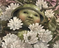
£11.95
Map No. C-13 in the ONC series: military topographic survey mapping covering the world's land masses & significant islands at 1:1, 000, 000. The maps are useful as general topographical coverage where nothing else is available, although they are designed primarily as flying charts for military aircraft. ONC stands for Operational Navigation Chart. Relief is portrayed by a combination of contours (basic interval 1000ft, intermediate contours shown where appropriate), elevation tinting & relief shading, plus spot heights. Towns, villages, major roads, railways & airports are shown but please note that many of the smaller settlements are not named & the road information is not necessarily up to date, as compilation & revision dates vary. Some air navigation information also appears on the map, such as radio beacons & restricted flying zones. Each ONC chart has both UTM & latitude/longitude grids overprinted on it, with additional margin ticks. IMPORTANT
- PLEASE NOTE: The series is gradually being withdrawn from sale to the general public & some sheets may no longer be available when ordered by us. Due to the nature of the map projection assembling these sheets to make a larger map is not recommended. in addition, colours used for relief are not constant throughout the series. In some areas of central Africa & South America the maps have blank spaces, reflecting localized deficiencies or inconsistencies in the survey data.
...
Archived Product
£14.95
Map No. C-13A in the TPC series: military topographic survey mapping covering the world's land masses & significant islands at 1:500, 000. The maps are useful as general topographical coverage where nothing else is available, although they are designed primarily as flying charts for military aircraft. TPC stands for Tactical Pilotage Chart. Relief is portrayed by a combination of contours (basic interval 500ft, intermediate contours shown where appropriate), elevation tinting & relief shading, plus spot heights. Towns, villages, major roads, railways & airports are shown but please note that many of the smaller settlements are not named & the road information is not necessarily up to date, as compilation & revision dates vary. Some air navigation information also appears on the map, such as radio beacons & restricted flying zones. Each TPC chart has both UTM & latitude/longitude grids overprinted on it, with additional margin ticks. IMPORTANT
- PLEASE NOTE: The series is gradually being withdrawn from sale to the general public & some sheets may no longer be available when ordered by us. Due to the nature of the map projection assembling these sheets to make a larger map is not recommended. in addition, colours used for relief are not constant throughout the series. In some areas of central Africa & South America the maps have blank spaces, reflecting localized deficiencies or inconsistencies in the survey data.
...
Archived Product
£12.95
Coverage of the northern coast of Greenland originally produced by the Danish survey organization Kort & Martikelstyrelsen in April 2000 & now printed by Saga Maps. The maps have contours at 100m intervals with spot heights & indicate areas covered by icecap. Local settlements, research stations, airstrips & boundaries of protected areas are marked. The maps have a latitude grid at intervals of 15’ & longitude at 1º. Map legend is in Danish only.PLEASE NOTE: although the covers of the maps show several more titles in this series, only those listed below are currently available. ...
Archived Product
£16.50
Coastal regions of Greenland at 1:500, 000 on 12 topographic maps from Saga, with coverage of the central part of the western coast also available on two special sheets at 1:370, 000. Both scales have the same cartography as the publisher’s 1:250, 000 series but reduced to provide a wider coverage per sheet. The reduction means that some place names, symbols & fine detail are harder to read than on maps in the original 1:250, 000 series. Relief is shown by contours at 50m intervals, augmented by frequent spot heights. Main peaks are named, along with many other physical features e.g. bays & islands. Glaciers, moraine & low-lying coastal plains are also indicated & contours continue for a limited extent into the icecap region. The maps show settlements, roads, airstrips & heliports, anchorages & selected other landmarks. Lines of longitude & latitude are drawn at 1° & 15` intervals respectively. Map legend is provided in a separate leaflet. ...
Archived Product
£13.95
Topographic survey of Greenland at 1:250, 000 from Sagamaps in a series which along the western coast extends past Thule to the latitude of 78°, plus covers selected areas of the east coast including the Stauning Alps. Relief is shown by contours at 50m intervals, augmented by frequent spot heights. Main peaks are named, along with many other physical features, e.g. bays & islands. Glaciers, moraine & low-lying coastal plains are also indicated & contours continue for a limited extent into the icecap region. The maps show settlements, roads, airstrips & heliports, anchorages & selected other landmarks. Lines of longitude & latitude are drawn at 1° & 15` intervals respectively. Map legend which

Includes::
English is provided in a separate sheet. Saga’s topographic mapping of Greenland at 1:250, 000 is available either as 22 smaller sheets, sold separately or in sets of four maps, plus as three larger maps covering the western coast up to approx 65°. Selected titles are also published with a historical guide on the reverse illustrated with old photos, drawings & maps; all the text is in English.

...
Archived Product
£7.99
In Greenmantle (1916), Richard Hannay, hero of The Thirty-Nine Steps, travels across war-torn Europe in search of a German plot & an Islamic Messiah. He is joined by three more of Buchan`s heroes: Peter Pienaar, the old Boer Scout; John S. Blenkiron, the American determined to fight the Kaiser; &, Sandy Arbuthnot, Greenmantle himself, modelled on Lawrence of Arabia. The intrepid four move in disguise through Germany to Constantinople & the Russian border to face their enemies: the grotesque Stumm & the evil beauty of Hilda von Einem. ...
Archived Product
£7.99
With an introduction by Christopher Hitchens. Richard Hannay is tasked to investigate rumours of an uprising in the Muslim world & takes off on a hair-raising journey through German-occupied Europe to meet up with his old friend Sandy Arbuthnot in Constantinople, where they must thwart the Germans` plans to use religion to help them win the war. Set during World War I, Greenmantle is a contraversial meditation on the power of political Islam (it was pulled from Radio 4`s schedule at the time of the 7 July bombings). ...
Archived Product
£2.50
Greenock street map from Nicolson Maps; coverage

Includes::
Gourock, Port Glasgow, Inverkip & Langbank. Nicolson

...
Archived Product
£3.50
Greenock East in 1896 in a fascinating series of reproductions of old Ordnance Survey plans in the Alan Godfrey Editions, ideal for anyone interested in the history of their neighbourhood or family. The map covers the eastern part of Greenock, stretching from West Burn Square eastward to James Watt Dock & southward to Drumfrochar Road. Features include waterfront with shipbuilding yards & timber ponds, James Watt Dock, West & East Harbour, Victoria Harbour, Garvel Graving Dock, dry dock, part of Albert Harbour, Lynedoch station, CR Greenock Branch with Cartsdyke & Cathcart Street stations, tramways, many railway sidings & dock lines, Garvel Point, Well Park, Wallace Place, part of Cartsdyke, etc. On the reverse are street directory entries, including Antigua Street, Cathcart Street, Hope Street, Ingleston Street, Lynedoch Street & St Lawrence Street. About the Alan Godfrey Editions of the 25” OS Series: Selected towns in Great Britain & Ireland are covered by maps showing the extent of urban development in the last decades of the 19th & early 20th century. The plans have been taken from the Ordnance Survey mapping & reprinted at about 15 inches to one mile (1:4, 340). On the reverse most maps have historical notes & many also include extracts from contemporary directories. Most maps cover about one mile (1.6kms) north/south, one & a half miles (2.4kms) across; adjoining sheets can be combined to provide wider coverage.FOR MORE INFORMATION & A COMPLETE LIST OF ALL AVAILABLE TITLES PLEASE CLICK ON THE SERIES LINK. ...
Archived Product
£3.50
Greenock West in 1896 in a fascinating series of reproductions of old Ordnance Survey plans in the Alan Godfrey Editions, ideal for anyone interested in the history of their neighbourhood or family. The map covers the western part of Greenock, stretching from Trafalgar Street & Crawfurd Street westward to the cemetery, & from Albert Quay southward to Drumfrochar Road. Features include part of Albert Dock, Infirmary, Cowdenknowes Reservoir, stretch of GSWR Greenock Branch with sidings & goods station by the quay; stretch of CR Gourock Extension railway with West station, Clyde Sugar Refinery, County Court Buildings, George Square, Ardgowan Square, Caddle Hill, etc. Directories for Ann Street, Bruce Street, Dempster Street & Holmscroft Street are on the reverse. About the Alan Godfrey Editions of the 25” OS Series: Selected towns in Great Britain & Ireland are covered by maps showing the extent of urban development in the last decades of the 19th & early 20th century. The plans have been taken from the Ordnance Survey mapping & reprinted at about 15 inches to one mile (1:4, 340). On the reverse most maps have historical notes & many also include extracts from contemporary directories. Most maps cover about one mile (1.6kms) north/south, one & a half miles (2.4kms) across; adjoining sheets can be combined to provide wider coverage.FOR MORE INFORMATION & A COMPLETE LIST OF ALL AVAILABLE TITLES PLEASE CLICK ON THE SERIES LINK. ...
Archived Product

Greenling

What is this growing on Barleycorn land, and is it intended for Barleycorn hands? Mr. and Mrs. Barleycorn live a quiet life, alone and forgotten by the world. But something is growing on Barleycorn land, something that Mr. Barleycorn decides it would be best to take. And with this, for better or worse, he brings the outside...inside
RIP - This product is no longer available on our network. It was last seen on 25.09.2019

This page now acts as a permanent archive for this product. Add more information using the comments box below to ensure it can still be found by future generations.

Use our search facility to see if it is available from an alternative contributor.
  • External links may include paid for promotion
  • Availability: Out Of Stock
  • Supplier: Stanfords
  • SKU: 9781783700554
Availability: In Stock
£12.99

Product Description

What is this growing on Barleycorn l&, & is it intended for Barleycorn hands? Mr. & Mrs. Barleycorn live a quiet life, alone & forgotten by the world. But something is growing on Barleycorn l&, something that Mr. Barleycorn decides it would be best to take. & with this, for better or worse, he brings the outside...inside

Reviews/Comments

Add New

Intelligent Comparison

Oooops!
We couldn't find anything!
Perhaps this product's unique.... Or perhaps we are still looking for comparisons!
Click to bump this page and we'll hurry up.

Price History

Vouchers

No voucher codes found.
Do you know a voucher code for this product or supplier? Add it to Insights for others to use.

Facebook

Jargon Buster

World - A physical grouping, commonly used to describe earth and everything associated with ti

Supplier Information

Stanfords
Stanfords was established in 1853 and opened their iconic Covent Garden flagship store in 1901. They have become the top retailer of maps, travel books and accessories in the UK and arguably offer the largest selection of maps and travel books worldwide. Famous names such as Captain Robert Falcon Scott, Ranulph Fiennes and Michael Palin have purchased from Stanfords. They now have a shop in Bristol and both stores together with other venues operate a calendar of events including talks, book signings and exhibitions. As a specialist map retailer, the map selection is comprehensive and includes road maps, street maps and walking maps from worldwide destinations, as well as a selection of world atlases and wall maps. Books include travel guides and travel literature. Stanfords also stock globes, from miniatures made of blue marble to magnificent floor-standing globes. The website features a selection of interesting articles on travel topics.
Page Updated: 2023-11-12 20:15:36

Community Generated Product Tags

Oh No! The productWIKI community hasn't generated any tags for this product yet!
Menu