More From Contributor
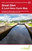
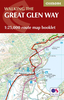
£30.00
Acclaimed writer/photgrapher team Anneli Bojstad & Eduardo Mencos look at 40 of Spain's most beautiful gardens. Large & small, historical & contemporary, classical & modern, the gardens are all very different, reflecting the diversity of Spain's climate & landscape, from the moist, green north to the dry, hot Mediterranean south. All are among the most beautiful gardens to be found in Spain today, as over 200 stunning colour photographs reveal. & all are open to the public. ...
Archived Product
£15.99
Stephen Lacey paints a vivid historical & horticultural picture of the great gardens of the National Trust. All the major periods & styles of garden design are represented, ranging from magnificent 18th century landscapes like Stowe & Croome Park, & heady Victorian creations at Biddulph Grange & Waddeston Manor, to famous plantsmen`s gardens of the last century, such as those at Hidcote Manor & Sissinghurst Castle. Glorious colour photographs complement eloquent prose to bring the gardens to life. ...
Archived Product
£1.99
Generally considered to be F. Scott Fitzgerald`s finest novel, The Great Gatsby is a consummate summary of the ”roaring twenties”, & a devastating expose of the ” Jazz Age”. Through the narration of Nick Carraway, the reader is taken into the superficially glittering world of the mansions which lined the Long Island shore in the 1920s, to encounter Nick`s cousin Daisy, her brash but wealthy husband Tom Buchanan, Jay Gatsby & the mystery that surrounds him. ...
Archived Product
£5.99
Great Glen & Loch Ness Cycle Map at 1:110, 000 from Sustrans, including The Caledonia Way, Lochs & Glens North, The North Sea cycle routes, plus two day rides: Beauly & Beyond & Black Isle Loop. Street plans show Inverness, Fort William & Dingwall. Maps is this Sustrans series show all the National & Regional Cycle Network routes clearly numbered & have the colouring distinguishing between the on-road & traffic-free sections. The publishers’ own recommendations are shown in contrasting colour &, in most titles, are in addition presented on the reverse side on separate panels where each circuit is annotated with useful notes. The maps have contours & altitude colouring to show the topography, with additional gradient markings. Towns along the routes are annotated with symbols indicating what facilities can be found there. Also marked are various places of interest, on or near the routes, & railway lines are shown with stations for access to the routes by rail. On the reverse each title also provides large, clear city centre street plans of main towns, highlighting the Cycle Network and/or the recommended routes. Also included are contact details of tourist information centres. To see the list of titles in this series please click on the series link. ...
Archived Product
£12.99
This is a complete guide to Scotland`s first formal canoe trail, the Great Glen Canoe Trail. The guide is an essential resource to help you plan your paddling journey through the Great Glen across Scotl&. As well as the calm waters of the Caledonian Canal there are the challenging open waters of Loch Lochy & Loch Ness. Here you will find advice on how to deal with the conditions as well as food, equipment, safety, communication & rescue. The best craft for the adventure are open canoes, sea kayaks or touring kayaks. There is advice on choosing the right craft, loading it, & the best ways of carrying it over portages. The coast to coast route can normally be completed in three to five days. We have split the route into a five day expedition & each day is described in detail, including camping & other forms of accommodation. There are also numerous single day options &, for the more advanced paddlers, suggested routes that link stretches of river with lochs & canal sections. ...
Archived Product
£10.99
This guidebook (fully updated 2010) contains all you need to plan & enjoy a holiday walking along Scotland's historic Great Glen (73 miles/117 km). The Way runs between Fort William & Inverness, along the Caledonian Canal & past various lochs, including Loch Ness with its famous monster legend, & Urquhart Castle. The drop-down map flap shows the whole route in five panels; waterproof paper throughout; in full colour, with over 60 photographs; visitor attractions & hills to climb including Ben Nevis, Britain's highest mountain; town plans of Fort William & Inverness; background on local geology, history & wildlife; summary of each section showing distance, terrain & food/drink stops; planning information for travel by car, train, bus or plane. ...
Archived Product
£11.99
The Great Glen Way, a 125km / 77 mile long trail from Fort William along Loch Loch & Loch Ness to Inverness, presented by Rucksack Readers in handy A5 size, spiral-bound, waterproof guide with mapping at 1:100, 000. The 72-page guide, now in its 5th edition, provides general advice on when to go, availability of accommodation, etc, &

Includes::
notes on local heritage, geology, habitats & wildlife. Detailed route descriptions, arranged in daily stages, are preceded by a summary of each section of the route giving distance, terrain, grade, availability of food & drink, suggestions for side trips. Where appropriate, the accompanying route profile shows both the main trail & the more strenuous High Route Alternative. The guide is illustrated with numerous colour photos. The main route & its alternatives are highlighted on a fold-out map at 1:100, 000. The map has altitude colouring to show the topography & also indicates various facilities & places of interest. No geographical coordinates for GPS users are provided. The publishers themselves recommend that their guide is used in conjunction with the more detailed, contoured & GPS compatible map from Harvey Map Services, but noting that its current edition (as of mid-2014) does not indicate the High Route alternative. To see other titles in this series please click on the series link

...
Archived Product
£7.95
The Great Glen Way between Fort William & Inverness along Loch Lochy & Loch Lomond on mapping at 1:25, 000 from the Ordnance Survey’s Explorer series in a pocket-size booklet from Cicerone Press. The 124km / 79-mile trail is presented with a route profile, plus summaries for each section showing GPS coordinates for the start & finish, distance & approximate walking time in either direction. Mapping in the pocket booklets from Cicerone Press is identical to the OS Explorer Series, but with the route more prominently highlighted: contours at 5m or 10m intervals, extensive range of symbols for tourist information including campsites, pubs, castles & forts, museums, etc, & for GPS users the lines of the British National Grid at 1km intervals. To see other titles in this series please click on the series link. ...
Archived Product
£13.95
Great Glen Way, a 126km/79 miles trail from Fort William along Loch Ness to Inverness, presented at 1:40, 000 on a light, waterproof & tear-resistant map from Harvey Map Services. The whole route is covered on four overlapping panels, &

Includes::
street plans of Fort William (showing the start/end of the West Highland Way) & Inverness. Map legend

Includes::
German & French; additional text is in English only. Monster spotting locations are, unfortunately, not marked! Maps in the Harvey’s series covering Great Britain’s national trails & other long-distance footpaths are printed on light, waterproof & tear-resistant synthetic paper & cover the routes at 1:40, 000 or 1:60, 000. Topography is shown by contours at 15m intervals, with additional spot heights plus colouring and/or graphics to provide a very detailed picture of the terrain (boulder fields, scree, crags, etc) & vegetation / land use (pastures, moorl&, woodlands, etc). In Scotland peaks & hills classified as Munros, Corbetts & Donalds are marked. The overprint for the long-distance trail shows sections on local or main roads (highlighting danger points), on tracks, & on footpaths, indicating intermittent or not visible paths. The maps also show other right of way paths, including permissive paths & bridleways. Symbols indicate various facilities & accommodation options (including campsites & youth hostels), pubs & refreshments, food shops, banks, information points, etc, both along the route itself & in the nearby locations. All maps are GPS compatible, with the British National Grid overprinted on each panel. The maps also include useful contact details & general advice. To see other titles in this series please click on the series link.


...
Archived Product
£11.99
The Great Glen Way long-distance footpath begins where the West Highland Way ends
- at Fort William
- & follows the Great Glen

...
Archived Product

Great Glen Way

The Great Glen Way runs for 117km (73 miles) between Fort William and Inverness; the book splits the north to south route into six sections, similarly there are six sections for the south to north route, all accompanied by Ordnance Survey mapping. The book also cotnains full background information on the history, transport and natural history of the route, as well as reliable information on accommodation.The Great Glen itself is one of the most remarkable features in the Scottish landscape - a ruler-straight valley along an ancient fault line through the Highlands. The glen is threaded by the scenic Caledonian Canal, which links Loch Lochy and Loch Oich with the famous Loch Ness.The Great Glen Way stretches alongside the Caledonian Canal, passing several lochs, undulating forest
tracks, lakeside paths, old drove roads and military roads, as well as contrasting stretches over heather moorlands or through city suburbs. The route is an ideal introduction to long-distance walking, with a range of facilities along the way. Walkers can enjoy the scenery and wildlife, delve into the history of the Highland clans, visit crumbling castles, or keep an eye open to spot the elusive Loch Ness Monster!The Great Glen Way can easily be walked within a week, and most walkers will aim to complete the route in five or six days.
RIP - This product is no longer available on our network. It was last seen on 25.09.2019

This page now acts as a permanent archive for this product. Add more information using the comments box below to ensure it can still be found by future generations.

Use our search facility to see if it is available from an alternative contributor.
  • Availability: Out Of Stock
  • Supplier: Stanfords
  • SKU: 9781852845032
Availability: In Stock
£10.36

Product Description

The Great Glen Way runs for 117km (73 miles) between Fort William & Inverness; the book splits the north to south route into six sections, similarly there are six sections for the south to north route, all accompanied by Ordnance Survey mapping. The book also cotnains full background information on the history, transport & natural history of the route, as well as reliable information on accommodation. The Great Glen itself is one of the most remarkable features in the Scottish landscape
- a ruler-straight valley along an ancient fault line through the Highlands. The glen is threaded by the scenic Caledonian Canal, which links Loch Lochy & Loch Oich with the famous Loch Ness. The Great Glen Way stretches alongside the Caledonian Canal, passing several lochs, undulating forest tracks, lakeside paths, old drove roads & military roads, as well as contrasting stretches over heather moorlands or through city suburbs. The route is an ideal introduction to long-distance walking, with a range of facilities along the way. Walkers can enjoy the scenery & wildlife, delve into the history of the Highland clans, visit crumbling castles, or keep an eye open to spot the elusive Loch Ness Monster! The Great Glen Way can easily be walked within a week, & most walkers will aim to complete the route in five or six days.

Reviews/Comments

Add New

Price History

Vouchers

No voucher codes found.
Do you know a voucher code for this product or supplier? Add it to Insights for others to use.

Facebook

Jargon Buster

Forest - A area with a high density of trees
Eye - An organ which detects light
History - Anything that happens in the past. An acedemic subject.
Natural - not manmade
Accommodation - A room in which someone can live in, for example in a hotel
Reliable - Something that is consistently good and can be trusted.
Ideal - Something that satisfies a perfect criteria.
Transport - Something that carries people or goods.

Supplier Information

Stanfords
Stanfords was established in 1853 and opened their iconic Covent Garden flagship store in 1901. They have become the top retailer of maps, travel books and accessories in the UK and arguably offer the largest selection of maps and travel books worldwide. Famous names such as Captain Robert Falcon Scott, Ranulph Fiennes and Michael Palin have purchased from Stanfords. They now have a shop in Bristol and both stores together with other venues operate a calendar of events including talks, book signings and exhibitions. As a specialist map retailer, the map selection is comprehensive and includes road maps, street maps and walking maps from worldwide destinations, as well as a selection of world atlases and wall maps. Books include travel guides and travel literature. Stanfords also stock globes, from miniatures made of blue marble to magnificent floor-standing globes. The website features a selection of interesting articles on travel topics.
Page Updated: 2023-11-12 20:15:36

Community Generated Product Tags

Oh No! The productWIKI community hasn't generated any tags for this product yet!
Menu