More From Contributor

£50.00
Postcode Atlas of Britain & Northern Ireland from Collins, with enlargements for the seven main urban conurbations, a street plan of central London, plus descriptions of the administrative areas of UK with population details, etc. The main section of the atlas covers Great Britain at 1 ...
Archived Product
£2.00
Cycling maps from Sustrans, the charity behind developing UK’s National Cycle Network. Each title covers either a single route, presented in sections on separate strip maps, or a wider area with the main cycling route (s) prominently highlighted but other recommendations for cyclists also marked. The area covered each map is shown on our website on its individual “coverage” image. The route has markers indicating steep gradients, controlled access, distances & possible danger points. Route profiles indicate riding surface & the density of traffic (main road, minor road & traffic-free) &, where appropriate, street plans show the course of the route across towns & cities. On maps covering a wider area around the main National Cycle Route suggestions of possible day ride excursions are also marked. A range of symbols highlight various facilities & places of interest, including tourist information centres, youth hostels, cafes & pubs, grocery shops, cycle shops & hire, historical & natural sites, etc. For access by rail, the rail network is shown with stations &, where appropriate, metro stations are also marked. Topography is shows by altitude colouring. Unless specifically indicated in the individual description, the maps do not show British National Grid lines for GPS. Each title also contains contact addresses for various useful organizations, etc. Many titles are printed on light, waterproof & tear-resistant synthetic paper. ...
Archived Product
£19.99
The original historic counties of Great Britain & Northern Ireland on a wall map from Quadhurst Map, size 119 x 84cm (47” x 33” approx), shown with borders & enclaves as they were before the Local Government Act 1888 & Local Government (Scotland) Act 1889. The borders are those that existed before administrative counties were established, e.g. in Scotland Ross & Cromartyshire are shown as separate counties. Following these two Acts & further legislation, many county councils took the opportunity to ”tidy up” their boundaries with neighbouring authorities & it was not uncommon for blocks of parishes to be exchanged. The Quadhurst map shows the boundaries as they were before these exchanges took place; the enclaves are numbered & cross-referenced to a key next to the map legend. Within Yorkshire & Lincolnshire names of their traditional historic parts are included. The map shows the counties in colour, each indicating its historic county town &

Includes::
present day road network. The map comes with a leaflet explaining how the country was mapped & how the changes to its administrative structure came about. PLEASE NOTE: This title is also available as a folded map.

...
Archived Product
£4.95
The Great Britain Bookplates from Mac & Ninny are fun stickers to label the books, cds & dvds you lend to family & friends, so that they can safely & surely find their way back to you. Sharing your taste in literature, music & film will be easier & a more enjoyable experience. We have all been there, feeling disappointed & wondering who borrowed our favourite book or dvd. From now on, with these bookplates, you can keep track of what you lend & to whom. The packaging contains 12 colourful badges measuring 7.5x 10.5 cm. Write your name & contact details on it & then stick it to the book, cd or film that you want to lend. in addition, the thick card wrapping doubles up as a library record sheet, where you can note who borrowed what & when. The Bookplates from Mac & Ninny are a wonderful idea for book lovers & anyone who likes sharing. Leave your name with fun, colourful & noticeable pictures to remind your friends or family the book is yours &, when they finished with it, you would like to have it back! ...
Archived Product
£9.99
Great Britain with Northern Ireland on a double-sided, waterproof & tear-resistant map at 1:800, 000 from Borch, conveniently presenting on one side coverage from the Channel to Edinburgh & Glasgow, with a separate inset showing the Channel ports region of the Continent extending to Brussels & Antwerp. On the reverse coverage of Scotland starts south of Liverpool, Manchester & Sheffield, providing a convenient overlap. Also included is the whole of Northern Irel&, with coverage extending south to Dublin. Road network prominently highlights motorway connections, shown with junction numbers & services. Driving distances are also marked on main A roads. Main railway lines & ferry connections are included. Symbols indicate various places of interest. Topography is shown by relief shading with names of mountain ranges, valley, etc. The map is indexed & has latitude & longitude margin ticks at 30’ intervals. Map legend

Includes::
English.

...
Archived Product
£4.99
From the birthplace of Shakespeare in Stratford-upon-Avon to the breathtaking scenery of the Lake District, this beautiful colouring book will take you on a tour of some of the most interesting & scenic parts of Great Britain. With charming line drawings of Britain`s great landmarks & views, this colouring book will provide hours of activity for young & old alike
- a brilliant activity to share together.
...
Archived Product
£32.99
Great Britain: Westminster Parliamentary Constituencies map. Using Ordnance Survey data we’ve shown all of the current up to-date constituency boundaries so you can get to know the electoral geography of Great Britain. Large scale inserts of the following metropolitan areas: London, Central Scotl&, South & West Yorkshire, the West Midlands, Wirral, Merseyside & Greater Manchester for ease of use. Also available in colour. ...
Archived Product
£32.99
Great Britain: Westminster Parliamentary Constituencies map. Using Ordnance Survey data we’ve shown all of the current up to-date constituency boundaries so you can get to know the electoral geography of Great Britain. Large scale inserts of the following metropolitan areas: London, Central Scotl&, South & West Yorkshire, the West Midlands, Wirral, Merseyside & Greater Manchester for ease of use. Also available in black & white. ...
Archived Product
£34.99
Great Britain: Westminster Parliamentary Constituencies map. Using Ordnance Survey data we’ve shown all of the current up to-date constituency boundaries so you can get to know the electoral geography of Great Britain. Large scale inserts of the following metropolitan areas: London, Central Scotl&, South & West Yorkshire, the West Midlands, Wirral, Merseyside & Greater Manchester for ease of use. Also available in colour. ...
Archived Product
£34.99
Great Britain: Westminster Parliamentary Constituencies map. Using Ordnance Survey data we’ve shown all of the current up to-date constituency boundaries so you can get to know the electoral geography of Great Britain. Large scale inserts of the following metropolitan areas: London, Central Scotl&, South & West Yorkshire, the West Midlands, Wirral, Merseyside & Greater Manchester for ease of use. Also available in black & white. ...
Archived Product

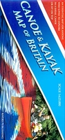
Great Britain Canoe And Kayak Map

Great Britain Canoe and Kayak Map from Rivers Publishing showing navigable rivers, lakes and canals, artificial white water courses, different classes of river difficulty, popular trips along the waterways, selected coastal paddles, specialist paddling retailers, etc.The base is provided by a double-sided road map of Britain at 1:625, 000. Different colouring indicates tidal rivers, waterways used by motorized craft and other flat water, as well as the four grades of difficulty. Particularly popular sections are prominently highlighted. The map also shows locations for selected loch and coastal trips, graded into intermediate and for experts only.White water centres are marked; locations of specialist paddling retailers are indicated by numbers cross-referenced to lists with full
contact details. There is also a panel with general advice on access and regulations. The map is surrounded by adverts for various retailers, specialist centres and agencies, etc.
RIP - This product is no longer available on our network. It was last seen on 25.09.2019

This page now acts as a permanent archive for this product. Add more information using the comments box below to ensure it can still be found by future generations.

Use our search facility to see if it is available from an alternative contributor.
  • Availability: Out Of Stock
  • Supplier: Stanfords
  • SKU: 9780955061431
Availability: In Stock
£9.95

Product Description

Great Britain Canoe & Kayak Map from Rivers Publishing showing navigable rivers, lakes & canals, artificial white water courses, different classes of river difficulty, popular trips along the waterways, selected coastal paddles, specialist paddling retailers, etc. The base is provided by a double-sided road map of Britain at 1:625, 000. Different colouring indicates tidal rivers, waterways used by motorized craft & other flat water, as well as the four grades of difficulty. Particularly popular sections are prominently highlighted. The map also shows locations for selected loch & coastal trips, graded into intermediate & for experts only. White water centres are marked; locations of specialist paddling retailers are indicated by numbers cross-referenced to lists with full contact details. There is also a panel with general advice on access & regulations. The map is surrounded by adverts for various retailers, specialist centres & agencies, etc.

Reviews/Comments

Add New

Intelligent Comparison

Oooops!
We couldn't find anything!
Perhaps this product's unique.... Or perhaps we are still looking for comparisons!
Click to bump this page and we'll hurry up.

Price History

Vouchers

No voucher codes found.
Do you know a voucher code for this product or supplier? Add it to Insights for others to use.

Facebook

Jargon Buster

White - A colour combining all colours
water - A chemical substance. Chemical formula H2O.
Road - a manmade lane or a path that is used to speed up travel.
Popular - Something that is admired and liked by many people.

Supplier Information

Stanfords
Stanfords was established in 1853 and opened their iconic Covent Garden flagship store in 1901. They have become the top retailer of maps, travel books and accessories in the UK and arguably offer the largest selection of maps and travel books worldwide. Famous names such as Captain Robert Falcon Scott, Ranulph Fiennes and Michael Palin have purchased from Stanfords. They now have a shop in Bristol and both stores together with other venues operate a calendar of events including talks, book signings and exhibitions. As a specialist map retailer, the map selection is comprehensive and includes road maps, street maps and walking maps from worldwide destinations, as well as a selection of world atlases and wall maps. Books include travel guides and travel literature. Stanfords also stock globes, from miniatures made of blue marble to magnificent floor-standing globes. The website features a selection of interesting articles on travel topics.
Page Updated: 2023-11-12 20:15:36

Community Generated Product Tags

Oh No! The productWIKI community hasn't generated any tags for this product yet!
Menu