More From Contributor
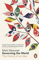
£17.99
Topographic survey of Portugal at 1:50, 000 from the Instituto Geográfico Português, the country’s civilian survey organisation. The maps have contours at 25m intervals & in addition to the standard features shown on topographic mapping at this scale also indicate various types of vegetation (vineyards, olive groves, etc). Each sheet covers an area of 32 x 20km (20 x 12.5miles approx). The maps have latitude & longitude margin ticks at 1’ intervals & UTM coordinates for the map corners – each sheet also shows conversion details from BBLx (Bessel-Bonnie system, Datum Lisbon) to UTM. Map legend is in Portuguese only.EDITION DATES: most titles in this series have now been updated in the 1990s or later. To see all the titles in this series please click on the series link. ...
Archived Product
£9.50
Topographical survey of Belgium at 1:20, 000 from Nationaal Geografisch Instituut / Institut Géographique National, the country’s national survey organization. Each 20K map covers one quarter of the corresponding 1:50, 000 map (with adjustments in the border & coastal areas). The maps provide all the information expected of topographic mapping at this scale & in addition have an unusually large amount of vegetation and/or land use information (different types of woodlands, gardens, orchards, heath, etc). The maps have a 1-km UTM grid, with margin ticks for latitude & longitude at intervals of 1`. Map legend & a glossary of terms used on the maps include English. Stanfords keeps as regular stock 20K maps for the World War I battlefields around the Ypres, Messines & Passchendaele, & for the area of the Battle of Waterloo. The 1:20, 000 survey covers the whole of Belgium & maps for other regions can be supplied as special orders. To see the list of titles in this series please click on the series link.PLEASE NOTE: the Long-Distance Footpaths Map of Belgium at 1:300, 000 which shows the division of Belgium into the 50K survey sheets can also be used to see in more detail coverage by the 20K maps. ...
Archived Product
£11.50
Topographic survey of France at 1:25, 000 in IGN`s excellent TOP25 / Série Bleue series. All the maps are GPS compatible, with a 1km UTM grid plus latitude & longitude lines at 5’ intervals. Contours are at 5m intervals except for mountainous areas where the maps have contours at 10m intervals, vividly enhanced by hill shading & graphics for rocky terrain. Colouring with graphics indicates different types of vegetation or land use (deciduous or coniferous forests, moors, orchards, vineyards, etc). PLEASE NOTE: coverage of France at this scale is currently being revised – the format & the presentation of each title are indicated by the letters at the end of its Sheet Reference number (e.g. 0416ET, 3531ETR, 1923SB, etc.)MAPS WITH FULL TOURIST OVERPRINT & AN ENGLISH MAP LEGEND: all TOP25 maps & the SB editions of Série Bleue have an overprint highlighting waymarked walking trails including long-distance GR routes &, where appropriate, ski routes. Symbols indicate campsites, gîtes d’etape, refuges, equestrian centres & other recreational facilities or sites, tourist information centres, cultural heritage, etc. Towns & locations of particular interest are highlighted.- ET or OT = single-sided TOP25 map covering approx. 29x 21 km / 18x 13 miles.- ETR or OTR = waterproof & tear resistant TOP25 map covering the same area as the corresponding ET or OT number, but double-sided, printed on a smaller size sheet with a good overlap between the sides.- SB = Série Bleue map with full tourist overprint; these maps, first introduced in summer 2014, each cover approx. 29x 24km / 18x 15 miles.SÉRIE BLEUE maps with numbers ending in E (Est) or O (Ouest): most editions now indicate the GR routes, but do not show any other tourist information. Map legend is in French only. Each map covers approx. 14x 20km / 9x 12 miles. ...
Archived Product
£3.50
Govan area of Glasgow in 1894 in a fascinating series of reproductions of old Ordnance Survey plans in the Alan Godfrey Editions, ideal for anyone interested in the history of their neighbourhood or family. Two versions have been published for this area. The maps cover the area from Elder Park eastward to Cessnock Dock, & from Fairfield Works southward to Ibrox Park. Features include part of the Clyde, with Canning Basin, Yorkhill Quays, Outer Basin (part), Govan Yard with graving docks, Govan Branch railway with Govan station, Princes Dock Joint Railway, town centre around Govan Cross, Drumoyne Siding, tramways, several other industrial & shipbuilding premises, etc. Selections from early directories are on the reverse. About the Alan Godfrey Editions of the 25” OS Series: Selected towns in Great Britain & Ireland are covered by maps showing the extent of urban development in the last decades of the 19th & early 20th century. The plans have been taken from the Ordnance Survey mapping & reprinted at about 15 inches to one mile (1:4, 340). On the reverse most maps have historical notes & many also include extracts from contemporary directories. Most maps cover about one mile (1.6kms) north/south, one & a half miles (2.4kms) across; adjoining sheets can be combined to provide wider coverage.FOR MORE INFORMATION & A COMPLETE LIST OF ALL AVAILABLE TITLES PLEASE CLICK ON THE SERIES LINK. ...
Archived Product
£3.50
Govan area of Glasgow in 1909 in a fascinating series of reproductions of old Ordnance Survey plans in the Alan Godfrey Editions, ideal for anyone interested in the history of their neighbourhood or family. Two versions have been published for this area. The maps cover the area from Elder Park eastward to Cessnock Dock, & from Fairfield Works southward to Ibrox Park. Features include part of the Clyde, with Canning Basin, Yorkhill Quays, Outer Basin (part), Govan Yard with graving docks, Govan Branch railway with Govan station, Princes Dock Joint Railway, town centre around Govan Cross, Drumoyne Siding, tramways, several other industrial & shipbuilding premises, etc. Selections from early directories are on the reverse. About the Alan Godfrey Editions of the 25” OS Series: Selected towns in Great Britain & Ireland are covered by maps showing the extent of urban development in the last decades of the 19th & early 20th century. The plans have been taken from the Ordnance Survey mapping & reprinted at about 15 inches to one mile (1:4, 340). On the reverse most maps have historical notes & many also include extracts from contemporary directories. Most maps cover about one mile (1.6kms) north/south, one & a half miles (2.4kms) across; adjoining sheets can be combined to provide wider coverage.FOR MORE INFORMATION & A COMPLETE LIST OF ALL AVAILABLE TITLES PLEASE CLICK ON THE SERIES LINK. ...
Archived Product
£6.39
A detailed topographic map of Gower from the Ordnance Survey Explorer series, covering Llanelli. Edition A3; Publication date September 2011 About this series: These highly detailed maps show all the administrative boundaries, settlements as small as isolated farms, the road network down to unfenced roads & country tracks, & field boundaries (hedges & drystone walls) which make navigation across the countryside much easier. Steep gradients on roads are indicated. Various landmarks, e.g. powerlines, archaeological sites, windmills, churches & lighthouses are shown & additional graphics indicate natural terrain features such as cliffs, scree, mud & vegetation variations. The contour interval is 5 metres in the lower parts of the country & 10 metres in the uplands, & spot heights are marked. Each map covers an area of 30 x 20km (i.e. approx. 19 x 12 miles), with some double-sided maps covering more, as indicated in the individual descriptions. The maps are fully GPS compatible, with the National Grid shown at 1km intervals & latitude & longitude indicated by margin ticks at 1'. The Explorer series has replaced the earlier, green-cover Pathfinder maps. The Explorer series is now complete & covers all of Engl&, Wales & Scotl&. Some sheets for popular areas like the National Parks are still branded as Outdoor Leisure (OL) maps, but are now included in this series as the cartography is the same as that in the Explorer Maps. The Explorer maps offer a substantial improvement on the Pathfinder series, with greater use of colour, larger area per map, & stronger emphasis on information for ramblers & tourists. This series is ideal for walking & other outdoor pursuits & each map shows a large amount of information for ramblers & tourists. Public rights of way are shown (except in Scotland), together with other routes with public access: National Trails & Recreational Paths, permitted paths & bridleways, & selected cycle routes. Open access land created under the Countryside & Rights of Way Act 2000 is marked. Tourist information

Includes::
caravan & campsites, Park & Ride locations, recreation/leisure/sport centres, museums, historic buildings, English Heritage & National Trust sites, rural pubs, etc. The map legend is in English only, except for the tourist information content which is also in French & German.

...
Archived Product
£14.99
Gower
- Llanelli area on a detailed topographic & GPS compatible map No. 164, waterproof version, from the Ordnance Survey’s
...
Archived Product
£8.99
Gower
- Llanelli area on a detailed topographic & GPS compatible map No. 164, paper version, from the Ordnance Survey’s 1:25,
...
Archived Product
£11.19
Laminated waterproof edition of a detailed topographic map from the Ordnance Survey Explorer series, covering Llanelli. Edition A3: Publication date December 2011 About this series: These highly detailed maps show all the administrative boundaries, settlements as small as isolated farms, the road network down to unfenced roads & country tracks, & field boundaries (hedges & drystone walls) which make navigation across the countryside much easier. Steep gradients on roads are indicated. Various landmarks, e.g. powerlines, archaeological sites, windmills, churches & lighthouses are shown & additional graphics indicate natural terrain features such as cliffs, scree, mud & vegetation variations. The contour interval is 5 metres in the lower parts of the country & 10 metres in the uplands, & spot heights are marked. Each map covers an area of 30 x 20km (i.e. approx. 19 x 12 miles), with some double-sided maps covering more, as indicated in the individual descriptions. The maps are fully GPS compatible, with the National Grid shown at 1km intervals & latitude & longitude indicated by margin ticks at 1'. The Explorer series has replaced the earlier, green-cover Pathfinder maps. The Explorer series is now complete & covers all of Engl&, Wales & Scotl&. Some sheets for popular areas like the National Parks are still branded as Outdoor Leisure (OL) maps, but are now included in this series as the cartography is the same as that in the Explorer Maps. The Explorer maps offer a substantial improvement on the Pathfinder series, with greater use of colour, larger area per map, & stronger emphasis on information for ramblers & tourists. This series is ideal for walking & other outdoor pursuits & each map shows a large amount of information for ramblers & tourists. Public rights of way are shown (except in Scotland), together with other routes with public access: National Trails & Recreational Paths, permitted paths & bridleways, & selected cycle routes. Open access land created under the Countryside & Rights of Way Act 2000 is marked. Tourist information

Includes::
caravan & campsites, Park & Ride locations, recreation/leisure/sport centres, museums, historic buildings, English Heritage & National Trust sites, rural pubs, etc. The map legend is in English only, except for the tourist information content which is also in French & German.

...
Archived Product
£14.99
This is a selective rock climbing guide to the Gower peninsula in South Wales. Gower Rock aims to showcase the depth & quality of rock climbing on this wild, beautiful yet somewhat unknown peninsula. The area contains a wide variety of climbing on an enticing array of venues. On some routes you can step straight off golden sands onto classic lines; in other cases you can send your way across peaceful cliff-top paths before dropping into some pretty demanding terrain just a stone`s throw from ice-cream-scoffing tourists & pastoral picnic spots. The magnificent areas of Fall Bay & Three Cliffs have enough classic routes to keep you busy on many visits to the peninsula. The sport crags of Southgate compliment & add variety to the well-established hard routes of Oxwich & Pwlldu. The selection of venues & climbs included in this guide will provide plenty of adventure for all climbers, among some of the best scenery in the UK. In 1956 the Gower peninsula was designated as the UK`s first Area of Natural Outstanding Beauty (AONB). Any visitor to the area will see why: it is packed full of stunning beaches & welcoming villages & provides a breath-taking backdrop to numerous outdoor activities including surfing & paragliding. There are miles of fantastic coastal paths to walk along (a perfect way to explore the many treats of the peninsula) & copious amounts of climbing. Stuart Llewellyn is a passionate climber, new router & local enthusiast. His dedication to the local climbing community through the BMC has not only enhanced access & support locally, but increased the area`s national presence with the creation of the Gower Climbing Festival, the first step to the creation of this very guide. With the release of this book, & a step back from local climbing politics, Stuart is set to once again climb the rock, not just talk & write about it... Matt Woodfield is a climbing instructor who works locally; teaching, instructing & taking people on adventures. Soon after moving to Swansea to study at the University in 2002 Matt turned his passion for climbing to a profession & has never looked back. He enjoys nothing more than getting out on rock with people & helping them develop their skills, confidence & experience. ...
Archived Product

Governing The World

The compelling and provocative history of world government, from acclaimed author Mark Mazower. In 1815 the shocked and exhausted victors of the decades of fighting that had engulfed Europe for a generation agreed to a new system for keeping the peace. Instead of independent states changing sides, doing deals and betraying one another, a new, collegial `Concert of Europe` would ensure that the brutal chaos of the Napoleonic Wars never happened again. Mark Mazower`s remarkable new book recreates two centuries of international government - the struggle to spread values and build institutions to bring order to an anarchic and dangerous state system.
RIP - This product is no longer available on our network. It was last seen on 25.09.2019

This page now acts as a permanent archive for this product. Add more information using the comments box below to ensure it can still be found by future generations.

Use our search facility to see if it is available from an alternative contributor.
  • Availability: Out Of Stock
  • Supplier: Stanfords
  • SKU: 9780141011936
Availability: In Stock
£12.99

Product Description

The compelling & provocative history of world government, from acclaimed author Mark Mazower. In 1815 the shocked & exhausted victors of the decades of fighting that had engulfed Europe for a generation agreed to a new system for keeping the peace. Instead of independent states changing sides, doing deals & betraying one another, a new, collegial ` Concert of Europe` would ensure that the brutal chaos of the Napoleonic Wars never happened again. Mark Mazower`s remarkable new book recreates two centuries of international government
- the struggle to spread values & build institutions to bring order to an anarchic & dangerous state system.

Reviews/Comments

Add New

Intelligent Comparison

Oooops!
We couldn't find anything!
Perhaps this product's unique.... Or perhaps we are still looking for comparisons!
Click to bump this page and we'll hurry up.

Price History

Vouchers

No voucher codes found.
Do you know a voucher code for this product or supplier? Add it to Insights for others to use.

Facebook

Jargon Buster

History - Anything that happens in the past. An acedemic subject.
World - A physical grouping, commonly used to describe earth and everything associated with ti

Supplier Information

Stanfords
Stanfords was established in 1853 and opened their iconic Covent Garden flagship store in 1901. They have become the top retailer of maps, travel books and accessories in the UK and arguably offer the largest selection of maps and travel books worldwide. Famous names such as Captain Robert Falcon Scott, Ranulph Fiennes and Michael Palin have purchased from Stanfords. They now have a shop in Bristol and both stores together with other venues operate a calendar of events including talks, book signings and exhibitions. As a specialist map retailer, the map selection is comprehensive and includes road maps, street maps and walking maps from worldwide destinations, as well as a selection of world atlases and wall maps. Books include travel guides and travel literature. Stanfords also stock globes, from miniatures made of blue marble to magnificent floor-standing globes. The website features a selection of interesting articles on travel topics.
Page Updated: 2023-11-12 20:15:36

Community Generated Product Tags

Oh No! The productWIKI community hasn't generated any tags for this product yet!
Menu