More From Contributor
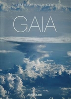
£16.99
Gabriel Garcia Marquez, author of the modern classic One Hundred Years of Solitude & Love in the Time of Cholera, is one of the greatest & most popular writers of the late-twentieth century. As Gerald Martin tells the story of the author`s fascinating rise to wealth & international fame, he reveals the tensions in Garcia Marquez`s life between celebrity & literary quality, between politics & writing, & between power, solitude & love. Interviewing more than three hundred people including Fidel Castro, Felipe Gonzalez, Carlos Fuentes & Mario Vargas Llosa, the author`s large family as well as ` Gabo` himself, Martin immerses himself in Garcia Marquez`s world. This at first `tolerated` & now `official` biography is as gripping & revealing as the writer`s journalism & as complex & involving as any of his fiction. ...
Archived Product
£13.99
This map of Gaddede Hotagsfjallen Follinge in 1:75, 000 is part of a series of topographic maps from Norstedts Kartforlaget which

Includes::
28 outdoor maps covering the mountain areas & popular recreation areas in southern Sweden. The maps in this series have a new look & are printed on a durable & water resistant paper. Cartography, material & printing quality provides clear & easy to read maps ideal for hiking, canoeing & mountain tours. Each map presents an accurate topography which describes local footpaths, cycle or ski routes, sport & recreational facilities, places of interest, places to stay & eat, viewpoints. The maps have contours at 5 metre intervals, plus relief shading & graphics for rocky outcrops & boulders. Further graphics and/or colouring show different types of land use or vegetation (forests, arable l&, orchards, marshes, peat bogs, etc). The maps have a 2-km UTM grid, plus latitude & longitude lines 10’ intervals. Map legend

Includes::
English. The mountain region is covered– from Riksgränsen in the north to Sälen in the south – in the unique scale of 1:75 000 & adapted to hiking trails. The Kungsleden trail is specially marked with information about distance & approximate hiking time for different stages. The maps for southern Sweden cover popular recreation areas on the east- & west coast in the scale – 1:50 000. To see the list of the other titles in this series, please click on the series link.


...
Archived Product
£8.99
` Gadfly in Russia is fascinating... Their journey
- by parts touching, hilarious, compulsive, hair-raising
- makes On the

...
Archived Product
£14.99
Discover the designs behind some of the most amazing inventions ever imagined. This book contains the original drawings submitted to the patent office for such indispensable items as the paperclip, the ball-point pen & the umbrella, as well as technological marvels like the space suit, the floppy disk & the Polaroid camera
- & not forgetting fun & frivolous things like the Barbie doll, the skateboard & the Game Boy. Expand your knowledge & inspire your inner inventor with this fully illustrated guide to the everyday gadgets, games & gizmos that changed the world!
...
Archived Product
£6.50
Topographic coverage of mainland Spain at 1:25, 000 published by the Centro Nacional de Información Geograficá, the country’s civilian survey organization. The maps have contours at 10m intervals & colouring and/or graphics to show different types of vegetation or land use. Boundaries of national parks & other protected areas are marked. In addition to all the usual information shown on topographic maps at this scale, detailed presentation of the road & rail networks, rural tracks & paths, etc, the maps also show campsites. The maps have a 1-km UTM grid, with margin ticks for latitude & longitude at 1` intervals. Map legend is in Spanish only.PLEASE NOTE: our grid for the whole of Spain is in preparation
- in the meantime, for areas other than those shown on the attached grid please use CNIG’s topographic survey at 1:50, 000 by searching for ‘SI00000832’. Each 25K map covers one quarter of the corresponding 50K map, with the numbering system: I = NW quarter, II = NE quarter, III = SW quarter & IV = SE quarter. CNIG maps in the Provincial Road Maps series at 1:200, 000 are overprinted with the grid for the 1:50, 000 survey & can be used to see the area covered by each 50K or 25K title in more detail. To see the list of titles in this series please click on the series grid
- for map numbers not yet listed on our website please contact us by email.

...
Archived Product
£12.99
Topographic survey of France at 1:25, 000 in IGN`s excellent TOP25 / Série Bleue series. All the maps are GPS compatible, with a 1km UTM grid plus latitude & longitude lines at 5’ intervals. Contours are at 5m intervals except for mountainous areas where the maps have contours at 10m intervals, vividly enhanced by hill shading & graphics for rocky terrain. Colouring with graphics indicates different types of vegetation or land use (deciduous or coniferous forests, moors, orchards, vineyards, etc). PLEASE NOTE: coverage of France at this scale is currently being revised – the format & the presentation of each title are indicated by the letters at the end of its Sheet Reference number (e.g. 0416ET, 3531ETR, 1923SB, etc.)MAPS WITH FULL TOURIST OVERPRINT & AN ENGLISH MAP LEGEND: all TOP25 maps & the SB editions of Série Bleue have an overprint highlighting waymarked walking trails including long-distance GR routes &, where appropriate, ski routes. Symbols indicate campsites, gîtes d’etape, refuges, equestrian centres & other recreational facilities or sites, tourist information centres, cultural heritage, etc. Towns & locations of particular interest are highlighted.- ET or OT = single-sided TOP25 map covering approx. 29x 21 km / 18x 13 miles.- ETR or OTR = waterproof & tear resistant TOP25 map covering the same area as the corresponding ET or OT number, but double-sided, printed on a smaller size sheet with a good overlap between the sides.- SB = Série Bleue map with full tourist overprint; these maps, first introduced in summer 2014, each cover approx. 29x 24km / 18x 15 miles.SÉRIE BLEUE maps with numbers ending in E (Est) or O (Ouest): most editions now indicate the GR routes, but do not show any other tourist information. Map legend is in French only. Each map covers approx. 14x 20km / 9x 12 miles. ...
Archived Product
£13.99
Gailtaler Alpen
- Karnische Alpen
- Oberdrautal (No. 60), a detailed, GPS compatible map at 1:50, 000 from Kompass with local

...
Archived Product
£10.50
Map No. 60, Gailtaler Alpen
- Karnische Alpen
- Oberdrautal, with a panorama map on the reverse, printed on strudy waterproof

...
Archived Product
£6.39
A detailed topographic map of Gairloch & Loch Ewe from the Ordnance Survey Explorer series. Edition A1; Publication date September 2007 About this series: These highly detailed maps show all the administrative boundaries, settlements as small as isolated farms, the road network down to unfenced roads & country tracks, & field boundaries (hedges & drystone walls) which make navigation across the countryside much easier. Steep gradients on roads are indicated. Various landmarks, e.g. powerlines, archaeological sites, windmills, churches & lighthouses are shown & additional graphics indicate natural terrain features such as cliffs, scree, mud & vegetation variations. The contour interval is 5 metres in the lower parts of the country & 10 metres in the uplands, & spot heights are marked. Each map covers an area of 30 x 20km (i.e. approx. 19 x 12 miles), with some double-sided maps covering more, as indicated in the individual descriptions. The maps are fully GPS compatible, with the National Grid shown at 1km intervals & latitude & longitude indicated by margin ticks at 1'. The Explorer series has replaced the earlier, green-cover Pathfinder maps. The Explorer series is now complete & covers all of Engl&, Wales & Scotl&. Some sheets for popular areas like the National Parks are still branded as Outdoor Leisure (OL) maps, but are now included in this series as the cartography is the same as that in the Explorer Maps. The Explorer maps offer a substantial improvement on the Pathfinder series, with greater use of colour, larger area per map, & stronger emphasis on information for ramblers & tourists. This series is ideal for walking & other outdoor pursuits & each map shows a large amount of information for ramblers & tourists. Public rights of way are shown (except in Scotland), together with other routes with public access: National Trails & Recreational Paths, permitted paths & bridleways, & selected cycle routes. Open access land created under the Countryside & Rights of Way Act 2000 is marked. Tourist information

Includes::
caravan & camp sites, Park & Ride locations, recreation/leisure/sport centres, museums, historic buildings, English Heritage & National Trust sites, rural pubs, etc. The map legend is in English only, except for the tourist information content which is also in French & German.

...
Archived Product
£11.19
Laminated waterproof edition of a detailed topographic map of Gairloch & Loch Ewe from the Ordnance Survey Explorer series Edition A1; Publication date September 2007 About this series: These highly detailed maps show all the administrative boundaries, settlements as small as isolated farms, the road network down to unfenced roads & country tracks, & field boundaries (hedges & drystone walls) which make navigation across the countryside much easier. Steep gradients on roads are indicated. Various landmarks, e.g. powerlines, archaeological sites, windmills, churches & lighthouses are shown & additional graphics indicate natural terrain features such as cliffs, scree, mud & vegetation variations. The contour interval is 5 metres in the lower parts of the country & 10 metres in the uplands, & spot heights are marked. Each map covers an area of 30 x 20km (i.e. approx. 19 x 12 miles), with some double-sided maps covering more, as indicated in the individual descriptions. The maps are fully GPS compatible, with the National Grid shown at 1km intervals & latitude & longitude indicated by margin ticks at 1'. The Explorer series has replaced the earlier, green-cover Pathfinder maps. The Explorer series is now complete & covers all of Engl&, Wales & Scotl&. Some sheets for popular areas like the National Parks are still branded as Outdoor Leisure (OL) maps, but are now included in this series as the cartography is the same as that in the Explorer Maps. The Explorer maps offer a substantial improvement on the Pathfinder series, with greater use of colour, larger area per map, & stronger emphasis on information for ramblers & tourists. This series is ideal for walking & other outdoor pursuits & each map shows a large amount of information for ramblers & tourists. Public rights of way are shown (except in Scotland), together with other routes with public access: National Trails & Recreational Paths, permitted paths & bridleways, & selected cycle routes. Open access land created under the Countryside & Rights of Way Act 2000 is marked. Tourist information

Includes::
caravan & camp sites, Park & Ride locations, recreation/leisure/sport centres, museums, historic buildings, English Heritage & National Trust sites, rural pubs, etc. The map legend is in English only, except for the tourist information content which is also in French & German.

...
Archived Product

Gaia

Cirque du Soleil founder and private space explorer Guy Laliberte unveils his unique photographs that capture the colors and textures only visible 220 miles away from the Earth s surface. This exclusive edition features a cloth spine and elegant topographic style embossing, all presented in a linen clamshell box. Proceeds for this book benefit Guy Laliberte`s ONE DROP foundation, which aims to eliminate poverty by providing access to clean water.”
RIP - This product is no longer available on our network. It was last seen on 25.09.2019

This page now acts as a permanent archive for this product. Add more information using the comments box below to ensure it can still be found by future generations.

Use our search facility to see if it is available from an alternative contributor.
  • External links may include paid for promotion
  • Availability: Out Of Stock
  • Supplier: Stanfords
  • SKU: 9782759405343
Availability: In Stock
£40.00

Product Description

Cirque du Soleil founder & private space explorer Guy Laliberte unveils his unique photographs that capture the colors & textures only visible 220 miles away from the Earth s surface. This exclusive edition features a cloth spine & elegant topographic style embossing, all presented in a linen clamshell box. Proceeds for this book benefit Guy Laliberte`s ONE DROP foundation, which aims to eliminate poverty by providing access to clean water.”

Reviews/Comments

Add New

Intelligent Comparison

Oooops!
We couldn't find anything!
Perhaps this product's unique.... Or perhaps we are still looking for comparisons!
Click to bump this page and we'll hurry up.

Price History

Vouchers

No voucher codes found.
Do you know a voucher code for this product or supplier? Add it to Insights for others to use.

Facebook

Jargon Buster

water - A chemical substance. Chemical formula H2O.
foundation - A flesh toned cosmetic applied to the face to create an even complexion.
Earth - A planet third from the sun. Similar size to Venus but rich in water and complex life.
Exclusive - Something that is not including other things.

Supplier Information

Stanfords
Stanfords was established in 1853 and opened their iconic Covent Garden flagship store in 1901. They have become the top retailer of maps, travel books and accessories in the UK and arguably offer the largest selection of maps and travel books worldwide. Famous names such as Captain Robert Falcon Scott, Ranulph Fiennes and Michael Palin have purchased from Stanfords. They now have a shop in Bristol and both stores together with other venues operate a calendar of events including talks, book signings and exhibitions. As a specialist map retailer, the map selection is comprehensive and includes road maps, street maps and walking maps from worldwide destinations, as well as a selection of world atlases and wall maps. Books include travel guides and travel literature. Stanfords also stock globes, from miniatures made of blue marble to magnificent floor-standing globes. The website features a selection of interesting articles on travel topics.
Page Updated: 2023-11-12 20:15:36

Community Generated Product Tags

Oh No! The productWIKI community hasn't generated any tags for this product yet!
Menu