More From Contributor

£12.99
Topographic survey of France at 1:25, 000 in IGN`s excellent TOP25 / Série Bleue series. All the maps are GPS compatible, with a 1km UTM grid plus latitude & longitude lines at 5’ intervals. Contours are at 5m intervals except for mountainous areas where the maps have contours at 10m intervals, vividly enhanced by hill shading & graphics for rocky terrain. Colouring with graphics indicates different types of vegetation or land use (deciduous or coniferous forests, moors, orchards, vineyards, etc). PLEASE NOTE: coverage of France at this scale is currently being revised – the format & the presentation of each title are indicated by the letters at the end of its Sheet Reference number (e.g. 0416ET, 3531ETR, 1923SB, etc.)MAPS WITH FULL TOURIST OVERPRINT & AN ENGLISH MAP LEGEND: all TOP25 maps & the SB editions of Série Bleue have an overprint highlighting waymarked walking trails including long-distance GR routes &, where appropriate, ski routes. Symbols indicate campsites, gîtes d’etape, refuges, equestrian centres & other recreational facilities or sites, tourist information centres, cultural heritage, etc. Towns & locations of particular interest are highlighted.- ET or OT = single-sided TOP25 map covering approx. 29x 21 km / 18x 13 miles.- ETR or OTR = waterproof & tear resistant TOP25 map covering the same area as the corresponding ET or OT number, but double-sided, printed on a smaller size sheet with a good overlap between the sides.- SB = Série Bleue map with full tourist overprint; these maps, first introduced in summer 2014, each cover approx. 29x 24km / 18x 15 miles.SÉRIE BLEUE maps with numbers ending in E (Est) or O (Ouest): most editions now indicate the GR routes, but do not show any other tourist information. Map legend is in French only. Each map covers approx. 14x 20km / 9x 12 miles. ...
Archived Product
£7.99
No.1 bestselling author Patricia Cornwell delivers the next enthralling thriller in her high-stakes series starring Kay Scarpetta-a complex tale involving a serial sniper who strikes chillingly close to the forensic sleuth herself. It`s Chief Medical Examiner Dr Kay Scarpetta`s birthday, & while she`s enjoying a leisurely morning, a man is shot dead five minutes from her house. The bullet tore through him as he unloaded groceries from his car. Yet nobody heard or saw a thing. It looks like the work of a serial sniper
- one who leaves no trace except for tiny copper fragments, & whose seemingly impossible shots cause instant death. As Scarpetta investigates, uncovering details that only she can analyze, she begins to suspect that the killer is sending her a message. Adding to Scarpetta`s growing unease is the sense that those closest to her are keeping secrets. & when her pursuit of the sniper takes Scarpetta to a shipwreck off the Florida coast, she comes face to face with shocking evidence that implicates her niece Lucy
- Scarpetta`s very own flesh & blood...

...
Archived Product
£8.99
Brazilian-born doctor André Cabral is living in London when one day he receives a letter from his home country, which he left nearly thirty years ago. A letter he keeps in his pocket for weeks, but tells no one about. The letter prompts André to remember the days of his youth
- torrid afternoons on Ipanema beach with his listless teenage friends, parties in elegant Rio apartments, his after-school job at his father`s plastic surgery practice
- &, above all, his secret infatuation with the daughter of his family`s maid, the intoxicating Luana. Unable to resist the pull of the letter, André embarks on a journey back to Brazil to rediscover his past.

...
Archived Product
£9.99
An intense journey into & out of rage & grief, via sex & violence, following 27 year-old artist, Sarah Browne & set mostly in the American Southwest. In New York, the ending of Sarah`s recent relationship with a married woman has coincided with the death of her estranged, aristocratic mother, leaving her a substantial amount of money & an unrecognised burden of toxic grief. Rather than return home to Engl&, she decides to travel by Greyhound to her mother`s cabin in New Mexico. There she`s drawn into a passionate relationship with Theo, a man whose quiet stability seems to complement her mercurial character. But as Sarah`s emotional turmoil grows, there are warning signs that tragedy could ensue. In Flesh of the Peach Scottish First Book of the Year winner, Helen Mc Clory, paints a beautiful & painful portrait of a woman`s unravelling, combining exquisite, & at times experimental, prose with a powerful understanding of the effects of unresolved loss. Mc Clory is one of the most exciting literary talents to emerge from Scotland in recent years. ...
Archived Product
£12.99
Topographic survey of France at 1:25, 000 in IGN`s excellent TOP25 / Série Bleue series. All the maps are GPS compatible, with a 1km UTM grid plus latitude & longitude lines at 5’ intervals. Contours are at 5m intervals except for mountainous areas where the maps have contours at 10m intervals, vividly enhanced by hill shading & graphics for rocky terrain. Colouring with graphics indicates different types of vegetation or land use (deciduous or coniferous forests, moors, orchards, vineyards, etc). PLEASE NOTE: coverage of France at this scale is currently being revised – the format & the presentation of each title are indicated by the letters at the end of its Sheet Reference number (e.g. 0416ET, 3531ETR, 1923SB, etc.)MAPS WITH FULL TOURIST OVERPRINT & AN ENGLISH MAP LEGEND: all TOP25 maps & the SB editions of Série Bleue have an overprint highlighting waymarked walking trails including long-distance GR routes &, where appropriate, ski routes. Symbols indicate campsites, gîtes d’etape, refuges, equestrian centres & other recreational facilities or sites, tourist information centres, cultural heritage, etc. Towns & locations of particular interest are highlighted.- ET or OT = single-sided TOP25 map covering approx. 29x 21 km / 18x 13 miles.- ETR or OTR = waterproof & tear resistant TOP25 map covering the same area as the corresponding ET or OT number, but double-sided, printed on a smaller size sheet with a good overlap between the sides.- SB = Série Bleue map with full tourist overprint; these maps, first introduced in summer 2014, each cover approx. 29x 24km / 18x 15 miles.SÉRIE BLEUE maps with numbers ending in E (Est) or O (Ouest): most editions now indicate the GR routes, but do not show any other tourist information. Map legend is in French only. Each map covers approx. 14x 20km / 9x 12 miles. ...
Archived Product
£10.99
This is the second of a series two recreational maps for the Flevoland region. These maps were created to celebrate the 25th anniversary of the province of Flevol&. They are double-sided indexed maps at 1:50, 000 scale, featuring a detailed topography with prominent highlighting of the cycle routes & packed with practical tourist information. They also include a calendar of annual events & feature all the local hiking trails. Falk maps give cycling distances between the junctions & indicate which roads, both within the numbered network & outside it, have separate cycling paths. Routes which are part of the LF network of long-distance cycle routes are clearly marked. A wide range of symbols shows various accommodation options, bars & restaurants, & various places of interest. Landscape information is provided by colouring for woodlands, dunes, etc. Map legend

Includes::
English. To see the list of other titles in this series please click on the series link.

...
Archived Product
£7.25
One of the titles in a series of recreational maps at scales suitable for walking & cycling, showing areas of cultural & conservation significance. There is some variation in the cartographic content, but a noticeable feature is the emphasis on land use & vegetation distribution, e.g. heath, sand dunes, woods, natural grassl&, salt marshes, etc. The maps show local footpaths, cycle & mountain bike paths, bridleways, waterways, campsites & other accommodation, various sport & recreation facilities, places of interest, etc. Road junctions show the numbers of the special signposts erected by the ANWB motoring organization. The maps have no geographical coordinates. Map legend

Includes::
English. On the reverse each title has supplementary information, in Dutch only, about the region's attractions. The maps are produced in conjunction with the Staatsbosbeheer, the organisation commissioned by the government to manage a considerable share of all the protected areas of the Netherlands.

...
Archived Product
£14.99
This Gooseneck Phone Holder is great for watching videos, taking photos, reading a recipe, as well as travelling & holding GPS. The super strong clamp attaches to anything smaller than 1.25” & fits digital devices less than 4” wide. Minimal assembly required.
Features:• Extends up to 31.5” (80cm), 360 angle & rotation. • Fits any device up to 3.9” wide (10cm).
...
Archived Product
£6.99
1944 Austria. A Nazi officer is tipped off that a Spanish Riding School groom is sheltering a Jewish boy at his stables. Jakob hides successfully but has to watch the officer threatenhis beloved Lipizzaner stallions just for spite. Jakob & his guardian know they must get the other horses away, but is it possible to get them all over the mountains to safety?A fleeing Roma girl, Kizzy, joins them, but the three of them face one gruelling trial after another as they try to cross the Austrian mountains, through Nazi territory. Can they do it, & what will be waiting on the other side? ...
Archived Product

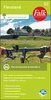
Fleurieu Peninsula, SA

The Fleurieu Peninsula south of Adelaide on an indexed road map at 1:150, 000 from Carto Graphics highlighting the course of the Heysen trekking trail, with on the reverse the Kangaroo Island plus enlargements showing in greater detail the McLaren Vale Wine region, the Deep Creek Conservation Park, and the Kuitpo Forest Reserve.On one side is a regional map at 1:150, 000 extending from Adelaide in the north-western corner eastwards to the Murray River and Lake Albert. The Kangaroo Island is on the reverse, shown at 1:300, 000. The map shows the region
RIP - This product is no longer available on our network. It was last seen on 25.09.2019

This page now acts as a permanent archive for this product. Add more information using the comments box below to ensure it can still be found by future generations.

Use our search facility to see if it is available from an alternative contributor.
  • External links may include paid for promotion
  • Availability: Out Of Stock
  • Supplier: Stanfords
  • SKU: 9780975683347
Availability: In Stock
£10.50

Product Description

The Fleurieu Peninsula south of Adelaide on an indexed road map at 1:150, 000 from Carto Graphics highlighting the course of the Heysen trekking trail, with on the reverse the Kangaroo Island plus enlargements showing in greater detail the McLaren Vale Wine region, the Deep Creek Conservation Park, & the Kuitpo Forest Reserve. On one side is a regional map at 1:150, 000 extending from Adelaide in the north-western corner eastwards to the Murray River & Lake Albert. The Kangaroo Island is on the reverse, shown at 1:300, 000. The map shows the region

Reviews/Comments

Add New

Intelligent Comparison

Oooops!
We couldn't find anything!
Perhaps this product's unique.... Or perhaps we are still looking for comparisons!
Click to bump this page and we'll hurry up.

Price History

Vouchers

No voucher codes found.
Do you know a voucher code for this product or supplier? Add it to Insights for others to use.

Facebook

Jargon Buster

Wine - An alcoholic drink made from fermented grapes.
Forest - A area with a high density of trees
Graphics - A general term for visual aspects of an item/display
Road - a manmade lane or a path that is used to speed up travel.
Regional - An adjective to describe a set geographic area.

Supplier Information

Stanfords
Stanfords was established in 1853 and opened their iconic Covent Garden flagship store in 1901. They have become the top retailer of maps, travel books and accessories in the UK and arguably offer the largest selection of maps and travel books worldwide. Famous names such as Captain Robert Falcon Scott, Ranulph Fiennes and Michael Palin have purchased from Stanfords. They now have a shop in Bristol and both stores together with other venues operate a calendar of events including talks, book signings and exhibitions. As a specialist map retailer, the map selection is comprehensive and includes road maps, street maps and walking maps from worldwide destinations, as well as a selection of world atlases and wall maps. Books include travel guides and travel literature. Stanfords also stock globes, from miniatures made of blue marble to magnificent floor-standing globes. The website features a selection of interesting articles on travel topics.
Page Updated: 2023-11-12 20:15:36

Community Generated Product Tags

Oh No! The productWIKI community hasn't generated any tags for this product yet!
Menu