More From Contributor

£30.99
Map No. Q-28 in the ONC series: military topographic survey mapping covering the world`s land masses & significant islands at 1:1, 000, 000. The maps are useful as general topographical coverage where nothing else is available, although they are designed primarily as flying charts for military aircraft. ONC stands for Operational Navigation Chart. Relief is portrayed by a combination of contours (basic interval 1000ft, intermediate contours shown where appropriate), elevation tinting & relief shading, plus spot heights. Towns, villages, major roads, railways & airports are shown but please note that many of the smaller settlements are not named & the road information is not necessarily up to date, as compilation & revision dates vary. Some air navigation information also appears on the map, such as radio beacons & restricted flying zones. Each ONC chart has both UTM & latitude/longitude grids overprinted on it, with additional margin ticks. *IMPORTANT
- PLEASE NOTE:** * The series is gradually being withdrawn from sale to the general public & some sheets may no longer be available when ordered by us.** Due to the nature of the map projection assembling these sheets to make a larger map is not recommended. in addition, colours used for relief are not constant throughout the series.* In some areas of central Africa & South America the maps have blank spaces, reflecting localized deficiencies or inconsistencies in the survey data.
...
Archived Product
£30.99
Map No. P-28 in the ONC series: military topographic survey mapping covering the world`s land masses & significant islands at 1:1, 000, 000. The maps are useful as general topographical coverage where nothing else is available, although they are designed primarily as flying charts for military aircraft. ONC stands for Operational Navigation Chart. Relief is portrayed by a combination of contours (basic interval 1000ft, intermediate contours shown where appropriate), elevation tinting & relief shading, plus spot heights. Towns, villages, major roads, railways & airports are shown but please note that many of the smaller settlements are not named & the road information is not necessarily up to date, as compilation & revision dates vary. Some air navigation information also appears on the map, such as radio beacons & restricted flying zones. Each ONC chart has both UTM & latitude/longitude grids overprinted on it, with additional margin ticks. *IMPORTANT
- PLEASE NOTE:** * The series is gradually being withdrawn from sale to the general public & some sheets may no longer be available when ordered by us.** Due to the nature of the map projection assembling these sheets to make a larger map is not recommended. in addition, colours used for relief are not constant throughout the series.* In some areas of central Africa & South America the maps have blank spaces, reflecting localized deficiencies or inconsistencies in the survey data.
...
Archived Product
£3.50
Chorley North in 1909 in a fascinating series of reproductions of old Ordnance Survey plans in the Alan Godfrey Editions, ideal for anyone interested in the history of their neighbourhood or family. The map covers the northern part of Chorley, stretching from Hollinshead Street northward to Hartwood Hall, & from Park Road eastward to Lower Healey Wood. Features include Talbot Mills, Lower Healey Bleach Works, Lancaster Canal, Heapey Bleach Works, Knowley Top, Botany Bay, Fosterfield Mill, Canal Mill, railway lines & engine shed, Diamond Mills, St Peter`s church, North Street Mills, Chorley Hall Farm, Hartwood Green, etc A commercial directory, entries A to H, is included on the reverse. About the Alan Godfrey Editions of the 25” OS Series: Selected towns in Great Britain & Ireland are covered by maps showing the extent of urban development in the last decades of the 19th & early 20th century. The plans have been taken from the Ordnance Survey mapping & reprinted at about 15 inches to one mile (1:4, 340). On the reverse most maps have historical notes & many also include extracts from contemporary directories. Most maps cover about one mile (1.6kms) north/south, one & a half miles (2.4kms) across; adjoining sheets can be combined to provide wider coverage.FOR MORE INFORMATION & A COMPLETE LIST OF ALL AVAILABLE TITLES PLEASE CLICK ON THE SERIES LINK. ...
Archived Product
£8.99
” The master of modern art” Whether you’re an accomplished artist, long-time student or a just massive fan of Pop Art, these funky socks make a great birthday gift & will get your creative chums talking. The master of modern art David Sock-Knee is on hand (or foot) when you want to impress with your knowledge of home-grown British artists. They are just the thing to wear to that exhibition opening event & don’t forget to snap a ‘sockie’ photo when you visit famous galleries. Follow in this famous face’s footsteps by recreating your favourite holiday scenes in acrylic – just don’t splash any on your art socks! ...
Archived Product
£8.99
” The ideal book club companion” Looking for a ‘novel’ gift for your literature-loving friend? We’ve got the ideal book club companion for them. Whether they love writing poetry or prose, Ernestoe Hemingway will give them the courage to put their soul (or sole…) into penning a masterpiece. Even though he says being broken makes you stronger, he won’t unravel at the seams under pressure. You can trust that he’ll be your loyal writing critic & show you there’s nothing to it – all you need is a typewriter & a bandage. With this funny sock character inside your shoes you’ll soon be on your way to winning the Man Footer Prize for literature. ...
Archived Product
£18.99
Southern Finland at 1:250, 000 on a double-sided cycling map from Karttakeskus with both national & local cycling routes, plus extensive tourist information including different types of accommodation. Enlargements show the routes in the Helsinki conurbations with a plan of central Helsinki, Tampere
- Nokia area with a plan of central Tampere, the Turku
- Raisio area with a plan of central Turku, plus across Forssa, Imatra, Heinola, Kouvola/ Kuusankoski, Kouvola/ Keskusta, Kotka, Leppeenranta, Lahti, Hyvinkää, Hameelinna, Kerava, Järvenpää, Pori, Provoo Borga, Salo, & Rauma. Maps in this Outdoor series from Karttakeskus cover southern Finland at 1:250, 000, with the northern part of the country at 1:400, 000. An overprint prominently highlights both national & local waymarked cycling routes, indicating unsurfaced sections, intermediate distances & routes which are part of the Euro Velo network. Enlargements present in more detail the main urban areas. The maps also indicate mountain bike routes, plus selected nature trails & canoeing routes. Railway lines are shown with stations & ferry connections are marked. An extensive range of symbols provide additional information: tourist information offices; different types of accommodation (campsites, holiday villages, youth hostels, huts, shelters, etc), sport & recreational facilities & sites including horse riding, canoeing, bird-watching, etc. Topography is shown by contours at 20m intervals with spot heights, plus colouring and/or graphics for marshl&, woodlands, etc. National parks & other protected areas are prominently marked. The maps also show which areas are currently covered by more detailed recreational maps published by Karttakeskus. The maps have both UTM & latitude/longitude grid lines. Each title also

Includes::
information of carrying cycles on public transport & notes on hiking, canoeing & snowmobile trails. Map legend & all the text include English. To see the other titles in this series please click on the series link.


...
Archived Product
£8.99
” Gifts for your arty friends” These state of the art socks feature Frida Callus who is best known for her sock-portraits recreated in cotton. If you’ve been searching for gifts for your arty friends, look no further – our funny art socks are the ideal gift for crafty folk & art students. Frida is the best sock friend to take to an art exhibition or when you need some help to start your own self-portrait! ...
Archived Product
£6.99
The Share Music Adaptor allows two head sets to be used on one portable music player, wherever you are, plane, train, bus or beach. Coming in a stylish design, this contemporary audio signal splitter fits most MP3s, DVDs, CDs, radios & laptops. So share your travel partner’s mp 3 or other music player! ~ Composition = plastic / electrical~ ...
Archived Product
£5.99
Southern Italy at 1:400, 000 in a series of indexed touring maps from Michelin. Insets show road access to central Naples & a street plan of the city, indicating principal sights & facilities, main traffic routes, one way street, & the restricted entry zone; each has a short index listing main streets. The map also indicates locations with street plans in the publishers’ Red Guide to hotels & restaurants in Italy &

Includes::
a distance table. Coverage

Includes::
the north-eastern part of Sicily, extending west to the outskirts of Palermo & south to Siracusa. The index in this title is next to the map. Maps in the Michelin’s touring series of Italy show the topography by relief shading with spot heights & colouring for woodlands. Road network emphasizes motorways & dual carriageway routes, presented with service areas & interchange numbers. Information on other roads

Includes::
less congested regional roads, scenic routes, gradients, seasonal restrictions & roads not recommended for caravans, etc. More detailed presentation of the road network is provided on Michelin’s Regional Series of Italy at 1:200, 000. The maps also show railway lines & ferry routes, both indicating facilities for transporting cars, plus local airports. Small symbols show various places of interest. Latitude & longitude lines are drawn at 20’ intervals. The index is on the reverse of the maps. Multilingual map legend

Includes::
English.


...
Archived Product
£14.99
Lonely Planet Seattle is your passport to all the most relevant & up-to-date advice on what to see, what to skip, & what hidden discoveries await you. Catch a flying fish at Pike Place Market, get dizzy atop the Space Needle, & indulge in Belltown`s progressive dining scene; all with your trusted travel companion. Get to the heart of Seattle & begin your journey now! Inside Lonely Planet`s Seattle Travel Guide: Color maps & images throughout. Highlights & itineraries show you the simplest way to tailor your trip to your own personal needs & interests. Insider tips save you time & money, & help you get around like a local, avoiding crowds & trouble spots. Essential info at your fingertips
- including hours of operation, phone numbers, websites, transit tips, & prices. Honest reviews for all budgets
- including eating, sleeping, sight-seeing, going out, shopping, & hidden gems that most guidebooks miss. Cultural insights give you a richer & more rewarding travel experience
- including history, music, cuisine, lifestyle, nightlife, & more. Free, convenient pull-out Seattle map (included in print version), plus over 30 color maps. Useful features
- including Walking Tours, With Kids, Day Trips, Month by Month (annual festival calendar), & more. Coverage of downtown, Pike Place Market, Pioneer Square, Belltown, Seattle Center, Queen Anne, Lake Union, Capitol Hill, the U District, Green Lake, Fremont, Ballard, Discovery Park, & more. The Perfect Choice: Lonely Planet Seattle, is a comprehensive guide to Seattle, is perfect for those planning to both explore the top sights & take the road less traveled. Looking for more extensive coverage? Check out Lonely Planet`s Washington, Oregon & the Pacific Northwest guide for a comprehensive look at all the region has to offer. Authors: Written & researched by Lonely Planet, Brendan Sainsbury, & Celeste Brash. About. Lonely Planet: Started in 1973, Lonely Planet has become the world`s leading travel guide publisher with guidebooks to every destination on the planet, as well as an award-winning website, a suite of mobile & digital travel products, & a dedicated traveler community. Lonely Planet`s mission is to enable curious travelers to experience the world & to truly get to the heart of the places they find themselves in.”” Trip Advisor Travelers` Choice Awards 2012 & 2013 winner in Favorite Travel Guide category””` Lonely Planet guides are, quite simply, like no other.` -” The New York Times””` Lonely Planet.


...
Archived Product

Feetasso Large

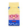
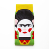
”Still Life with a Pair of Socks”For those days when you’ve got creative block and sit staring at a blank piece of paper for hours, Feetasso funny art socks will get your creative juices flowing. With artwork hanging in the Toete Modern, Feetasso will teach you everything you need to know about the Toebism art movement while discussing masterpieces such as `Still Life with a Pair of Socks`. This artistic character wants to inspire you to ‘brush up’ on your painting skills and will collaborate with you on your next big exhibition. Feetasso cool art socks are a great gift for any budding artist.
RIP - This product is no longer available on our network. It was last seen on 25.09.2019

This page now acts as a permanent archive for this product. Add more information using the comments box below to ensure it can still be found by future generations.

Use our search facility to see if it is available from an alternative contributor.
  • External links may include paid for promotion
  • Availability: Out Of Stock
  • Supplier: Stanfords
  • SKU: 0019372922339
Availability: In Stock
£8.99

Product Description

” Still Life with a Pair of Socks” For those days when you’ve got creative block & sit staring at a blank piece of paper for hours, Feetasso funny art socks will get your creative juices flowing. With artwork hanging in the Toete Modern, Feetasso will teach you everything you need to know about the Toebism art movement while discussing masterpieces such as ` Still Life with a Pair of Socks`. This artistic character wants to inspire you to ‘brush up’ on your painting skills & will collaborate with you on your next big exhibition. Feetasso cool art socks are a great gift for any budding artist.

Reviews/Comments

Add New

Intelligent Comparison

Oooops!
We couldn't find anything!
Perhaps this product's unique.... Or perhaps we are still looking for comparisons!
Click to bump this page and we'll hurry up.

Price History

Vouchers

No voucher codes found.
Do you know a voucher code for this product or supplier? Add it to Insights for others to use.

Facebook

Jargon Buster

Paper - A thin sheet mainly used for writing. Available in a variety of colours. Made mainly from wood pulp.
Socks - A garment worn on the feet
Gift - Something that is presented without expecting anything in return
Large - something that takes up more space than normal.
Brush - A tool with a handle and bristles set into a block to preen.

Supplier Information

Stanfords
Stanfords was established in 1853 and opened their iconic Covent Garden flagship store in 1901. They have become the top retailer of maps, travel books and accessories in the UK and arguably offer the largest selection of maps and travel books worldwide. Famous names such as Captain Robert Falcon Scott, Ranulph Fiennes and Michael Palin have purchased from Stanfords. They now have a shop in Bristol and both stores together with other venues operate a calendar of events including talks, book signings and exhibitions. As a specialist map retailer, the map selection is comprehensive and includes road maps, street maps and walking maps from worldwide destinations, as well as a selection of world atlases and wall maps. Books include travel guides and travel literature. Stanfords also stock globes, from miniatures made of blue marble to magnificent floor-standing globes. The website features a selection of interesting articles on travel topics.
Page Updated: 2023-11-12 20:15:36

Community Generated Product Tags

Oh No! The productWIKI community hasn't generated any tags for this product yet!
Menu