More From Contributor

£7.99
THE NEW YORK TIMES TOP TEN BESTSELLER WINNER OF THE 2014 KIRKUS PRIZE FOR FICTION Inspired by the true story of a woman who changed the way we understand our world. In 1933 three young, gifted anthropologists are thrown together in the jungle of New Guinea. They are Nell Stone, fascinating, magnetic & famous for her controversial work studying South Pacific tribes, her intelligent & aggressive husband Fen, & Andrew Bankson, who stumbles into the lives of this strange couple & becomes totally enthralled. Within months the trio are producing their best ever work, but soon a firestorm of fierce love & jealousy begins to burn out of control, threatening their bonds, their careers, &, ultimately, their lives.. .` Dazzling` Emma Donoghue, author of Room ...
Archived Product
£5.99
Eure & Seine-Maritime départments at 1:150, 000 in Michelin’s Local Series of France, with highlighting for scenic routes, an index, a special panel with best sights & recommended driving tours, & street plans of central Rouen & Evreux. Coverage extends from Abbeville & Le Trèpot to the outskirts of Paris & Chartres in the south-eastern corner of the map, &

Includes::
Dieppe, Fécamp, Le Havre, Hornfleur, etc. PLEASE NOTE: our coverage image, provided by the publishers, does not take into account which areas along the edge of the map are blocked by the index & the additional features. Maps in Michelin’s Local Series of France have the same cartography (road network & place names shown on the maps) as the publishers’ Regional Series at 1;200, 000 but enlarged here to 1:150, 000 to provide greater clarity & larger, easier to read print size. Road network is presented in great detail, indicating width, motorway services & rest areas, dangerous or restricted entry roads, steep gradients, height & weight restrictions, etc. Scenic sections are highlighted. The maps also show selected cycle paths & nature trails. Railway lines are shown with stations & local airports are marked. Symbols indicate various places of interest, with additional star rating for best sights, based on the publishers’ Green Guides for French regions. Satellite-derived base with colouring for the forested areas & boundaries of national or regional parks shows the topography. In the mountainous regions the maps have bold, very effective relief shading, with a large number of names of peaks, passes, & other topographic features. The maps have latitude & longitude lines at 10’ intervals & are indexed. Map legend

Includes::
English. Each title in addition

Includes::
a panel showing the area’s principal roads & places of interest, plus recommendations for sightseeing tours. Also provided are town centre maps of main cities, indicating principal traffic arteries, one way streets & places of interest. Only selected streets are named & listed in the accompanying index. Please click on the series link to see all the titles in this series.


...
Archived Product
£5.99
Paris with the départments of Eure-et-Loir & Yvelines at 1:150, 000 in Michelin’s Local Series of France, with highlighting for scenic routes, an index, a special panel with best sights & recommended driving tours, & street plans of central Chartres & Versailles. North of Paris the map extends to Chantilly & Senlis, east to Fontainebleau, & south to Orléans. PLEASE NOTE: our coverage image, provided by the publishers, does not take into account which areas along the edge of the map are blocked by the index & the additional features – in the south-west the map does not extend beyond Pithiviers. Maps in Michelin’s Local Series of France have the same cartography (road network & place names shown on the maps) as the publishers’ Regional Series at 1;200, 000 but enlarged here to 1:150, 000 to provide greater clarity & larger, easier to read print size. Road network is presented in great detail, indicating width, motorway services & rest areas, dangerous or restricted entry roads, steep gradients, height & weight restrictions, etc. Scenic sections are highlighted. The maps also show selected cycle paths & nature trails. Railway lines are shown with stations & local airports are marked. Symbols indicate various places of interest, with additional star rating for best sights, based on the publishers’ Green Guides for French regions. Satellite-derived base with colouring for the forested areas & boundaries of national or regional parks shows the topography. In the mountainous regions the maps have bold, very effective relief shading, with a large number of names of peaks, passes, & other topographic features. The maps have latitude & longitude lines at 10’ intervals & are indexed. Map legend

Includes::
English. Each title in addition

Includes::
a panel showing the area’s principal roads & places of interest, plus recommendations for sightseeing tours. Also provided are town centre maps of main cities, indicating principal traffic arteries, one way streets & places of interest. Only selected streets are named & listed in the accompanying index. Please click on the series link to see all the titles in this series.


...
Archived Product
£19.99
” The ancient Greeks continue to fascinate us
- they gave us our alphabet & much of our scientific, medical & cultural language;
...
Archived Product
£8.99
Medicine, anatomy, astronomy, mathematics & cosmology, science began with the Greeks, & Plato, Aristotle, Pythagoras, Archimedes & Hippocrates were amongst its stars. That man ever managed to develop a `scientific` attitude to the natural world at all is one of the true wonders of human thought. Eureka! shows how, free from intellectual & religious dogma, these early thinkers rejected myths & capricious gods &, in distinguishing between the natural & supernatural, effectively discovered nature. Andrew Gregory, Professor of History & Philosophy of Science at University College London, unravels the genesis of science in this fascinating exploration of the origins of Western civilisation, & our desire for a rational, legitimating system of the world. ...
Archived Product
£13.95
German language guide to the central section of the E1 trans-Europe long-distance footpath, covering the route from the Danish/ German border to Lake Constance & then across Switzerland to Lugano. The 1773-km long German section of the route crosses the western part of country, from Flensburg to Hamburg & across to Teutoburger Wald, Eggegebirge, Sauerl&, Westerwald, Taunus, Odenwald & Black Forest to Constance (Konstanz). The 320-km Swiss section leads from Lake Constance to the Gotthard Pass & on to Lugano. The route is highlighted on mapping at 1:200, 000 but for each segment the guide

Includes::
recommendations for more detailed hiking maps (NB. Not all possibilities are listed, so please browse through our website to select the most suitable maps). Each daily segment is presented with a description, details of waymarking, altitude of peaks & passes, etc. The guide also

Includes::
brief notes & general overview maps of the route in Sweden & Denmark before it enters Germany, & of its continuation from Lugano across Italy: from Como towards Genoa where it joins the Alta Via del Monti Liguri & then GEA
- Grande Escursione Appenninica.ALL THE TEXT IS IN GERMAN ONLY.


...
Archived Product
£13.95
German language guide to the central section of the E5 trans-Europe long-distance footpath, covering the route from Lake Constance across the German & Austrian Alps to the Dolomites & Lake Garda or Verona in Italy. The route follows the southern shore of Lake Constance to Bregenz, continues across the Alg ...
Archived Product
£4.99
A double sided map of Europe to the scale of 1:6, 100, 000. One side of the map is Europe-Political, the other Europe-Physical. Both sides of the map give lines of latitude & longitude & also include the margins of Africa & Asia which border on the continent. The Europe-Political map displays national flags & details basic information about each country ...
Archived Product
£5.99
Europe on a very large double-sided, indexed map from Insight Guides covering most of the continent at 1:2, 500, 000, with western Russia, eastern Ukraine & Turkey shown at 1:4, 500, 000. The map provides an overview of the road network: main railway lines & ferry routes are also included. Locations of interest are prominently highlighted. A very wide range of symbols indicate sights of natural or geographical interest including national parks, historical or archaeological remains, remarkable buildings, etc. The map has latitude & longitude lines at intervals of 1 ...
Archived Product
£5.99
Introducing a brand new series of road maps from Berlitz. This series provides comprehensive coverage of Europe, including clear, detailed road mapping with relief shading, distance indicators to aid route planning & street plans for major towns & cities. Scenic routes & places of interest have been highlighted for easy reference, & a comprehensive index booklet of place names has also been included. ...
Archived Product

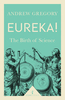
Eureka!: The Most Amazing Scientific Discoveries Of All Time

This exciting, educational children`s book details the real-life stories of scientists throughout history who made discoveries that changed the way we think about the world. Read about Galileo and Marie Curie, who both - in very different circumstances - risked peril during their research, or about Alexander Fleming, who discovered the power of penicillin by accident. Packed with fascinating details of experiments and equipment, blunders and lucky escapes, Eureka! will appeal to children around the age of 9 and over with an interest in history, science and adventure.
RIP - This product is no longer available on our network. It was last seen on 25.09.2019

This page now acts as a permanent archive for this product. Add more information using the comments box below to ensure it can still be found by future generations.

Use our search facility to see if it is available from an alternative contributor.
  • Availability: Out Of Stock
  • Supplier: Stanfords
  • SKU: 9780500292273
Availability: In Stock
£8.95

Product Description

This exciting, educational children`s book details the real-life stories of scientists throughout history who made discoveries that changed the way we think about the world. Read about Galileo & Marie Curie, who both
- in very different circumstances
- risked peril during their research, or about Alexander Fleming, who discovered the power of penicillin by accident. Packed with fascinating details of experiments & equipment, blunders & lucky escapes, Eureka! will appeal to children around the age of 9 & over with an interest in history, science & adventure.

Reviews/Comments

Add New

Intelligent Comparison

Oooops!
We couldn't find anything!
Perhaps this product's unique.... Or perhaps we are still looking for comparisons!
Click to bump this page and we'll hurry up.

Price History

Vouchers

No voucher codes found.
Do you know a voucher code for this product or supplier? Add it to Insights for others to use.

Facebook

Jargon Buster

History - Anything that happens in the past. An acedemic subject.
World - A physical grouping, commonly used to describe earth and everything associated with ti
Adventure - an undertaking of an exciting challenge or experience.
Equipment - A product or good that is tactile.
Children - A young life form within the early stages of physical development,

Supplier Information

Stanfords
Stanfords was established in 1853 and opened their iconic Covent Garden flagship store in 1901. They have become the top retailer of maps, travel books and accessories in the UK and arguably offer the largest selection of maps and travel books worldwide. Famous names such as Captain Robert Falcon Scott, Ranulph Fiennes and Michael Palin have purchased from Stanfords. They now have a shop in Bristol and both stores together with other venues operate a calendar of events including talks, book signings and exhibitions. As a specialist map retailer, the map selection is comprehensive and includes road maps, street maps and walking maps from worldwide destinations, as well as a selection of world atlases and wall maps. Books include travel guides and travel literature. Stanfords also stock globes, from miniatures made of blue marble to magnificent floor-standing globes. The website features a selection of interesting articles on travel topics.
Page Updated: 2023-11-12 20:15:36

Community Generated Product Tags

Oh No! The productWIKI community hasn't generated any tags for this product yet!
Menu