More From Contributor
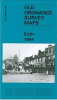
£14.99
This is a delightful collection of 100 postcards, featuring the beautiful & iconic artwork of Eric Carle, creator of The Very Hungry Caterpillar. Showcasing brand new artwork, alongside classic images, this exquisite box is a celebration of Carle`s extraordinary children`s book illustration talent. Send the gorgeous postcards to family & friends, or cherish the collection yourself. ...
Archived Product
£10.00
Originally produced in 1933 by the Kynoch Press, this perpetual week-to-week diary features beautiful wood block engravings by Eric Ravilious on every spread. The delightful illustrations follow the changing seasons, from roaring fires & snowy vignettes for the winter months to strawberries in the summer, bringing to life the simplicity of the English countryside. Beautifully designed, this is the perfect gift for gardeners & nature lovers as well as fans of Ravilious` work. ...
Archived Product
£8.99
When Erica Perkins wakes up on the morning of her tenth birthday, the last thing she expects is to find a very confused elephant sitting on her doorstep. So begins an unlikely friendship. But can a small girl & a rather large elephant learn to live together in a tiny terraced house? & when the dastardly owner of the local zoo plots to steal the elephant, will Erica be able to outsmart him? ...
Archived Product
£5.99
When Erica Perkins wakes up on the morning of her tenth birthday, the last thing she expects is to find a very confused elephant sitting on her doorstep. So begins an unlikely friendship. But can a small girl & a rather large elephant learn to live together in a tiny terraced house? & when the dastardly owner of the local zoo plots to steal the elephant, will Erica be able to outsmart him? ...
Archived Product
£6.99
Everybody knows that wolves live in packs. But one little wolf cub dreams of setting off on his own adventure... all by himself! Will life as a lone wolf be everything he hoped, or will he miss the rough & tumble of the pack? This fun adventure story featuring a cute wolf cub teaches young readers about the value of friendship, showing how good friends can still be with you, even when they`re not! ...
Archived Product
£21.95
Physical road map with inset thematic maps, climate table & brief historical notes. General relief is clearly depicted by a combination of hill-shading, altitude tinting, selected spot heights & contours at 200m intervals. Seasonally inundated areas are marked & off-shore coral reefs are included. Road classification distinguishes asphalt, gravel, dry-weather roads & tracks. Main railways are marked & symbols denote airports & ports. Additional symbols show historic & archaeological sites, lighthouses, monasteries & hot springs. Beyond the border of Eritrea no detail is shown. Latitude & longitude lines are drawn at 1 ...
Archived Product
£14.95
Map No. K-5A in the TPC series: military topographic survey mapping covering the world's land masses & significant islands at 1:500, 000. The maps are useful as general topographical coverage where nothing else is available, although they are designed primarily as flying charts for military aircraft. TPC stands for Tactical Pilotage Chart. Relief is portrayed by a combination of contours (basic interval 500ft, intermediate contours shown where appropriate), elevation tinting & relief shading, plus spot heights. Towns, villages, major roads, railways & airports are shown but please note that many of the smaller settlements are not named & the road information is not necessarily up to date, as compilation & revision dates vary. Some air navigation information also appears on the map, such as radio beacons & restricted flying zones. Each TPC chart has both UTM & latitude/longitude grids overprinted on it, with additional margin ticks. IMPORTANT
- PLEASE NOTE: The series is gradually being withdrawn from sale to the general public & some sheets may no longer be available when ordered by us. Due to the nature of the map projection assembling these sheets to make a larger map is not recommended. in addition, colours used for relief are not constant throughout the series. In some areas of central Africa & South America the maps have blank spaces, reflecting localized deficiencies or inconsistencies in the survey data.
...
Archived Product
£14.95
Map No. J-6D in the TPC series: military topographic survey mapping covering the world's land masses & significant islands at 1:500, 000. The maps are useful as general topographical coverage where nothing else is available, although they are designed primarily as flying charts for military aircraft. TPC stands for Tactical Pilotage Chart. Relief is portrayed by a combination of contours (basic interval 500ft, intermediate contours shown where appropriate), elevation tinting & relief shading, plus spot heights. Towns, villages, major roads, railways & airports are shown but please note that many of the smaller settlements are not named & the road information is not necessarily up to date, as compilation & revision dates vary. Some air navigation information also appears on the map, such as radio beacons & restricted flying zones. Each TPC chart has both UTM & latitude/longitude grids overprinted on it, with additional margin ticks. IMPORTANT
- PLEASE NOTE: The series is gradually being withdrawn from sale to the general public & some sheets may no longer be available when ordered by us. Due to the nature of the map projection assembling these sheets to make a larger map is not recommended. in addition, colours used for relief are not constant throughout the series. In some areas of central Africa & South America the maps have blank spaces, reflecting localized deficiencies or inconsistencies in the survey data.
...
Archived Product
£11.50
Erlangen in a series of GPS compatible recreational editions of the Bavarian topographic survey at 1:25, 000, with waymarked hiking trails & cycling routes, campsites & youth hostels, etc. Coverage

Includes::
Baiersdorf, Forchheim, Hemhofen, Neunkirchen a. Br&, Röttenbach, Kalchreuth. Contours used in this map vary between 5 to 20m according to the terrain, with 20m interval predominantly used for hilly areas. Varied colouring show different types of landscape: woods, vineyards, fields etc. Maps in this series feature extensive overprint highlighting local & long-distance footpaths & cycle routes, including King Ludwig Way or different variants of the Way of St James, indicating their waymarking. Symbols highlight different types of accommodation (campsites, youth hostels, refuges, etc), sport & recreational facilities, various places of interest, etc. The maps have a 1-km UTM grid. Map legend & all the text are in German only. To see other titles in this series please click on the series link.

...
Archived Product
£4.95
ADAC, Germany's equivalent of the British Automobile Association publishes an extensive series of street plans which provide detailed high-quality mapping of all the major towns & cities, including their outer suburbs. The plans name all the individual streets & indicate all the main landmarks & public buildings. All public transport facilities are shown: buses, trams, underground & overland rail lines. One way streets & car parks are indicated. Plans of larger cities include an enlargement for the city centre. The plans also show the administrative & postal divisions & have an extensive street index which, where appropriate, shows individual postal codes for each street. On the reverse, each plan has a road map at 1:100, 000, covering a very wide area around the city. Map legend

Includes::
English.

...
Archived Product

Erith 1864

Erith in 1864 in a fascinating series of reproductions of old Ordnance Survey plans in the Alan Godfrey Editions, ideal for anyone interested in the history of their neighbourhood or family. The map covers the Thames-side village of Erith. St John`s church is near the top and coverage continues south and east down West Street and High Street to include the busy village centre. Beyond this are Erith Gardens, with Erith Pier and the Pier Hotel; in 1842 the Guardians of the Wheatley Estate, which owned most of Erith, had tried to develop the village as a resort. The Wheatley Estate would be sold off in 1874, however, so this map captures Erith at an interesting earlier stage. Other features include Cray Coal Wharf, Randell Street, The Wheatley Arms, station, The Villas, Anchor Bay,
Upper Ballast Wharf with tramway. A very small portion of Essex is included across the river, showing Coldharbour Point.About the Alan Godfrey Editions of the 25” OS Series:Selected towns in Great Britain and Ireland are covered by maps showing the extent of urban development in the last decades of the 19th and early 20th century. The plans have been taken from the Ordnance Survey mapping and reprinted at about 15 inches to one mile (1:4, 340). On the reverse most maps have historical notes and many also include extracts from contemporary directories. Most maps cover about one mile (1.6kms) north/south, one and a half miles (2.4kms) across; adjoining sheets can be combined to provide wider coverage.FOR MORE INFORMATION AND A COMPLETE LIST OF ALL AVAILABLE TITLES PLEASE CLICK ON THE
SERIES LINK.
RIP - This product is no longer available on our network. It was last seen on 25.09.2019

This page now acts as a permanent archive for this product. Add more information using the comments box below to ensure it can still be found by future generations.

Use our search facility to see if it is available from an alternative contributor.
  • External links may include paid for promotion
  • Availability: Out Of Stock
  • Supplier: Stanfords
  • SKU: 9780850549812
Availability: In Stock
£3.50

Product Description

Erith in 1864 in a fascinating series of reproductions of old Ordnance Survey plans in the Alan Godfrey Editions, ideal for anyone interested in the history of their neighbourhood or family. The map covers the Thames-side village of Erith. St John`s church is near the top & coverage continues south & east down West Street & High Street to include the busy village centre. Beyond this are Erith Gardens, with Erith Pier & the Pier Hotel; in 1842 the Guardians of the Wheatley Estate, which owned most of Erith, had tried to develop the village as a resort. The Wheatley Estate would be sold off in 1874, however, so this map captures Erith at an interesting earlier stage. Other features include Cray Coal Wharf, Randell Street, The Wheatley Arms, station, The Villas, Anchor Bay, Upper Ballast Wharf with tramway. A very small portion of Essex is included across the river, showing Coldharbour Point. About the Alan Godfrey Editions of the 25” OS Series: Selected towns in Great Britain & Ireland are covered by maps showing the extent of urban development in the last decades of the 19th & early 20th century. The plans have been taken from the Ordnance Survey mapping & reprinted at about 15 inches to one mile (1:4, 340). On the reverse most maps have historical notes & many also include extracts from contemporary directories. Most maps cover about one mile (1.6kms) north/south, one & a half miles (2.4kms) across; adjoining sheets can be combined to provide wider coverage.FOR MORE INFORMATION & A COMPLETE LIST OF ALL AVAILABLE TITLES PLEASE CLICK ON THE SERIES LINK.

Reviews/Comments

Add New

Intelligent Comparison

Oooops!
We couldn't find anything!
Perhaps this product's unique.... Or perhaps we are still looking for comparisons!
Click to bump this page and we'll hurry up.

Price History

Vouchers

No voucher codes found.
Do you know a voucher code for this product or supplier? Add it to Insights for others to use.

Facebook

Jargon Buster

Contemporary - Modern era design
Contemporary - A design reference to indicate post war modern design
Hotel - An establishment which provides lodging for a fee
History - Anything that happens in the past. An acedemic subject.
Small - something that takes up less space than normal.
Contemporary - An object that is living in the same time.
Estate - A group of houses on the same land or area.
Ideal - Something that satisfies a perfect criteria.
Family - A group of people that live together made up from parents and children.

Supplier Information

Stanfords
Stanfords was established in 1853 and opened their iconic Covent Garden flagship store in 1901. They have become the top retailer of maps, travel books and accessories in the UK and arguably offer the largest selection of maps and travel books worldwide. Famous names such as Captain Robert Falcon Scott, Ranulph Fiennes and Michael Palin have purchased from Stanfords. They now have a shop in Bristol and both stores together with other venues operate a calendar of events including talks, book signings and exhibitions. As a specialist map retailer, the map selection is comprehensive and includes road maps, street maps and walking maps from worldwide destinations, as well as a selection of world atlases and wall maps. Books include travel guides and travel literature. Stanfords also stock globes, from miniatures made of blue marble to magnificent floor-standing globes. The website features a selection of interesting articles on travel topics.
Page Updated: 2023-11-12 20:15:36

Community Generated Product Tags

Oh No! The productWIKI community hasn't generated any tags for this product yet!
Menu