More From Contributor
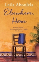
£14.95
106km hiking route in the mountains north of Barcelona. The route is presented on six handy size, 42x 30cm maps, overprinted on a topographic base with contours at 10m intervals. The last part, from Monistrol de Montserrat to Monestir de Montserrat is shown at 1:10, 000. On the reverse of each map is a description of the relevant stage & a route profile. The maps come with an illustrated booklet describing various aspects of the area stage by stage. The text both on the reverse of the maps & in the booklet

Includes::
English. The booklet also provides details of local accommodation, including campsites, refuges & private apartments, restaurants & information centres.

...
Archived Product
£12.99
Topographic survey of Catalonia at 1:25, 000 from the Institut Cartogràfic i Geològic de Catalunya, an attractive alternative to Spain’s national topographic survey at this scale, offering a much larger area per sheet with extensive tourist information & vivid presentation of vegetation & land use. These large, detailed maps have contours at 10m intervals enhanced by hill shading & fine colouring and/or graphics to portray of vegetation or land use (different types of woodlands, marshl&, vineyards, crops, etc). An overprint highlights waymarked local & long-distance GR footpaths plus CT cycling routes. Also highlighted are picturesque locations such as villages, isolated buildings or natural features. A very wide range of symbols indicate various facilities, places of interest & recreational sites: tourist information centres, campsites & other rural accommodation, cultural heritage, vineries, wildlife observation areas, viewpoints & beauty spots, sites for recreational pursuits including horse riding, water sports, paragliding, etc The maps are divided by the publishers into three types: Administrative Units, Natural Protected Areas, & Geographical Areas, as shown on our grid for this series. Coverage by each sheet varies; most maps present an area of 30 x 23km (19 x 14km approx). The maps have a 1km UTM grid, with latitude & longitude values shown for the map corners. Excellently presented topographic map legend is in Catalan only but the legend for the tourist information & the road network

Includes::
English. To see the list of all the titles in this series please click on the series link.

...
Archived Product
£31.00
ELSE/WHERE: MAPPING explores the importance of maps as aids to navigation, understanding, & cultural representation. Traditionally written by history`s victors, maps are gaining new currency in our information-saturated age as a means of making arguments & processes visible. Mapping technologies today are as diverse as the agendas driving them: the human body is mapped with 3-D software, buildings are mapped with lasers, & cities are mapped by satellite. ELSE/WHERE: MAPPING proposes-by visual example & written analysis-that mapmaking is a fundamental design process, one that shapes the physical & conceptual

Dimensions of contemporary multicultural society. ELSE/WHERE: MAPPING is the second installment in an international visual/verbal collaboration focusing on the design implications of new technologies. It follows the award-winning book IF/THEN: PLAY, published in 1999, & is designed by Amsterdam studio Mevis + van Deursen.

...
Archived Product
£2.95
Elsecar in 1901 in a fascinating series of reproductions of old Ordnance Survey plans in the Alan Godfrey Editions, ideal for anyone interested in the history of their neighbourhood or family. Selected towns in Great Britain & Ireland are covered by maps showing the extent of urban development in the last decades of the 19th & early 20th century. In this title: the map covers the villages of Elsecar & Jump, south-east of Barnsley, together with several nearby hamlets. Coverage stretches from Jump eastward to Tingle Bridge, & southward to Elsecar Green. Features at Jump include St George's church, Milton Square, Kitroyd, Jump Valley, Arundel View, Flying Dutchman pub. Features at Elsecar include Holy Trinity church, Elsecar Green, Station Row, Old Row, Elsecar Works, Distillery Row, Simon Wood Colliery, Fitzwilliam Street, Reform Row, Cobcar Terrace. Railways include the GCR Elsecar Branch with Elsecar Goods station, & the Midland Railway Chapeltown Branch Extension with Elsecar & Hoyland station. Two railway inclines are shown, plus a good stretch of the Dearne & Dove Canal's Elsecar Branch. The following hamlets are included: Hemingfield, Tingle Bridge, St Helen's, Stubbin, Stubbin Bottom, New Houses (in the south-western corner). The eastern part of Hoyland Nether is shown with its Town Hall, Manor House & King Street. Directories for Elsecar, Nether Hoyl&, Hemingfield & Jump are on the reverse. About the Alan Godfrey Editions of the 25 ...
Archived Product
£11.99
Topographical survey of Belgium at 1:20, 000 from Nationaal Geografisch Instituut / Institut Géographique National, the country’s national survey organization. Each 20K map covers one quarter of the corresponding 1:50, 000 map (with adjustments in the border & coastal areas). The maps provide all the information expected of topographic mapping at this scale & in addition have an unusually large amount of vegetation and/or land use information (different types of woodlands, gardens, orchards, heath, etc). The maps have a 1-km UTM grid, with margin ticks for latitude & longitude at intervals of 1`. Map legend & a glossary of terms used on the maps include English. Stanfords keeps as regular stock 20K maps for the World War I battlefields around the Ypres, Messines & Passchendaele, & for the area of the Battle of Waterloo. The 1:20, 000 survey covers the whole of Belgium & maps for other regions can be supplied as special orders. To see the list of titles in this series please click on the series link.PLEASE NOTE: the Long-Distance Footpaths Map of Belgium at 1:300, 000 which shows the division of Belgium into the 50K survey sheets can also be used to see in more detail coverage by the 20K maps. ...
Archived Product
£9.99
Elsie Piddock is a born skipper. By the age of seven, news of her skipping talents has reached the fairies & they invite her to Mount Caburn for lessons. The High Skip, the Slow Skip, the Skip Double-Double, the Long Skip, the Strong Skip, the Skip Against Trouble... Elsie Piddock learns them all, & soon there`s not a mortal or fairy to touch her. Many, many years later, a greedy Lord buys Mount Caburn & threatens to build factories on its l&. Can Elsie Piddock save the skipping ground for the next generation? Sparkling with charm & a liberal sprinkling of fairy dust, Elsie Piddock`s story is one to be cherished. ...
Archived Product
£8.99
A biography of the writer, broadcaster, conservationist & chronicler of colonial Kenya, whose memoir The Flame Trees of Thika (1959) achieved worldwide fame when made into a television drama series in 1981. Colonial Kenya inspired three great writers
- Karen Blixen (Out of Africa), Beryl Markham (West with the Night) & Elspeth Huxley. Huxley's writings (30 books in all: novels, biographies, & political accounts) have great political & social range, encompassing (in her Kenyan books) the exploits of the Happy Valley farmers
- made famous by James Fox's book White Mischief, poor white farmers & the lives of Africans alike. After a childhood spent in East Africa & wartime Britain, Elspeth married Gervas, a grandson of Thomas Huxley & cousin to Julian & Aldous Huxley, whom she knew well. She also later got to know Joy Adamson & the Leakeys. She travelled widely with her husband (an executive with the Empire Marketing Board) & wrote while constantly on the move. She worked for the BBC in World War II & became a Kenyan government adviser. In 1938 she bought a farm in Wiltshire, where she died in 1997. The author, Christine Nicholls, has access to all her letters & papers, & is familiar with many of the people & places in the book. Elspeth Huxley was a compelling personality & a brilliant letter-writer, extraordinarily energetic & effective in everything she did.

...
Archived Product
£2.75
Black & white street plan covering Elstree, Borehamwood & Shenley at Approx. 1:12, 400 scale with half-mile grid squares, & Radlett & Shenley together at Approx. 1:21, 000 scale. Both of these areas have street indexes. Shows some landmarks, public buildings such as schools, railway stations & police stations, & some notable private buildings & inns. Also

Includes::
a road map of Hertfordshire, covering Bishop's Stortford, Luton, Ayelsbury, Welwyn Garden City, Watford & North London at Approx. 1:250, 000.

...
Archived Product
£3.50
Elstree in 1895 in a fascinating series of reproductions of old Ordnance Survey plans in the Alan Godfrey Editions, ideal for anyone interested in the history of their neighbourhood or family. The map covers the area from Elstree village eastward to Woodcock Hill, & northward to the southern end of Elstree & Borehamwood station. Features include Elstree village, Hill House, St Nicholas church, Edgwarebury House, Deacons Hill, Woodcock Hill, Elstree Tunnel, Allum Lane, & the Artichoke pub. On the reverse are directories of Elstree in 1895 & of Little Stanmore with Edgware in 1890. This map is also Hertfordshire sheet 45.05 About the Alan Godfrey Editions of the 25” OS Series: Selected towns in Great Britain & Ireland are covered by maps showing the extent of urban development in the last decades of the 19th & early 20th century. The plans have been taken from the Ordnance Survey mapping & reprinted at about 15 inches to one mile (1:4, 340). On the reverse most maps have historical notes & many also include extracts from contemporary directories. Most maps cover about one mile (1.6kms) north/south, one & a half miles (2.4kms) across; adjoining sheets can be combined to provide wider coverage.FOR MORE INFORMATION & A COMPLETE LIST OF ALL AVAILABLE TITLES PLEASE CLICK ON THE SERIES LINK. ...
Archived Product
£3.50
Elswick in 1894 in a fascinating series of reproductions of old Ordnance Survey plans in the Alan Godfrey Editions, ideal for anyone interested in the history of their neighbourhood or family. Two maps have have been published for this area to show how it has changed over the years. Coverage stretches from Hodgkin Park eastward to Park Road, & from Sceptre Street southward to the Dunston riverside. Elswick Road & Scotswood Road run through the map, & features include the massive Elswick Works, NER railway with station, Elswick Colliery, St Joseph`s House, Elswick House, Elswick Hall, The Gables, Elswick Shipyard, South Benwell, New Benwell, Paradise, South Benwell Electric Light Works, Delaval Colliery, St John`s Cemetery, Wansbeck Home, etc; a smaller area south of the Tyne is also included, showing part of Dunston with a stretch of the NER Redheugh Branch, Atlas Rivet Works, Dunston Engine Works, saw mills, landing stages, etc. About the Alan Godfrey Editions of the 25” OS Series: Selected towns in Great Britain & Ireland are covered by maps showing the extent of urban development in the last decades of the 19th & early 20th century. The plans have been taken from the Ordnance Survey mapping & reprinted at about 15 inches to one mile (1:4, 340). On the reverse most maps have historical notes & many also include extracts from contemporary directories. Most maps cover about one mile (1.6kms) north/south, one & a half miles (2.4kms) across; adjoining sheets can be combined to provide wider coverage.FOR MORE INFORMATION & A COMPLETE LIST OF ALL AVAILABLE TITLES PLEASE CLICK ON THE SERIES LINK. ...
Archived Product

Elsewhere, Home

Longlisted for The People`s Book Prize 2018Intimate stories of longing and exile by one of our finest contemporary writers. A lonely housewife fascinated with a famous writer learns to find her own voice in Abu Dhabi; a bus route passing the Christmas lights along Oxford Street is a stark reminder for a female passenger of her brother`s tragic death on the eve of his wedding; and a Scottish man working in a kebab shop and his girlfriend try desperately to reconcile Islam`s place in their fragile relationship.From the heat of Khartoum at the height of summer to the wintery streets of London, from the concrete high rises in the Gulf to the blustery coast in Aberdeen, this elegant and moving collection vividly evokes the overlapping worlds of Africa, Britain and the Middle East.
Beautifully observed and written with empathy, Leila Aboulela`s stories deftly capture the search for home in our fast-changing world.
RIP - This product is no longer available on our network. It was last seen on 25.09.2019

This page now acts as a permanent archive for this product. Add more information using the comments box below to ensure it can still be found by future generations.

Use our search facility to see if it is available from an alternative contributor.
  • External links may include paid for promotion
  • Availability: Out Of Stock
  • Supplier: Stanfords
  • SKU: 9781846592119
Availability: In Stock
£8.99

Product Description

Longlisted for The People`s Book Prize 2018 Intimate stories of longing & exile by one of our finest contemporary writers. A lonely housewife fascinated with a famous writer learns to find her own voice in Abu Dhabi; a bus route passing the Christmas lights along Oxford Street is a stark reminder for a female passenger of her brother`s tragic death on the eve of his wedding; & a Scottish man working in a kebab shop & his girlfriend try desperately to reconcile Islam`s place in their fragile relationship. From the heat of Khartoum at the height of summer to the wintery streets of London, from the concrete high rises in the Gulf to the blustery coast in Aberdeen, this elegant & moving collection vividly evokes the overlapping worlds of Africa, Britain & the Middle East. Beautifully observed & written with empathy, Leila Aboulela`s stories deftly capture the search for home in our fast-changing world.

Reviews/Comments

Add New

Intelligent Comparison

Oooops!
We couldn't find anything!
Perhaps this product's unique.... Or perhaps we are still looking for comparisons!
Click to bump this page and we'll hurry up.

Price History

Vouchers

No voucher codes found.
Do you know a voucher code for this product or supplier? Add it to Insights for others to use.

Facebook

Jargon Buster

Contemporary - Modern era design
Contemporary - A design reference to indicate post war modern design
Heat - A term used to define thermal energy
Summer - The season between Spring and Autumn. Usually the hottest season of the year
World - A physical grouping, commonly used to describe earth and everything associated with ti
Contemporary - An object that is living in the same time.
Home - A place of permanent residence for families.

Supplier Information

Stanfords
Stanfords was established in 1853 and opened their iconic Covent Garden flagship store in 1901. They have become the top retailer of maps, travel books and accessories in the UK and arguably offer the largest selection of maps and travel books worldwide. Famous names such as Captain Robert Falcon Scott, Ranulph Fiennes and Michael Palin have purchased from Stanfords. They now have a shop in Bristol and both stores together with other venues operate a calendar of events including talks, book signings and exhibitions. As a specialist map retailer, the map selection is comprehensive and includes road maps, street maps and walking maps from worldwide destinations, as well as a selection of world atlases and wall maps. Books include travel guides and travel literature. Stanfords also stock globes, from miniatures made of blue marble to magnificent floor-standing globes. The website features a selection of interesting articles on travel topics.
Page Updated: 2023-11-12 20:15:36

Community Generated Product Tags

Oh No! The productWIKI community hasn't generated any tags for this product yet!
Menu