
 United Kingdom
 France
 Germany
 Netherlands
 Sweden
 USA
USA
 Italy
Italy
 Spain
Spain
More From Contributor


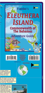
Eleuthera Island - Bahamas Adventure Map-Guide
Eleuthera Island in the Bahamas on an adventure map/guide from Franco Maps – publishers who specialize in maps with extensive information for diving and snorkeling. On the reverse are enlargements of parts of Eleuthera, plus a map of the whole of the Bahamas.On one side is a map of Eleuthera Island annotated with both places of interest on land and locations of numerous diving and snorkelling sites in its coastal waters. The sites are annotated with brief descriptions, indicating, where appropriate, the depth in metres and feet. Three monthly graphs show air temperature and precipitation, water temperature and colour, and water visibility. The map is decorated with lovely colour drawings of numerous species of fish found in the surrounding seas.On the reverse, enlargements
accompanied by descriptions show in greater detail Harbour Island with Dunmore Town, Governor’s Harbour (with a locator of 80 facilities) and Rock Sound. Also provided is a map of the whole Bahamas archipelago with brief notes about most of the islands.
accompanied by descriptions show in greater detail Harbour Island with Dunmore Town, Governor’s Harbour (with a locator of 80 facilities) and Rock Sound. Also provided is a map of the whole Bahamas archipelago with brief notes about most of the islands.

Product Description
Reviews/Comments
Add New
Vouchers
No voucher codes found.
Do you know a voucher code for this product or supplier? Add it to Insights for others to use.
Do you know a voucher code for this product or supplier? Add it to Insights for others to use.
 Denmark