More From Contributor
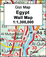
£16.99
Egypt Eyewitness travel guide from Dorling Kindersley is a lavishly illustrated book concerned with providing the visitor with detailed background information to sightseeing in the country & a broad cultural introduction. Popular historical buildings & museums are often described with cutaway diagrams allowing you to view ...
Archived Product
£16.99
The DK Eyewitness Travel Guide: Egypt is your indispensable guide to this beautiful part of the world. The fully updated guide


...
Archived Product
£10.99
Freytag & Berndt’s Egypt road map at a scale of 1:800, 000 is a place indexed, double sided, folded sheet map & comes with additional city maps, in an attached booklet, of Alexandria & Aswan at 1:15, 000, & Cairo & Sharm el-Sheikh at 1:10, 000. The road network in Egypt is shown, with motorway & duel carriage ways labelled with both route numbers & distance markers in kilometres. Primary & secondary roads, as well as tracks are shown. Main & subsidiary rail lines, car ferry routes & international & domestic airports are marked. The coverage of the map extends to displaying the main transport routes into Egypt from bordering countries. Concentration has been given to displaying the topographical water & desert features of the landscape, with lakes, salt marches, wadis, canals, salt lakes & swamps all differentiated. Places of particular interest are shown on the road map: notable buildings, castle ruins, archaeological sites. Oil fields are also located. Lines of latitude & longitude are given at 60’/1 degree intervals. ...
Archived Product
£24.95
The land that is now Egypt nurtured an extraordinary pioneering civilization
- one of the oldest, most powerful, long-lasting
...
Archived Product
£9.99
Egypt at 1:1, 200, 000 on light, waterproof at tear-resistant map published by Freytag & Berndt in their “ World Compact” series which combines a country map with street plans & extensive tourist information: descriptions of places of interest, a fact-box, etc. The map is double-sided, with a good overlap between the sides, but does not cover the whole country. In the east the whole of the Sinai Peninsula & most of the Red Sea coast is included. West of the Nile Valley, in the northern half coverage extends along the Mediterranean coast just beyond Alexandria to include Abu Mena, with the Siwa Oasis shown as an inset; the southern half stretches beyond Al Karga. Topography is shown by very effective relief shading with spot heights, graphics for salt lakes, swamps, deserts, oasis, water wells, etc, & plenty of names of geographical features. National parks & other protected areas are highlighted. Road network

Includes::
desert tracks & gives distances on main routes. Railway lines are included & local airports are marked. Also shown are internal administrative boundaries with names of the provinces. Icons indicate various places of tourist interest such as campsites, UNESCO World Heritage sites, other historical & archaeological sites, hot springs, beaches, etc. The map is indexed & has latitude & longitude lines drawn at 1° intervals.A special feature of Freytag & Berndt’s World Compact series are additional street plans & information panels, illustrated with colour photos, with descriptions of main tourist destinations, important natural features, facts & figures about the country, a phrase book, tourist tips, etc. The map of Egypt

Includes::
street plans of central Cairo, Alexandria, Aswan & Sharm El Sheikh. Map legend & all the text in the information panels is bilingual English – German.


...
Archived Product
£8.99
Egypt in New Holland’s Globetrotter Travel Guide series, comprising a range of practical & accessible guides to a number of cities, regions & countries worldwide. Globetrotter guides incorporate essential information in an easy-to-carry & easy-to-reference format. They provide visitors with an introduction highlighting the country’s ‘must see’ areas, allowing readers to make the most of their time away. Presented in a paperback PVC format, each guide in the series provides vital tips for visitors &

Includes::
information on the best places to stay, eat & shop, star-rated top attractions, detailed regional profiles & recommendations of the best tours & excursions. Individual titles also have a separate, pull-out overview map in the rear pocket of the guide that serves as a companion to the book itself. An introductory section profiles the destination with details of the l&, a brief history, government & economy & the people. Every chapter is summarised in the ‘ At-a-Glance’ sections at the end of each chapter. There is also a Travel Tips section at the back of each guide providing practical guidance & information on tourist information services, entry requirements, customs, health requirements, getting there, what to pack, money matters, accommodation, transport, business hours, time difference, electricity, health precautions, useful phrases, personal safety, emergencies, etiquette & tipping.

...
Archived Product
£14.99
Egypt Handbook in the Handbooks series from Footprint; comprehensive & leading guides designed & written for independent travellers who enjoy exploring off the beaten track. Footprint guides have an established reputation, built up since 1921, for catering for more adventurous & individual travellers. An unrestrictive editorial style also gives authors the freedom to capture & explore local cultures, sights & areas that are often not covered in other guides. Widely recognised for their reliability & independent writing style, Footprint guides all have the same layout. Introductory sections introduce the reader to the destination, with chapters on planning on your trip & essentials, including practical information & guidance on subjects such as when & where to go, itineraries, sport & activities, arts, getting there & around, eating & drinks, sleeping & a dedicated section on the anticipated carbon footprint involved in travelling to the destination. Each guide is organised geographically by region or country, with individual sections having a particular focus on an extensive range of sights & places of interest. Further, there are also details of accommodation, nightlife, restaurants & any notable local activities. Information boxes throughout the text give readers an insight into local customs, stories & sights of particular interest.A ‘ Background’ section explores the history, economy, government, education, culture, people, land & environment of the destination in significant depth. There is also a ‘ Footnotes’ chapter with a basic language guide for travellers & information about the author. A useful distance chart tailored to the destination is also included in the inside back cover. * Please note:* the series is gradually being revised, reverting to its previous style of ” Handbooks”, published in a hardback format. ...
Archived Product
£12.99
Egypt in the Berlitz Handbook series; comprising a range of guides providing comprehensive information on a range of international countries. Each guide is arranged by region, with individual sections on notable cities & towns in the area, in addition to ...
Archived Product
£14.99
Discover the world's oldest tourist destination with Footprint's fully revised & updated 5th edition of Egypt. Cairo, camels & citadels, belly dancing & bedouins all await the intrepid explorer; whether you want to dive the Red Sea, sail down the Nile in a felucca or uncover temples & tombs, this guide has them all. It

Includes::
a comprehensive background & history section, plus thorough listings on the best activities, where to find the best food & drink & how to get around giving the independent traveller the tools to really experience Egypt. Detailed culture, history & background sections give the traveller the opportunity to understand the culture & support the local community. This guide provides diving tips, from PADI courses to liveaboards. It describes best activities, from desert safaris to lake fishing & trekking. It features great maps to help you get around: from boats along the Nile to navigating the backstreets of Cairo. It

Includes::
a full-colour planning section to inspire travellers & provide practical advice to help find the best experiences.


...
Archived Product
£5.99
Egypt in the Compact Guide series from Insight is an accessible & handy reference guide, describing main sites & cultural highlights. Each illustrated guide

Includes::
an introductory chapter with a selection of the top ten things to do & gives visitors an insight into history, culture & geography. An extensive

...
Archived Product

Egypt Gizi Map

Egypt on an indexed map from Gizi Map with detailed presentation of the topography, excellent for exploring the country beyond the Nile Valley including the western deserts, Sinai and the coastline of the Red Sea and the Gulf of Suez.The whole country, from the Libyan border to the Gulf of Aqaba and south to the Sudanese border, is shown together. Topography is presented by altitude coloring with numerous spot heights, plus graphics for rocky outcrops, salt flats, coral reefs, symbols marking locations of oases and wells, etc. The map shows names of many deserts, plateaux, hill ranges, seasonal streams, etc.Road network includes tracks across the deserts. Railways and local airfields are shown, as well as the country’s administrative boundaries with names of the provinces.
Also marked are oil wells, pipelines, and aqueducts. Symbols highlight various places of interests, including ancient archaeological remains, religious sites, natural features, beaches and diving sites, etc, showing many places outside the traditional tourist routes. Names of towns, villages and administrative units and of most geographical features are given in both the Roman and Arabic alphabets. The map is indexed and has lines of latitude and longitude drawn at 1° intervals. The multilingual legend includes English and Arabic.PLEASE NOTE: this title is also available as a wall map.
RIP - This product is no longer available on our network. It was last seen on 25.09.2019

This page now acts as a permanent archive for this product. Add more information using the comments box below to ensure it can still be found by future generations.

Use our search facility to see if it is available from an alternative contributor.
  • External links may include paid for promotion
  • Availability: Out Of Stock
  • Supplier: Stanfords
  • SKU: 9789638703088
Availability: In Stock
£9.99

Product Description

Egypt on an indexed map from Gizi Map with detailed presentation of the topography, excellent for exploring the country beyond the Nile Valley including the western deserts, Sinai & the coastline of the Red Sea & the Gulf of Suez. The whole country, from the Libyan border to the Gulf of Aqaba & south to the Sudanese border, is shown together. Topography is presented by altitude coloring with numerous spot heights, plus graphics for rocky outcrops, salt flats, coral reefs, symbols marking locations of oases & wells, etc. The map shows names of many deserts, plateaux, hill ranges, seasonal streams, etc. Road network

Includes::
tracks across the deserts. Railways & local airfields are shown, as well as the country’s administrative boundaries with names of the provinces. Also marked are oil wells, pipelines, & aqueducts. Symbols highlight various places of interests, including ancient archaeological remains, religious sites, natural features, beaches & diving sites, etc, showing many places outside the traditional tourist routes. Names of towns, villages & administrative units & of most geographical features are given in both the Roman & Arabic alphabets. The map is indexed & has lines of latitude & longitude drawn at 1° intervals. The multilingual legend

Includes::
English & Arabic.PLEASE NOTE: this title is also available as a wall map.

Reviews/Comments

Add New

Price History

Vouchers

No voucher codes found.
Do you know a voucher code for this product or supplier? Add it to Insights for others to use.

Facebook

Jargon Buster

Oil - A hydrophobic liquid with high carbon and hydrogen content. Has many variations including; cooking oils, petrochemical oils, essential oils.
Graphics - A general term for visual aspects of an item/display
Wall - A physical barrier between two areas
Red - One of the three primary colours
Railways - A set of tracks that have been laid for the purpose of trains to travel up and down them
Natural - not manmade
Network - A link and communication between things. Often computers or people.
Road - a manmade lane or a path that is used to speed up travel.
Traditional - Something that has become the same through a period of time and thus repeated.
Traditional - Something that has been around for a while and is repeated regularly.
Altitude - Something that can be quite high in relation to sea or ground level.

Supplier Information

Stanfords
Stanfords was established in 1853 and opened their iconic Covent Garden flagship store in 1901. They have become the top retailer of maps, travel books and accessories in the UK and arguably offer the largest selection of maps and travel books worldwide. Famous names such as Captain Robert Falcon Scott, Ranulph Fiennes and Michael Palin have purchased from Stanfords. They now have a shop in Bristol and both stores together with other venues operate a calendar of events including talks, book signings and exhibitions. As a specialist map retailer, the map selection is comprehensive and includes road maps, street maps and walking maps from worldwide destinations, as well as a selection of world atlases and wall maps. Books include travel guides and travel literature. Stanfords also stock globes, from miniatures made of blue marble to magnificent floor-standing globes. The website features a selection of interesting articles on travel topics.
Page Updated: 2023-11-12 20:15:36

Community Generated Product Tags

Oh No! The productWIKI community hasn't generated any tags for this product yet!
Menu