More From Contributor
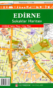
£4.50
Double-sided illustrated tourist map of Edinburgh, ideal for sightseeing. On one side is a map at 1:4, 500 scale, showing street names, historical notes, bus routes, illustrations of famous buildings & also sights of interest such as theatres, cinemas, bars, restaurants, art galleries etc. On the reverse side the map shows busy & popular areas at larger scale for extra clarity & detail, including: Princes Street & Georges Street; Edinburgh Castle; Victoria Street & Grassmarket; the Royal Mile; Edinburgh Castle; Royal Botanic Gardens; Newington; Leith; Edinburgh Airport. The map is fully indexed with legend. ...
Archived Product
£9.99
Reproduction of “ Johnston’s Plan of Edinburgh, Leith, Portobello & Environs, constructed from the latest surveys with additions by the local surveyors of these towns by W. & A.K. Johnston, Edinburgh & London, 1893”. Hachures splendidly present Arthur’s Seat & the hills south of the town: Balckford Hill, Braid Hill & the two Craiglockhart Hills. The scale is already shown as both ratio & imperial measurements. The map is supplied in a handsome card envelope with notes on the city’s expansion around the time of its publication, on the various individuals connected with its publication, etc. ...
Archived Product
£25.00
Maps can tell much about the story of a place that traditional histories fail to communicate. This is particularly true of Edinburgh, one of the most visually stunning cities in Europe & a place rich in historical & cultural associations. This lavishly illustrated book features 80 maps of Edinburgh which have been selected for the particular stories they reveal about different political, commercial & social aspects. Together, they present a fascinating insight into how Edinburgh has changed & developed over the last 500 years, & will appeal to all those with an interest in Edinburgh & Scottish history, as well as other audiences
- those interested in urban history, architectural history, town planning & the history of cartography.
...
Archived Product
£45.00
Geoplan Postcode Sector maps provide high-detail local mapping of the UK overlaid with postcode sectors, country boundaries & larger postcode groupings. They are durable & laminated, so you can draw on them in non-permanent markers & wipe them clean. They are the market-leader postcode maps for marketing, statistical display, route-planning, strategy & many other business uses. The base map uses the latest Ordnance Survey Landranger cartography, which provides detailed geographic data including motorways, A & B roads, streets, & detailed feature types such as airports, railway stations, cities, towns, geographic names, heights (using contour lines), information centres, parking facilities & much more. The base map is light & subtle but clear, readable & now in colour. Postcode/county boundaries & labels are overlaid in a bold red. The Postcode system divides the UK into Areas, Districts & Sectors. Geoplan publish maps covering all of these levels. These Sector maps cover 37 small areas of the UK, showing postcode Sectors (like HG3 1, B10 9, WC2 9 etc), their larger Districts (HG3, B10, WC2 etc) & the even larger Areas (HG, B, WC etc) ...
Archived Product
£2.99
This work contains the stories of the many closes & wynds of the Royal Mile in Edinburgh, from the castle to the palace. It is written with all the knowledge & experience the Witchery Tours have gathered in 15 years of answering queries, & is full of quirky, fun & interesting stories. ...
Archived Product
£9.99
Two Kosovo journeys a century apart. In 1900 Europe`s last wilderness was explored by a most unlikely champion, a stout, stubborn Englishwoman who travelled in her tam o`shanter across the Accursed Mountains into Kosovo. Edith Durham was dubbed ` Queen of the Highlanders` by the Albanians who honoured her for her anthropological writing, her humanitarian aid & her tireless lobbying for their cause. One hundred years later, Elizabeth Gowing came to Kosovo & also fell in love with the country. Dividing her time between there & London, she thought that no-one would understand her identity crisis; but as Elizabeth unravels Edith`s story through archives & museum collections in Britain & retraces Edith`s steps in Kosovo she learns from her what she should do with her life. Tracing the revelations in old diaries, jolting along Kosovan roads in a `motokultivator`, learning from Edith the secrets of the harem, & from monks the treasures of Unesco World Heritage Site monasteries, Elizabeth travels on Edith`s trail & ends up finding not only an Edwardian heroine but also a guide to her own very twenty-first century dilemma. Elizabeth`s first book, Travels in Blood & Honey; becoming a beekeeper in Kosovo (Signal Books, 2011) was described by The Times as `a sheer delight; a beguiling, bittersweet story of a lively love affair with a traditional world
- in transition to new nationhood`, & by The Lady as `a bold, unique stride across genres
- with a sense of humour & Famous Five enthusiasm`

...
Archived Product
£36.95
Military topographic survey mapping with contours. These maps are designed primarily as flying charts for aircraft, but they are useful as general topographical maps where nothing else is available. Contours are shown in feet, with elevation colouring & spot heights. Towns, villages, major roads, railways & airports are shown (but please note that many of the smaller settlements are not named, & the road information is not necessarily up to date). Some air navigation information also appears on the map, such as radio beacons & restricted flying zones. Double-sided sheet. ...
Archived Product
£23.99
Street atlas of Edmonton & northern Alberta, including Beaumont, Bonnyville, Camrose, Cold Lake, Devon, Drayton Valley, Edson, Fort Mc Murray, Fort Saskatchewan, Grande Prairie, Hinton, Jasper, Lacombe, Leduc, Lloydminster, Morinville, Nisku, Peace River, Ponoka, Red Deer, Rocky Mountain House, St. Albert, St. Paul, Sherwood Park, Slave Lake, Stettler, Stony Plain, Sylvan Lake, Vegreville, Wainwright, Wetaskiwin & Whitecourt. The atlas is part of an extensive coverage of Canadian cities & towns from the country’s largest map publisher, Map Art. The mapping is usually at 1:25, 000 or 1:31, 250. Colouring distinguishes general build-up areas, shopping centres, public buildings & institutions, historical sites & places of interest, parks, etc. One way streets & pedestrian zones are indicated & a wide range of symbols shows parking facilities, bus terminals, metro and/or railway stations, various public facilities & services, places of interest, recreational centres, etc. Local neighbourhoods are named & municipal & quadrant boundaries are marked. In titles covering more than one city or town, each section is accompanied by overview maps indicating areas covered by the street plans. Each title has a full street index for all localities covered by it. Map legend is either bilingual in English & French or in English only.* Please note:* following a number changes among Canadian cartographic publishers maps previously published by Map Art Publishing may now be available under one of the following imprints: Map Art, Canadian Cartographics Corporation or JDM Géo Inc. Within a series, therefore, some titles may still be published as Map Art whilst others will be available as Canadian Cartographics Corporation or JDM Géo Inc. ...
Archived Product
£10.99
Waterproof & tear-resistant Fast Track map presenting in a handy-size format a street plan of Edmonton & a road map of most of the Jasper National Park, both at 1:250, 000, plus a more detailed street plan of downtown Edmonton. On one side a street plan at 1:250, 000 covers Edmonton with its outer suburbs, highlighting various facilities & places of interest. The downtown part of the city is also presented in mote detail at 1:25, 000. On the reverse a map at 1:250, 000 covers the main road linking Edmonton with the Jasper National Park in the Rocky Mountains. Also provided are street plans of Jasper, Edson & Hinton. The main maps at 1:250, 000 both have a 10km UTM grid & a joint index listing communities, roads, parks, places of interest & ski areas. To see the list of currently available Canadian province & regional maps form the Map Art / Canadian Cartographics Corporation / JDM Géo publishing group, including waterproof & tear-resistant Fast Track titles, please click on the series link. ...
Archived Product
£10.99
Edmonton on an indexed, double-sided, waterproof & tear-resistant Fast Track map presenting the city’s central districts & Sherwood Park at 1:30, 000, with an enlargement showing in greater detail Edmonton’s downtown area at 1:15, 000, plus a map of the Edmonton conurbation at 1:250, 000. Street plans from the Map Art / Canadian Cartographics Corporation / JDM Géo publishing group are usually produced at scales around 1:25, 000 to 1:35, 000 with smaller towns often shown at more detailed scales. All plans have street indexes. Plans of larges cities usually include an enlargement for the downtown area. Plans grouping together several smaller towns often have an overview map showing the whole of the relevant region. The plans have colouring to indicate commercial, institutional or industrial use, etc. Main traffic arteries are highlighted & one way streets are marked. A range of symbols shows, as appropriate, parking facilities, bus terminals, metro and/or railway stations, various public facilities & services, places of interest, recreational centres, etc. Map legends for cities & towns in the French speaking part of the country are sometimes in French only. To see the list of currently available Canadian street plans & pocket atlases form the Map Art / Canadian Cartographics Corporation / JDM Géo publishing group, including waterproof & tear-resistant Fast Track titles, please click on the series link. ...
Archived Product

Edirne

Edirne at 1:7, 750 from Mepmedya is an indexed, double-sided street map of the historic city formerly known as Hadrianopolis. Shows main roads, streets and many places of interest. *Map legend also in English.* Main roads and streets are named and/or numbered; and many more streets are shown but not named. Railway lines are displayed and local bus stations and car parks are marked.Local districts are named and demarcated, many places of interest are annotated on the map. These include: hotels, shops, museums, historic sites and religious buildings; consulates, emergency services, libraries and university buildings; and parks, sports and entertainment venues.The map coverage appears on two side of the sheet, with a north-south split far south of the historic centre (slight
overlap).An index on the map lists streetnames and a small inset shows the location of the city within Edirne Province.
RIP - This product is no longer available on our network. It was last seen on 25.09.2019

This page now acts as a permanent archive for this product. Add more information using the comments box below to ensure it can still be found by future generations.

Use our search facility to see if it is available from an alternative contributor.
  • External links may include paid for promotion
  • Availability: Out Of Stock
  • Supplier: Stanfords
  • SKU: 9789759137335
Availability: In Stock
£8.99

Product Description

Edirne at 1:7, 750 from Mepmedya is an indexed, double-sided street map of the historic city formerly known as Hadrianopolis. Shows main roads, streets & many places of interest. * Map legend also in English.* Main roads & streets are named and/or numbered; & many more streets are shown but not named. Railway lines are displayed & local bus stations & car parks are marked. Local districts are named & demarcated, many places of interest are annotated on the map. These include: hotels, shops, museums, historic sites & religious buildings; consulates, emergency services, libraries & university buildings; & parks, sports & entertainment venues. The map coverage appears on two side of the sheet, with a north-south split far south of the historic centre (slight overlap). An index on the map lists streetnames & a small inset shows the location of the city within Edirne Province.

Reviews/Comments

Add New

Price History

Vouchers

No voucher codes found.
Do you know a voucher code for this product or supplier? Add it to Insights for others to use.

Facebook

Jargon Buster

Entertainment - Something that provides amusement
Car - A machine used for transport which runs on roads
Small - something that takes up less space than normal.

Supplier Information

Stanfords
Stanfords was established in 1853 and opened their iconic Covent Garden flagship store in 1901. They have become the top retailer of maps, travel books and accessories in the UK and arguably offer the largest selection of maps and travel books worldwide. Famous names such as Captain Robert Falcon Scott, Ranulph Fiennes and Michael Palin have purchased from Stanfords. They now have a shop in Bristol and both stores together with other venues operate a calendar of events including talks, book signings and exhibitions. As a specialist map retailer, the map selection is comprehensive and includes road maps, street maps and walking maps from worldwide destinations, as well as a selection of world atlases and wall maps. Books include travel guides and travel literature. Stanfords also stock globes, from miniatures made of blue marble to magnificent floor-standing globes. The website features a selection of interesting articles on travel topics.
Page Updated: 2023-11-12 20:15:36

Community Generated Product Tags

Oh No! The productWIKI community hasn't generated any tags for this product yet!
Menu