More From Contributor

£9.99
Edinburgh 1956-1957 map from Cassini reproducing old Ordnance Survey mapping of Scotland presented in a format designed to offer a convenient comparison with the present day coverage from the OS. Old maps have been combined so that the sheet lines correspond to the current Landranger series map No. 66 & are reproduced with the scale changed from one inch to one mile to 1:50, 000. Cassini historical maps present the city & the surrounding area at 1:50, 000 as mapped by:* Scottish First Edition 1857-1869 in black & white & with relief shown by hachuring* Scottish Third Edition 1905-1907* Scottish Popular Edition 1926-1928 with contour lines & colouring to indicate woodlands, parks, etc* OS Seventh Series 1956-1957 Each map

Includes::
notes on the development of Ordnance Survey & the various series produced by them. For those interested in maps & cartography in general, the Cassini series also provides a fascinating insight into how Ordnance Survey cartographic style has developed over a period of over 100 years. Coverage on the four 1:50, 000 maps is this set

Includes::
present day North Berwick, Musselburgh, Dalkeith, Penicuik, Loanhead, Carlops, Waterheads, Oxton, Temple, Fala, Gorebridge, Balerno, Pathhead, Pencaitl&, Gifford, Haddington, Prestonpans, Londniddry, Drem, Gullane, Kinghorn, Butntisland & Aberdour, with Pentland Hills, Lammermuir Hills & Moorfoot Hills, Hartside Hill, Gladhouse Reservoir, Threipmuir Reservoir, the Firth of Forth, Aberlady Bay & Cramond Isl&.* PLEASE NOTE: Stanfords can also print on request mapping from all four series *centring the map on a location of your choice.* For more information please click on the link below.


...
Archived Product
£5.95
Edinburgh in the Wallpaper City Guide series, published by Phaidon & encompassing a collection of pocket-size guides dedicated to the best design elements in major cities. Compiled by experts at the Wallpaper magazine, the guides are widely recognized for appealing to design-conscious travellers & are aimed at those interested in art, design & architecture. Each guide identifies the best bars, restaurants, hotels, places to shop, leisure activities & excursions with a unique emphasis on the finest examples of unusual architecture & design. Each Wallpaper City Guide has the same layout, with separate tabs allowing readers & travellers to access individual sections easily. The tabs consist of Landmarks, Hotels, 24 Hours, Urban Life, Architour, Shopping, Sports & Escapes. High quality colour photographs appear alongside brief descriptions of each hotel, bar or attraction, highlighting distinctive & unusual styles of architecture & design. Extra pages are provided at the back of each guide, allowing readers to record their own notes & sketches. ...
Archived Product
£7.99
Edinburgh & its environs at 1:25, 000 in a series of Walker’s Maps published by the AA with the cartography from the Ordnance Survey’s Explorer series. Coverage

Includes::
the Pentland Hills, Musselburgh, Dalkeith, Gorebridge, Temple, Penicuik, Queensferry, etc. Maps in the AA Walker’s series are identical to the OS Explorer maps & provide plenty of recreational & tourist information, indicating in England & Wales the traditional public rights of way paths, including bridleways & byways restricted or open to motorized traffic. Also shown are other routes with public access, including permissive footpaths & bridleways. For Scotl&, where different access rights apply, the maps provide an additional note explaining the regulations. Special marking indicates National Trails & Recreational Routes & for cyclists the maps show traffic-free routes & the National Cycle Network. A wide range of symbols highlights locations of special tourist interest: camping & caravanning sites, youth hostels, information offices & visitors’ centres, parking & picnicking places, historic buildings (indicating where appropriate National Trust, English Heritage, Historic Scotland or Cadw), sites for various recreational pursuits, country pubs, public toilets, etc. The maps provide detailed presentation of the topography with contours at 5 or 10m intervals, numerous spot heights & colouring and/or graphics for different types of vegetation. Additional colouring shows access l&, including areas managed by the National Trust, Forestry Commission & Woodland Trust. All the standard information expected of high quality survey mapping at this scale is included: finely graded road network, railway lines with stations, cuttings or embankments, individual isolated buildings, etc. For GPS users the British National Grid is drawn at 1km intervals.

...
Archived Product
£5.95
Edinburgh Premier Street Plan from Geographers` A-Z Map Company designed to cover the city within its administrative boundaries, with an enlargement for the city centre & an index listing streets, places & areas, hospitals & hospices, industrial estates, selected flats & walkways, stations, junctions, & selected places of interest, shown where appropriate with their postcodes. The city is covered at 3 1/3 inches to 1 mile (1:19, 000), with an enlargement showing the town centre in greater clarity at 6 2/3 inches to 1 mile (1:9, 500). Coverage
Includes:: Balerno, Bonnyrigg, Cramond, Currie, Dalkeith, Leith, Loanhead, Musselburgh, West Craigs & Whitegraigs. Current edition of this title was published in 2008. The plans show selected A & B roads annotated with house numbers for easier identification of addresses. One way traffic, restricted access, pedestrianized streets, selected car parks & Park & Ride facilities are marked. Railway stations are shown with names. Colouring and/or symbols indicate public building, services & facilities, including shopping centres or market streets, industrial buildings, hospitals or healthcare, etc. Public toilets are marked, indicating those with facilities for the disabled. The map also shows local authority & postcode boundaries, plus national grid lines. The index is next to the map.* This title is also available as a wall map, on paper or encapsulated.
...
Archived Product
£5.95
Edinburgh Street Atlas from the Geographers` A-Z Map Company in a paperback format slightly smaller than A5. Map scale is 1:19, 000 (3.33” to a mile), with an enlargement showing the town centre of Eastbourne in greater detail at 1:9, 500 (6.67” to 1 mile), plus a 10-page guide section describing the city’s main sights. Coverage

Includes::
Balerno, Bonnyrigg, Currie, Dalkeith, Gorebridge, Kirkliston, Lasswade, Loanhead, Musselburgh, Newtongrange, Penicuik, Prestonpans, South Queensferry & Tranent. Current edition of this title was published in 2015. To see other titles in this series of A-Z street atlases of towns & cities please click on the series link. A-Z also publish a series of County Street Atlases
- for a list of titles in that series please search for SI00000917.A-Z street atlases present motorways plus A & B roads highlighted by colouring & shown with route numbers. One way or restricted access streets & car parks are marked, as are in more recently published titles locations of speed cameras. Also shown are selected cycleway routes. Where appropriate, A & B roads are annotated with selected house numbers for easier identification of addresses. Railway lines are shown with stations & level crossings. Colouring indicates different types of buildings: educational, hospitals & healthcare, industrial, leisure & recreational, shopping centres & markets, public buildings, & places of interest. Symbols mark locations of facilities usually indicated on street mapping: post offices, emergency services, public toilets, etc. Also marked are postcode & local authority boundaries. Each page has the lines & coordinates of the British National Grid. The indexes list streets, places & areas, hospitals, industrial estates, blocks of flats on housing estates, railway stations, & selected places o interest; the latter are printed in contrasting colouring to make them easier to find.


...
Archived Product
£24.95
Edinburgh & Borders Postcode Sector Map at 1:150, 000, paper version, in a series of postcode sector maps showing the first part of the postcode & the first number of the second part, the Inward Code. An enlargement shows Edinburgh in greater detail. Coverage extends north to North: Kirkcaldy, south to Kielder, east to Farne Islands, & west to Biggar. Map Marketing’s series of postcode sector maps covers Great Britain & Northern Ireland on 36 titles, each available only as a flat map, either on paper or encapsulated for greater durability. Presentation

Includes::
postcode changes in the most recent Royal Mail Postcode updates. The series covers Great Britain at 1:150, 000 (1” to 2.4 miles), with Northern Ireland shown at 1:210, 000 & London at two scales: 1:60, 000 for the area within the M25 & in more detail at 1:15, 000 for central London. Postcode area, district & sector boundaries & numbers/letters are shown in red, with County & Unitary Authority boundaries in green. The map base shows motorways, primary, ‘A’ & down to unclassified roads, with conurbation shapes & city plan insets showing street level detail for major cities. To see the list of all the titles in this series please click on the series link.

...
Archived Product
£5.99
Whether you want to hunt for ghosts under the streets of Edinburgh, or watch sea birds off the dramatic, volcanic east coast, this area of Scotland has something for everyone. From shopping to golfing, Footprint Focus will guide you around the best restaurants, walking tours, activities & accommodation. Encompassing the medieval Old Town, the Georgian New Town & the surrounding area, Edinburgh & Lothians will ensure that you make the most of your trip. Essentials section with useful advice on getting to & around Edinburgh & Lothians. Comprehensive, up-to-date listings of where to eat, sleep & play.

Includes::
information on tour operators & activities, from ghost walks to arts festivals. Detailed maps for Edinburgh & the surrounding area. Slim enough to fit in your pocket. With detailed information on all the main sights, plus many lesser-known attractions, Footprint Focus Edinburgh & Lothians provides concise & comprehensive coverage of Scotland's most beautiful & elegant city.

...
Archived Product
£9.95
Double-sided map from ITMB combining a street plan of Edinburgh with a road map of Scotland showing the topography by altitude colouring. The Edinburgh plan at 1:10, 000 covers a wide stretch of the city extending west beyond the Murrayfield rugby stadium, eastwards beyond the Holyrood Palace & Arthur ...
Archived Product
£3.99
Edinburgh Atlas & Guide is a pocket-sized, indexed street atlas at 1:12, 000 from Collins. Shows the central areas with large amounts of tourist information & enlarged plans of the Royal Mile & Edinburgh Castle. Main roads (with road numbers) & streets are shown with an indication of one-way streets & car parks. Train stations, railway lines & some footpaths (e.g. the Water of Leith Walkway) are displayed. Many sites & buildings of interest to the tourist are indicated (such as theatres, major hotels & tourist information offices), as are post offices, libraries, places of worship & many public & commercial buildings. Parks & woodland are also displayed. The map covers central Edinburgh & some of the inner residential areas. See adjoining image for full coverage. Also
Includes:: Around 45 pages of tourist information (with map references), giving prices, facilities, opening times, contact details & background information. Also

Includes::
information about transport, accommodation, eating, drinking, entertainment & shopping. An enlarged map of the area around the Royal Mile at 1:9, 000, with greater detail of streets & places of interest. A plan of Edinburgh Castle, with tourist information. A plan of Edinburgh Airport at 1:12, 000.


...
Archived Product
£3.50
Edinburgh`s Calton Hill area in 1877 in a series of exceptionally detailed reproductions of old Ordnance Survey street plans for areas of larger cities which have undergone substantial redevelopment in the late 19th or the early 20th century, published in the Alan Godfrey Editions. The plans, printed in back & white, have been taken from the original Ordnance Survey mapping at 1:1, 056 & reproduced at 1:1, 760 – the equivalent of 36 inches (or one yard) to a mile. The maps provide an unrivalled, house-by-house picture of streets & individual buildings with inner courtyards, outbuildings, pavements, covered passages, etc. Many important institutions are named; within the National Galley on Trafalgar Square even the individual rooms (the map is from 1871, so no French Impressionists as yet!). On the reverse are historical notes about the area covered by the map, plus extracts from contemporary street directories. These maps provide a fascinating addition to Alan Godfrey’s huge series of some 2, 000 titles presenting reproductions of street plans at taken from the Ordnance Survey mapping at 1:2, 500 (25” to 1 mile) & reprinted at about 15 inches to one mile (1:4, 340). ...
Archived Product

Edinburgh And Borders Postcode Sector Map ENCAPSULATED

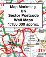
Edinburgh and Borders Postcode Sector Map at 1:150, 000, encapsulated version, in a series of postcode sector maps showing the first part of the postcode and the first number of the second part, the Inward Code. An enlargement shows Edinburgh in greater detail. Coverage extends north to North: Kirkcaldy, south to Kielder, east to Farne Islands, and west to Biggar.Map Marketing’s series of postcode sector maps covers Great Britain and Northern Ireland on 36 titles, each available only as a flat map, either on paper or encapsulated for greater durability. Presentation includes postcode changes in the most recent Royal Mail Postcode updates. The series covers Great Britain at 1:150, 000 (1” to 2.4 miles), with Northern Ireland shown at 1:210, 000 and London at two scales: 1:60,
000 for the area within the M25 and in more detail at 1:15, 000 for central London. Postcode area, district and sector boundaries and numbers/letters are shown in red, with County and Unitary Authority boundaries in green. The map base shows motorways, primary, ‘A’ and down to unclassified roads, with conurbation shapes and city plan insets showing street level detail for major cities. To see the list of all the titles in this series please click on the series link.LAMINATED and ENCAPSULATED WALL MAPS:- LAMINATED wall maps have a thin layer of plastic usually applied to the printed side only. They can be written on with suitable marker pens without any damage to the map but, unless laminated on both sides, they are not damp-proof.- ENCAPSULATED wall maps are sealed between two
sheets of plastic. They are more rigid and heavier than laminated maps of the same size. They are damp-proof and do not crinkle in humid conditions. Encapsulation gives the map a shiny surface, similar to being displayed behind glass.- PLEASE NOTE: many publishers and retailers often use these two terms interchangeably. Our map titles and descriptions follow the definitions provided above.
RIP - This product is no longer available on our network. It was last seen on 25.09.2019

This page now acts as a permanent archive for this product. Add more information using the comments box below to ensure it can still be found by future generations.

Use our search facility to see if it is available from an alternative contributor.
  • Availability: Out Of Stock
  • Supplier: Stanfords
  • SKU: 9781842520666
Availability: In Stock
£34.95

Product Description

Edinburgh & Borders Postcode Sector Map at 1:150, 000, encapsulated version, in a series of postcode sector maps showing the first part of the postcode & the first number of the second part, the Inward Code. An enlargement shows Edinburgh in greater detail. Coverage extends north to North: Kirkcaldy, south to Kielder, east to Farne Islands, & west to Biggar. Map Marketing’s series of postcode sector maps covers Great Britain & Northern Ireland on 36 titles, each available only as a flat map, either on paper or encapsulated for greater durability. Presentation

Includes::
postcode changes in the most recent Royal Mail Postcode updates. The series covers Great Britain at 1:150, 000 (1” to 2.4 miles), with Northern Ireland shown at 1:210, 000 & London at two scales: 1:60, 000 for the area within the M25 & in more detail at 1:15, 000 for central London. Postcode area, district & sector boundaries & numbers/letters are shown in red, with County & Unitary Authority boundaries in green. The map base shows motorways, primary, ‘A’ & down to unclassified roads, with conurbation shapes & city plan insets showing street level detail for major cities. To see the list of all the titles in this series please click on the series link.LAMINATED & ENCAPSULATED WALL MAPS:- LAMINATED wall maps have a thin layer of plastic usually applied to the printed side only. They can be written on with suitable marker pens without any damage to the map but, unless laminated on both sides, they are not damp-proof.- ENCAPSULATED wall maps are sealed between two sheets of plastic. They are more rigid & heavier than laminated maps of the same size. They are damp-proof & do not crinkle in humid conditions. Encapsulation gives the map a shiny surface, similar to being displayed behind glass.- PLEASE NOTE: many publishers & retailers often use these two terms interchangeably. Our map titles & descriptions follow the definitions provided above.

Reviews/Comments

Add New

Intelligent Comparison

Oooops!
We couldn't find anything!
Perhaps this product's unique.... Or perhaps we are still looking for comparisons!
Click to bump this page and we'll hurry up.

Price History

Vouchers

No voucher codes found.
Do you know a voucher code for this product or supplier? Add it to Insights for others to use.

Facebook

Jargon Buster

Paper - A thin sheet mainly used for writing. Available in a variety of colours. Made mainly from wood pulp.
Plastic - A generic term for a synthetic product used in the manufacture of products
Edinburgh - The capital city of Scotland
Glass - A solid, typically transparent. Brittle and used in windows. The first patent granted in the UK was for Glass.
Wall - A physical barrier between two areas
Mail - Or post is a service for transmitting physical objects or letters between locations
Red - One of the three primary colours
Size - is the measurement of how big an object is in space.
Layer - Adding extra quantities of materials for extra practical benefits, e.g. warmth.
Laminated - A thin layer of plastic that gives a coating and shine to a material.
Primary - the beginning of something, of chief importance.
Borders - A line that sometimes can be built up separating off an area, e.g. countries "the welsh boarder"
Shiny - A smooth reflective surface, e.g. a metal spoon.
Humid - When water vapour is high in the atmosphere making it feel stuffy.

Supplier Information

Stanfords
Stanfords was established in 1853 and opened their iconic Covent Garden flagship store in 1901. They have become the top retailer of maps, travel books and accessories in the UK and arguably offer the largest selection of maps and travel books worldwide. Famous names such as Captain Robert Falcon Scott, Ranulph Fiennes and Michael Palin have purchased from Stanfords. They now have a shop in Bristol and both stores together with other venues operate a calendar of events including talks, book signings and exhibitions. As a specialist map retailer, the map selection is comprehensive and includes road maps, street maps and walking maps from worldwide destinations, as well as a selection of world atlases and wall maps. Books include travel guides and travel literature. Stanfords also stock globes, from miniatures made of blue marble to magnificent floor-standing globes. The website features a selection of interesting articles on travel topics.
Page Updated: 2023-11-12 20:15:36

Community Generated Product Tags

Oh No! The productWIKI community hasn't generated any tags for this product yet!
Menu