
 United Kingdom
 France
 Germany
 Netherlands
 Sweden
 USA
USA
 Italy
Italy
 Spain
Spain
More From Contributor


Edgar Allan Poe`s Puzzles From Beyond The Grave
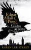
In Edgar Allan Poe`s Puzzles From Beyond the Grave, author Jason Ward re-imagines Poe`s writings to create a challengingly fiendish - and occasionally frightening - series of riddles and puzzles which are sure to get the pulses racing of even the most hardened puzzle-solvers. As the great man said: ”The true genius shudders at incompleteness.” So make sure to complete these puzzles... or risk incurring the wrath of Edgar Allan Poe himself.Step into the Gothic world of Edgar Allan Poe and become part of his terrifying tales - just long enough to solve the riddles and conundrums found there. The acclaimed American writer, who is seen as the inventor of detective fiction, created some of the best-known and most-loved macabre stories and was an expert in the art of cryptography and
mystery. Step into his world, if you dare!
mystery. Step into his world, if you dare!
Product Description
Reviews/Comments
Add New
Vouchers
No voucher codes found.
Do you know a voucher code for this product or supplier? Add it to Insights for others to use.
Do you know a voucher code for this product or supplier? Add it to Insights for others to use.
 Denmark