More From Contributor
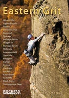
£13.99
About this series: Re-issues of A. Wainwright's classic series of h&-illustrated fell walking guides. These compact hardbacks have not been amended, so they should be used with caution & alongside up-to-date maps when walking. However, Mr. Wainwright's sheer enthusiasm for fell walking is communicated to the reader & each title will add a further dimension of enjoyment to the experience of walking in the areas they cover. This series represents a landmark in the history of walking guides & is a fitting memorial to one walker's definitive contribution to the genre. ...
Archived Product
£14.99
This is the original Pictorial Guide to the Eastern Fells of Lakeland freshly reproduced from Wainwright`s original pages. The Eastern Fells include the greatest single concentrated mass of high ground in Lakeland: a tremendous barrier running north & south, high & steep all along its length, rising to above 3000 feet on Helvellyn
- the most-often climbed mountain in the Lake District. Popular resorts such as Ambleside & Grasmere lie in this sector of the fells, as does the beautiful Patterdale valley (the best base, in Wainwright`s view, for exploring the area). The Pictorial Guides by A. Wainwright have been treasured by generations of walkers & are as enchanting & relevant now as when they were written, sixty years ago.
...
Archived Product
£14.99
One name above all others has become associated with walking in the Lake District: Alfred Wainwright, whose seven-volume Pictorial Guide to the Lakeland Fells, first published in 1955-66, has become the definitive guidebook. Wainwright`s meticulously h&-drawn maps, diagrams & drawings take walkers up the 214 principal hills & mountains of the Lake District, describing the main routes of ascent from different starting points, as well as lesser-known variants, showing the summit viewpoint panoramas & the ridge routes that can be made to create longer walks. Every page combines words & illustrations to present the routes in a way that is original, visually appealing & easy to follow. This new edition of Wainwright`s Walking Guide to the Lake District Fells has been comprehensively revised. Paths, maps, diagrams & route descriptions have been checked & corrected throughout. These revisions have been undertaken by writer & designer Clive Hutchby, author of The Wainwright Companion. The Eastern Fells, Book One of Wainwright`s Walking Guides, covers the area north of Ambleside, between Ullswater & Thirlmere, &

Includes::
the ascents of popular fells such as Helvellyn, Catstycam, Fairfield & Red Screes.

...
Archived Product
£17.50
Eastern Finland in a series of double-sided recreational outdoor maps from Karttakeskus with both national & local cycling routes, covering the southern part of the country at 1:200, 000 & the north at 1:400, 000. English translations are provided for all the information in each title. The southern part of the country up to Oulu is covered on five maps at 1:200, 000, with the area north of it on one map at 1:400, 000. Topography is shown by contours at 20m intervals with spot heights, presenting a very clear picture of the mountainous parts of Lapl&. National parks & other protected areas are prominently marked. Road network indicates unsurfaced roads &

Includes::
privately maintained local roads. Railway lines are shown with stations & ferry connections are marked. An overprint highlights both national & local waymarked cycling routes, & shows road surface, sections with a separate cycle paths, & intermediate distances. Enlargements show the routes across the main urban areas. Also marked are mountain bike routes, plus selected nature trails & canoeing routes. An extensive range of symbols provide additional information: tourist information offices; different types of accommodation, including campsites, holiday villages, youth hostels, fell huts & shelters; restaurants & shops in remote areas; cycle hire & repair shops; sport & recreational facilities, etc. The maps have a UTM grid. Each title also

Includes::
information of carrying cycles on public transport & lists of useful contact addresses. Map legend & all the text include English. In this title: street plans for Varkus, Savonlinna, Mikkeli, Imatra, Lappeenranta, Joensuu & Kuopio.PLEASE NOTE: Since 2001 Finland


...
Archived Product
£9.99
Geological map of the Eastern Graham L&, the northernmost part of the Antarctic Peninsula, at 1:625, 000 from the British Antarctic Survey. Two insets show in greater detail the region around Botany Bay & around the Sobral & Longing Peninsulas. The map also

Includes::
two geological cross sections: from near Cape Legoupil to Snow Hill Islands & from Bastion Peak to Cape Framnes. Full BAS ref. number: BAS GEOMAP 2 Series, sheet 1, edition 1, published in 2011).PLEASE NOTE: to see the list of other detailed topographic & specialist maps from BAS please click on the series link. BAS maps of wider general interest are listed on our website in a separate series.

...
Archived Product
£24.00
Climbing guide from the British Mountaineering Council, covering Froggatt to Black Rocks, some of the most popular climbs Derbyshire has to offer. The guide has an introduction to both the climbs & the history of the area, as well as basic emergency information a climber may need. The climbs themselves are arranged by route, with an overview map every few climbs marking where the climbs are in a certain area, as you (ideally) make your way from Froggatt to the Black Rocks. There is a photograph of each rock face, with the recommended climbing route overprinted. At the end of each section a small list depicting the history of the area’s ascents is also included. ...
Archived Product
£20.00
Cloth-backed reproduction of a beautiful map of the Eastern Hemisphere in the third quarter of the 19th century with cartography which will appeal instantly to all who love browsing through old atlases. The original map was drawn by Stanford’s Geographical Establishment & “published under the direction of the Committee of General Literature & Education Appointed by The Society for Promoting Christian Knowledge & of the National Society”. Individual countries are presented in gentle pastel hues typical of h&-coloured maps, with their borders outlined in stronger colours. The publication date of 1877 gives us Europe of large imperial states, much of Asia as we know it, but Africa still in the early stages colonization with its interior largely unexplored. Hachures are used to show the mountain ranges & many other features of contemporary cartography are included: ocean currents & trade winds, surrounding frames showing the tropical zones & the position of the sun, etc. Latitude & longitude lines are drawn at 10° intervals. Additional panels show the continents as viewed from the two poles, plus five of those particularly loved features of mid & late 19th century atlases
- vertical cross-sections with elevations across the continents. Each individual map in this cloth-backed version is sold folded in a colourful case covered with a unique design marbled paper – no two cases are identical.PLEASE NOTE: a wall map version of this title is available as part of the “ Stanfords Classics Collection of Historical Reproductions”. To see the full list of other titles in this fascinating series from the Old Folding Maps please click on the series link.
...
Archived Product
£9.99
Shortlisted for a 2018 Edward Stanford Travel Writing Award. Levison Wood was only 22 when he decided to hitch-hike from England to India through Russia, Iran, Afghanistan & Pakistan, but he wasn`t the conventional follower of the hippy trail. A fascination with the deeds of the early explorers, a history degree in the bag, an army career already planned & a shoestring budget of GBP750
- including for the flight home
- he was determined to find out more about the countries of the Caucasus & beyond
- & meet the people who lived & worked there. ` Eastern Horizons` is a true traveller`s tale in the tradition of the best of the genre, populated by a cast of eccentric characters; from mujahideen fighters to the Russian mafia. Along the way he meets some people who showed great hospitality, while others would rather have murdered him... This book confirms that Levison Wood, Winner of the 2016 Edward Stanford Adventure Travel Book Of The Year Award, has indeed `breathed new life into adventure travel ` (Michael Palin)


...
Archived Product
£20.00
Shortlisted for a 2018 Edward Stanford Travel Writing Award. Levison Wood was only 22 when he decided to hitch-hike from England to India through Russia, Iran, Afghanistan & Pakistan, but he wasn`t the conventional follower of the hippy trail. A fascination with the deeds of the early explorers, a history degree in the bag, an army career already planned & a shoestring budget of GBP750
- including for the flight home
- he was determined to find out more about the countries of the Caucasus & beyond
- & meet the people who lived & worked there.EASTERN HORIZONS is a true traveller`s tale in the tradition of the best of the genre, populated by a cast of eccentric characters; from mujahideen fighters to the Russian mafia. Along the way he meets some people who showed great hospitality, while others would rather have murdered him... This book confirms that Levison Wood, Winner of the 2016 Edward Stanford Adventure Travel Book Of The Year Award, has indeed `breathed new life into adventure travel ` (Michael Palin)


...
Archived Product
£7.95
Small physical road map with hill shading to show the relief. Coverage extends from the country`s eastern extremity to as far west as Tokmak & Lake Song Kel`, & from the China border to Almaty, Kazakhstan in the north. Colours distinguish vegetated areas, arid plains mountain ranges & ice fields. Major peaks are indicated & areas of special interest highlighted. ...
Archived Product

Eastern Grit

This is the third edition of the UK`s best selling guidebook - Eastern Grit. Once again the book has been expanded with more coverage of the main cliffs and the inclusion of many of the minor venues that were left out last time round. It is now comes out at a massive 520 pages with over 4000 routes! All the cliffs have been rephotographed in glorious detail, every page has been redesigned and all the descriptions and grades have been checked against the UKClimbing databases. The book includes a superb set of inspiring action photographs from some renown photographers plus a plethora of graded lists. It is full of the kind of intimate knowledge that only comes from many years of climbing on these superb gritstone cliffs. This book will reset the standard for the years to come, this the
only volume to cover the whole of the Eastern Gritstone edges from Wharncliffe to the Black Rocks and all the classic crags in between - Rivelin, the magnificent Stanage, Froggatt, Curbar, Millstone, the Burbage Valley, Birchen, Gardom`s, Cratcliffe and many more.
RIP - This product is no longer available on our network. It was last seen on 25.09.2019

This page now acts as a permanent archive for this product. Add more information using the comments box below to ensure it can still be found by future generations.

Use our search facility to see if it is available from an alternative contributor.
  • External links may include paid for promotion
  • Availability: Out Of Stock
  • Supplier: Stanfords
  • SKU: 9781873341087
Availability: In Stock
£29.95

Product Description

This is the third edition of the UK`s best selling guidebook
- Eastern Grit. Once again the book has been expanded with more coverage of the main cliffs & the inclusion of many of the minor venues that were left out last time round. It is now comes out at a massive 520 pages with over 4000 routes! All the cliffs have been rephotographed in glorious detail, every page has been redesigned & all the descriptions & grades have been checked against the UKClimbing databases. The book

Includes::
a superb set of inspiring action photographs from some renown photographers plus a plethora of graded lists. It is full of the kind of intimate knowledge that only comes from many years of climbing on these superb gritstone cliffs. This book will reset the standard for the years to come, this the only volume to cover the whole of the Eastern Gritstone edges from Wharncliffe to the Black Rocks & all the classic crags in between
- Rivelin, the magnificent Stanage, Froggatt, Curbar, Millstone, the Burbage Valley, Birchen, Gardom`s, Cratcliffe & many more.

Reviews/Comments

Add New

Intelligent Comparison

Oooops!
We couldn't find anything!
Perhaps this product's unique.... Or perhaps we are still looking for comparisons!
Click to bump this page and we'll hurry up.

Price History

Vouchers

No voucher codes found.
Do you know a voucher code for this product or supplier? Add it to Insights for others to use.

Facebook

Jargon Buster

Black - A colour which does not emit any colour of the spectrum. Black absorbs all frequencies of the spectrum.
UK - United Kingdom - An island nation in Europe
Set - a group of items usually related to one another. Some objects cannot function without the complete set of items.
Classic - Something that is still like it was originally a high quality standard.

Supplier Information

Stanfords
Stanfords was established in 1853 and opened their iconic Covent Garden flagship store in 1901. They have become the top retailer of maps, travel books and accessories in the UK and arguably offer the largest selection of maps and travel books worldwide. Famous names such as Captain Robert Falcon Scott, Ranulph Fiennes and Michael Palin have purchased from Stanfords. They now have a shop in Bristol and both stores together with other venues operate a calendar of events including talks, book signings and exhibitions. As a specialist map retailer, the map selection is comprehensive and includes road maps, street maps and walking maps from worldwide destinations, as well as a selection of world atlases and wall maps. Books include travel guides and travel literature. Stanfords also stock globes, from miniatures made of blue marble to magnificent floor-standing globes. The website features a selection of interesting articles on travel topics.
Page Updated: 2023-11-12 20:15:36

Community Generated Product Tags

Oh No! The productWIKI community hasn't generated any tags for this product yet!
Menu