More From Contributor
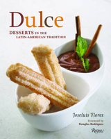
£16.99
Born the son of an impoverished sea captain in 1781, Stamford Raffles worked his way up in the East India Company to become a minor official on the island of Penang. Out of the blue, he was appointed Governor of Java, & in 1819 he founded Singapore. Now Barley puts himself in Raffles' skin to offer this portrait. 16 pages of illustrations. ...
Archived Product
£2.95
Ashton & Dukinfield in 1907 in a fascinating series of reproductions of old Ordnance Survey plans in the Alan Godfrey Editions, ideal for anyone interested in the history of their neighbourhood or family. Selected towns in Great Britain & Ireland are covered by maps showing the extent of urban development in the last decades of the 19th & early 20th century. In this title: two versions of this map have been published ...
Archived Product
£3.50
Dukinfield North in 1896 in a fascinating series of reproductions of old Ordnance Survey plans in the Alan Godfrey Editions, ideal for anyone interested in the history of their neighbourhood or family. Two versions have been published for this area: This title, the 1896 map, is blank north of the zigzagging county boundary. However, the Cheshire area, covering much of Dukinfield, is full of interest. Features here include Market Place area, Dukinfield Lodge, Cemetery, Oxford Road Mills, Sandy Vale Print Works, Wellington Mills, Tame Valley Mills, stretches of railway crossing & re-crossing the county boundary, two Dukinfield stations, St Mark`s church, Chapel Pits, Bridge Eye Mills, etc. On the reverse is a commercial directory of Dukinfield in 1898. The 1907 version also

Includes::
much of Ashton under Lyne, with coverage extending northward to Ashton Market Place & westward to St Peter`s church. Features in Ashton include Empire Hippodrome, tramways, numerous mills, St Michael`s church, Albion School, Park Parade station, good stretches of the GCR, LNWR & L&Y railways, Henry Square area, etc. About the Alan Godfrey Editions of the 25” OS Series: Selected towns in Great Britain & Ireland are covered by maps showing the extent of urban development in the last decades of the 19th & early 20th century. The plans have been taken from the Ordnance Survey mapping & reprinted at about 15 inches to one mile (1:4, 340). On the reverse most maps have historical notes & many also include extracts from contemporary directories. Most maps cover about one mile (1.6kms) north/south, one & a half miles (2.4kms) across; adjoining sheets can be combined to provide wider coverage.FOR MORE INFORMATION & A COMPLETE LIST OF ALL AVAILABLE TITLES PLEASE CLICK ON THE SERIES LINK.

...
Archived Product
£2.95
Dukinfield South in 1896 in a fascinating series of reproductions of old Ordnance Survey plans in the Alan Godfrey Editions, ideal for anyone interested in the history of their neighbourhood or family. Selected towns in Great Britain & Ireland are covered by maps showing the extent of urban development in the last decades of the 19th & early 20th century. In this title: this detailed map covers the southern part of Dukinfield, & northern fringe of Hyde. Coverage stretches from Pickford Lane southward to Bennett Street, & from Cheetham Hill Road westward to the River Tame. Please note that the small area of Lancashire west of the Tame is left blank. Features include Newton Wood area, Peak Forest Canal, Dukinfield Hall, Great Central Railway, Hyde Junction station, Bradleyhurst Farm, Barnmeadow Dyewood Mills, Dukinfield Collieries, Dewsnap Pit, Astley Deep Pit, Hyde Junction Iron Works, Johnsonbrook Mill, Victoria Colliery, St Luke's church, St Matthew's Mission Church, Plain Pit, Albert Mill etc. On the reverse is a list of private residents from an 1896 directory. About the Alan Godfrey Editions of the 25 ...
Archived Product
£3.50
Dukinfield South in 1896 in a fascinating series of reproductions of old Ordnance Survey plans in the Alan Godfrey Editions, ideal for anyone interested in the history of their neighbourhood or family. The map covers the southern part of Dukinfield & northern fringe of Hyde. Coverage stretches from Pickford Lane southward to Bennett Street, & from Cheetham Hill Road westward to the River Tame. Please note that the small area of Lancashire west of the Tame is left blank. Features include Newton Wood area, Peak Forest Canal, Dukinfield Hall, Great Central Railway, Hyde Junction station, Bradleyhurst Farm, Barnmeadow Dyewood Mills, Dukinfield Collieries, Dewsnap Pit, Astley Deep Pit, Hyde Junction Iron Works, Johnsonbrook Mill, Victoria Colliery, St Luke`s church, St Matthew`s Mission Church, Plain Pit, Albert Mill, etc. On the reverse is a list of private residents from an 1896 directory. About the Alan Godfrey Editions of the 25” OS Series: Selected towns in Great Britain & Ireland are covered by maps showing the extent of urban development in the last decades of the 19th & early 20th century. The plans have been taken from the Ordnance Survey mapping & reprinted at about 15 inches to one mile (1:4, 340). On the reverse most maps have historical notes & many also include extracts from contemporary directories. Most maps cover about one mile (1.6kms) north/south, one & a half miles (2.4kms) across; adjoining sheets can be combined to provide wider coverage.FOR MORE INFORMATION & A COMPLETE LIST OF ALL AVAILABLE TITLES PLEASE CLICK ON THE SERIES LINK. ...
Archived Product
£8.99
They are dull & proud & urge the good ordinary men of the nation to join them now. Neil collects bricks, Kevin is a roundabout enthusiast, John runs the Apostrophe Protection Society & Keith`s actual job is watching paint dry. They are members of the Dull Men`s Club & are passionate about the everyday, unglamorous things in life. Whether you have a thing for pylons or rhubarb, reclaim & celebrate the ordinary.

Includes::
Free Honorary Membership. Predictable. Reliable. Safe.

...
Archived Product
£3.50
Dulwich Village in 1870 in a fascinating series of reproductions of old Ordnance Survey plans in the Alan Godfrey Editions, ideal for anyone interested in the history of their neighbourhood or family. Three versions for this area have been published, stretching from Gallery Road eastward to Honor Oak Road, & from Camberwell Cemetery southward to Thorpewood Avenue, covering Dulwich Village, the area around Dulwich College, & much of Lordship Lane. Features include Dulwich Park, Dulwich Gallery, Adon Mount, Horniman Museum. The Crystal Palace line runs through the map with Lordship Lane & Honor Oak stations. Note that on the 1870 version a small portion of the map covering Kent is left blank. The 1913 version has been revamped in 2006 & now has more extensive street directory extracts, including directories for College Rd, Court Lane, Dulwich Village, part of Lordship Lane, Melford Road, Overhill Road, Sydenham Hill, Underhill Road & Upland Road. About the Alan Godfrey Editions of the 25” OS Series Selected towns in Great Britain & Ireland are covered by maps showing the extent of urban development in the last decades of the 19th & early 20th century. The plans have been taken from the Ordnance Survey mapping & reprinted at about 15 inches to one mile (1:4, 340). On the reverse most maps have historical notes & many also include extracts from contemporary directories. Most maps cover about one mile (1.6kms) north/south, one & a half miles (2.4kms) across; adjoining sheets can be combined to provide wider coverage.FOR MORE INFORMATION & A COMPLETE LIST OF ALL AVAILABLE TITLES PLEASE CLICK ON THE SERIES LINK. ...
Archived Product
£3.50
Dulwich Village in 1894 in a fascinating series of reproductions of old Ordnance Survey plans in the Alan Godfrey Editions, ideal for anyone interested in the history of their neighbourhood or family. Three versions for this area have been published, stretching from Gallery Road eastward to Honor Oak Road, & from Camberwell Cemetery southward to Thorpewood Avenue, covering Dulwich Village, the area around Dulwich College, & much of Lordship Lane. Features include Dulwich Park, Dulwich Gallery, Adon Mount, Horniman Museum. The Crystal Palace line runs through the map with Lordship Lane & Honor Oak stations. Note that on the 1870 version a small portion of the map covering Kent is left blank. The 1913 version has been revamped in 2006 & now has more extensive street directory extracts, including directories for College Rd, Court Lane, Dulwich Village, part of Lordship Lane, Melford Road, Overhill Road, Sydenham Hill, Underhill Road & Upland Road. About the Alan Godfrey Editions of the 25” OS Series Selected towns in Great Britain & Ireland are covered by maps showing the extent of urban development in the last decades of the 19th & early 20th century. The plans have been taken from the Ordnance Survey mapping & reprinted at about 15 inches to one mile (1:4, 340). On the reverse most maps have historical notes & many also include extracts from contemporary directories. Most maps cover about one mile (1.6kms) north/south, one & a half miles (2.4kms) across; adjoining sheets can be combined to provide wider coverage.FOR MORE INFORMATION & A COMPLETE LIST OF ALL AVAILABLE TITLES PLEASE CLICK ON THE SERIES LINK. ...
Archived Product
£3.50
Dulwich Village in 1913 in a fascinating series of reproductions of old Ordnance Survey plans in the Alan Godfrey Editions, ideal for anyone interested in the history of their neighbourhood or family. Three versions for this area have been published, stretching from Gallery Road eastward to Honor Oak Road, & from Camberwell Cemetery southward to Thorpewood Avenue, covering Dulwich Village, the area around Dulwich College, & much of Lordship Lane. Features include Dulwich Park, Dulwich Gallery, Adon Mount, Horniman Museum. The Crystal Palace line runs through the map with Lordship Lane & Honor Oak stations. Note that on the 1870 version a small portion of the map covering Kent is left blank. The 1913 version has been revamped in 2006 & now has more extensive street directory extracts, including directories for College Rd, Court Lane, Dulwich Village, part of Lordship Lane, Melford Road, Overhill Road, Sydenham Hill, Underhill Road & Upland Road. About the Alan Godfrey Editions of the 25” OS Series Selected towns in Great Britain & Ireland are covered by maps showing the extent of urban development in the last decades of the 19th & early 20th century. The plans have been taken from the Ordnance Survey mapping & reprinted at about 15 inches to one mile (1:4, 340). On the reverse most maps have historical notes & many also include extracts from contemporary directories. Most maps cover about one mile (1.6kms) north/south, one & a half miles (2.4kms) across; adjoining sheets can be combined to provide wider coverage.FOR MORE INFORMATION & A COMPLETE LIST OF ALL AVAILABLE TITLES PLEASE CLICK ON THE SERIES LINK. ...
Archived Product
£6.99
A brutally honest & effective story about adolescent boredom & destructive friendships, from Carnegie medalist Kevin Brooks. It was one of those childhood friendships of convenience
- two lads in the same village who go to the same school. But then Cassidy gets it into his head that they should set traps for the rats in his garden, & things start to go very, very wrong. A gritty teen drama. Particularly suitable for struggling, reluctant & dyslexic readers aged 12+
...
Archived Product

Dulce

The exciting new mode in desserts can be found in this cookbook featuring the flavors of the Latino world. While savory Latin-American cuisine is well known, the sweeter side of this vibrant culinary culture has been overlooked. The countries of Central and South America combined Spanish techniques with native ingredients into an entirely distinct dessert tradition. This will be the first cookbook devoted to Latin-American sweets, uncovering a whole new world of exotic flavors. The desserts presented range from baked cakes to ice cream to chocolate, with step-by-step recipes for both traditional favorites, such as flans, churros with chocolate, and tres leches cake, as well as original creations from Chef Joseluis Flores`s restaurants.
RIP - This product is no longer available on our network. It was last seen on 25.09.2019

This page now acts as a permanent archive for this product. Add more information using the comments box below to ensure it can still be found by future generations.

Use our search facility to see if it is available from an alternative contributor.
  • External links may include paid for promotion
  • Availability: Out Of Stock
  • Supplier: Stanfords
  • SKU: 9780847833214
Availability: In Stock
£19.95

Product Description

The exciting new mode in desserts can be found in this cookbook featuring the flavors of the Latino world. While savory Latin-American cuisine is well known, the sweeter side of this vibrant culinary culture has been overlooked. The countries of Central & South America combined Spanish techniques with native ingredients into an entirely distinct dessert tradition. This will be the first cookbook devoted to Latin-American sweets, uncovering a whole new world of exotic flavors. The desserts presented range from baked cakes to ice cream to chocolate, with step-by-step recipes for both traditional favorites, such as flans, churros with chocolate, & tres leches cake, as well as original creations from Chef Joseluis Flores`s restaurants.

Reviews/Comments

Add New

Intelligent Comparison

Oooops!
We couldn't find anything!
Perhaps this product's unique.... Or perhaps we are still looking for comparisons!
Click to bump this page and we'll hurry up.

Price History

Vouchers

No voucher codes found.
Do you know a voucher code for this product or supplier? Add it to Insights for others to use.

Facebook

Jargon Buster

Chocolate - A confectionary food made from the cacao bean
Chocolate - A brown colour
Ice - Frozen water, the solid state of water.
Spanish - The main language spoken in Spain and Latin America.
World - A physical grouping, commonly used to describe earth and everything associated with ti
Ice - Frozen water, Ice is cold to the touch and forms when water reaches 0 degrees centigrade.
Traditional - Something that has become the same through a period of time and thus repeated.
Traditional - Something that has been around for a while and is repeated regularly.
Distinct - Something that can be seen to be slightly different.
Cream - A warmer tone of white, also a thick white/yellow food liquid used in cooking.

Supplier Information

Stanfords
Stanfords was established in 1853 and opened their iconic Covent Garden flagship store in 1901. They have become the top retailer of maps, travel books and accessories in the UK and arguably offer the largest selection of maps and travel books worldwide. Famous names such as Captain Robert Falcon Scott, Ranulph Fiennes and Michael Palin have purchased from Stanfords. They now have a shop in Bristol and both stores together with other venues operate a calendar of events including talks, book signings and exhibitions. As a specialist map retailer, the map selection is comprehensive and includes road maps, street maps and walking maps from worldwide destinations, as well as a selection of world atlases and wall maps. Books include travel guides and travel literature. Stanfords also stock globes, from miniatures made of blue marble to magnificent floor-standing globes. The website features a selection of interesting articles on travel topics.
Page Updated: 2023-11-12 20:15:36

Community Generated Product Tags

Oh No! The productWIKI community hasn't generated any tags for this product yet!
Menu