More From Contributor
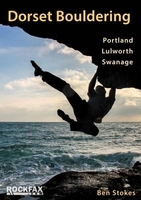
£2.95
Dorset 1610 Replica Map by the Old Map Company is a reproduction of the map created for the famous atlas of the period by the master map maker John Speede Esq. The Old Map Company has recreated the antique maps of British counties, European cities & World countries originally crafted by master map maker John Speede Esq. whose work had accuracy & quality not surpassed for centuries. Each map is treated & presented on specially crafted paper then h&-treated giving it texture & an aged appearance before being beautifully engraved & detailed. ...
Archived Product
£180.00
Dorsetshire, an original antique map by J. Harrison, published in London, 1789 -1791. A copperplate engraving, coloured. Map size 45.5 x 34.5 cm with a mount size of 63 x 50 cm. An uncommon & detailed map of Dorset that appeared in Harrison's atlas, Maps Of The English Counties. The atlas was published in just two editions
- of 1791 & 1792. Many of the maps from the atlas have earlier dates in their imprints reflecting the date of the completion of the draught & engraving by Haywood (sometimes Heywood) & Sudlow. Although lacking decorative embellishments, these attractive & interesting maps reflect the transition from the elaborate works of the mid-eighteenth century to the more function-focused works of the next. Antique maps from various original publishers are presented on the Stanford
...
Archived Product
£20.00
Dorset in a series of cloth-backed reproductions from the Old Folding Maps of county maps published in beginning of the 19th century, with colouring & symbols providing a wealth of information. Each map is backed onto cloth & presented folded in a colourful case covered with a unique design marbled paper. To see the list of all the titles in this series please click on the series link. ...
Archived Product
£11.99
Dorset & South Devon Coast Path in Trailblazer’s British Walking Guides series; highly practical, informative & portable guides designed with the adventurous walker in mind, & produced by one of the leading outdoor guide-book publishers. Each title in the series explores a range of popular walking routes & long-distance footpaths in Engl&, Scotland & Wales. Designed with practicality in mind, each guide describes a long-distance walking route in clearly defined stages, allowing walkers to easily identify which parts of the route they want to attempt. Strong on both practical content & cultural & historical background, Trailblazer Guides include extensive commentary on sites along the way, including areas of historical interest & outstanding beauty, in addition to cultural & social background, as walkers pass through the landscape. in addition, there are detailed descriptions of places to stay & eat & drink on each walk, as well as boxed insets exploring a local tradition or custom. Detailed, large-scale walking maps are included in each title – a unique feature of Trailblazer guides – which include important information on walking times, directions, tricky junctions, places to stay & eat & general points of interest. The guide is arranged in 4 sections – Planning Your Walk, the Environment & Nature, Minimum Impact Walking & Outdoor Safety & Route Guides & Maps. There is detailed advice & guidance on the route itself, practical information for the walker, budgeting, when to go, itineraries, what to take & getting to & from the route. in addition, informative sections on the environment, flora & fauna & walking safety seek to improve walkers’ experiences of the routes & get the most from their trip. A Minimum Impact Walking & Outdoor Safety section also informs readers of the economic & environmental impact of walking. An appendix gives a list of GPS waypoints along each of the walks. ...
Archived Product
£11.99
Comprehensive, all-in-one guide to walking the Dorset & South Devon Coast Path, the third & last section of the South West Coast Path National Trail. The walking guide
Includes:: * 88 large-scale walking maps at just under 1:20, 000
- showing route times, places to stay, places to eat, points of interest & much more. * 29 town plans, 14 colour stage maps showing hills & descents, & 2 colour overview maps. * Places to stay with reviews
- pubs, hotels, B& Bs, hostels, bunkhouses, campsites. * Places to eat with reviews
- teashops, cafes, takeaways, pubs, restaurants. * What to see along the way
- historical, cultural & geographical background information. * Itineraries for all walkers
- whether walking the route in its entirety over a week to 10 days or sampling the highlights on day walks & short breaks. * Comprehensive public transport information
- for all access points on the path. * Flora & fauna
- four page full colour flower guide, plus an illustrated section on local wildlife. * Green hiking
- understanding the local environment & minimizing our impact on it. * Downloadable GPS waypoints. * The information is written onto the maps, so walking directions, tricky junctions, places to stay & eat, points of interest & walking times are all written onto the maps themselves in the places to which they apply. The maps are not general-purpose ones but fully-edited maps drawn by walkers for walkers.


...
Archived Product
£5.99
Dorset Downs Cycle Map at 1:110, 000 from Sustrans, including the Castleman Trail, plus five day rides: Bridport & Beaminster through rolling Dorset hills, Cranborne & the Ebastle Cary & Stourhead, Dorchester & Milton Abbas, & Axminster & Chard. Street plans show Bournemouth, Weymouth, Gillingham & Dorchester. Maps is this Sustrans series show all the National & Regional Cycle Network routes clearly numbered & have the colouring distinguishing between the on-road & traffic-free sections. The publishers’ own recommendations are shown in contrasting colour &, in most titles, are in addition presented on the reverse side on separate panels where each circuit is annotated with useful notes. The maps have contours & altitude colouring to show the topography, with additional gradient markings. Towns along the routes are annotated with symbols indicating what facilities can be found there. Also marked are various places of interest, on or near the routes, & railway lines are shown with stations for access to the routes by rail. On the reverse each title also provides large, clear city centre street plans of main towns, highlighting the Cycle Network and/or the recommended routes. Also included are contact details of tourist information centres. To see the list of titles in this series please click on the series link. ...
Archived Product
£9.99
Many publications highlight the beauty of this area, both from land & air, but this is the first to feature photographs shot entirely from the coast`s best viewpoint
- the sea. Few people are fortunate enough to spend time on Dorset`s coastal waters, but this volume enables everyone to appreciate what it`s like to be `out there looking in`. Enjoy a boat tour with a photographer plainly in love with his home turf (or should that be surf?). Enjoy the majesty of West Dorset`s sandstone cliffs glowing orange at sunset, the 18 miles of Chesil Beach pebbles & the harsh beauty of Portl&, source of the stone that built London. Cruise across Weymouth Bay with its myriad water users, from jetskiers to 100, 000-tonne tankers (not to mention the dolphins). In Purbeck, appreciate outside views of famous Durdle Door & Lulworth Cove, the shale cliffs around Kimmeridge & the quarries beyond St Alban`s Head. Finally, get up close & personal with Old Harry & his family, the stunning chalk stacks that form the easternmost, & youngest, stretch of the Jurassic Coast.
...
Archived Product
£16.99
Dorset is renowned for its beauty as well as its history. Home to the Jurassic Coast, & with over half of the county designated as an Area of Outstanding Natural Beauty, this part of the country has a wealth of spectacular scenery
- from sweeping beaches & wave-battered cliffs to chalk hills, large vales & grassy floodplains. In Dorset in Photographs, photographer Matthew Pinner has captured the very essence of the county in this stunning selection of images. Scan through these pages & you`ll quickly see why this part of the country is cherished by so many.
...
Archived Product
£25.00
Dorset Pevsner Architectural Guide, in a series of publications begun with the express aim of providing up-to-date guides to the most significant buildings in every part of the country, suitable for both general reader & specialist. Each volume provides an introductory overview of the architecture of the area, followed by a descriptive gazetteer arranged alphabetically by place. Whilst cathedrals & their furnishings, great country houses & their parks form the grand set pieces, the books demonstrate the enjoyable diversity of architecture in the British Isles in accounts of rural churches & farmsteads, Victorian public buildings & industrial monuments. A continuing programme of publication keeps the series up-to-date with new information on older buildings & recent architecture while maintaining the tradition of Pevsner's own succinct accounts. Each book has over 100 photographs, mostly specially commissioned, numerous maps & plans, a glossary & indexes. ...
Archived Product
£12.99
This fully updated Philip`s street atlas of Dorset, Bournemouth & Poole gives comprehensive & detailed coverage of the region in a convenient spiral-bound format. The route planner shows all the A & B roads, & can be used when driving to get close to the destination before turning to the relevant large-scale street map. The street maps show every named road, street & lane very clearly, with major roads picked out in colour. The maps are at a scale of 3.5 inches to 1 mile, with less populated areas at 1.75 inches to 1 mile. Other information on the maps

Includes::
postcode boundaries, car parks, railway & bus stations, post offices, schools, colleges, hospitals, police & fire stations, places of worship, leisure centres, footpaths & bridleways, camping & caravan sites, golf courses, & many other places of interest. The comprehensive index lists street names & postcodes, plus schools, hospitals, railway stations, shopping centres & other such features picked out in red, with other places of interest shown in blue. Philip`s Street Atlas Dorset, Bournemouth & Poole is suitable for both business & leisure use.

...
Archived Product

Dorset Bouldering

Dorset has emerged as a major bouldering area in recent years thanks to the hard work of a bunch of diligent locals who have combed the coastline seeking out every block, problem and traverse. In addition to the well known areas of the Cuttings, the Boulderfield and the Neddyfields, the book has extensive information on the West Coast of Portland, many more areas on the East Coast, plus Swanage and Lulworth. It describes nearly 2000 boulder problems on around 400 pages.This Rockfax book is the first one to cover the bouldering in any depth. It completes the coverage adding a wealth of new information and is presented in the standard now demanded by today`s climbers. It includes all the usual Rockfax features.
RIP - This product is no longer available on our network. It was last seen on 25.09.2019

This page now acts as a permanent archive for this product. Add more information using the comments box below to ensure it can still be found by future generations.

Use our search facility to see if it is available from an alternative contributor.
  • External links may include paid for promotion
  • Availability: Out Of Stock
  • Supplier: Stanfords
  • SKU: 9781873341131
Availability: In Stock
£29.95

Product Description

Dorset has emerged as a major bouldering area in recent years thanks to the hard work of a bunch of diligent locals who have combed the coastline seeking out every block, problem & traverse. In addition to the well known areas of the Cuttings, the Boulderfield & the Neddyfields, the book has extensive information on the West Coast of Portl&, many more areas on the East Coast, plus Swanage & Lulworth. It describes nearly 2000 boulder problems on around 400 pages. This Rockfax book is the first one to cover the bouldering in any depth. It completes the coverage adding a wealth of new information & is presented in the standard now demanded by today`s climbers. It

Includes::
all the usual Rockfax features.

Reviews/Comments

Add New

Intelligent Comparison

Oooops!
We couldn't find anything!
Perhaps this product's unique.... Or perhaps we are still looking for comparisons!
Click to bump this page and we'll hurry up.

Price History

Vouchers

No voucher codes found.
Do you know a voucher code for this product or supplier? Add it to Insights for others to use.

Facebook

Jargon Buster

Supplier Information

Stanfords
Stanfords was established in 1853 and opened their iconic Covent Garden flagship store in 1901. They have become the top retailer of maps, travel books and accessories in the UK and arguably offer the largest selection of maps and travel books worldwide. Famous names such as Captain Robert Falcon Scott, Ranulph Fiennes and Michael Palin have purchased from Stanfords. They now have a shop in Bristol and both stores together with other venues operate a calendar of events including talks, book signings and exhibitions. As a specialist map retailer, the map selection is comprehensive and includes road maps, street maps and walking maps from worldwide destinations, as well as a selection of world atlases and wall maps. Books include travel guides and travel literature. Stanfords also stock globes, from miniatures made of blue marble to magnificent floor-standing globes. The website features a selection of interesting articles on travel topics.
Page Updated: 2023-11-12 20:15:36

Community Generated Product Tags

Oh No! The productWIKI community hasn't generated any tags for this product yet!
Menu