More From Contributor
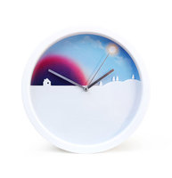
£2.95
Dawley Magna & Strichley in 1901 in a fascinating series of reproductions of old Ordnance Survey plans in the Alan Godfrey Editions, ideal for anyone interested in the history of their neighbourhood or family. Selected towns in Great Britain & Ireland are covered by maps showing the extent of urban development in the last decades of the 19th & early 20th century. In this title: the map covers the area from New Street & New Road through to Lower Brands in Stirchley. Features include Holy Trinity Church, Lord Inn Hotel, Dawley Castle (site of), Town Hall, Mission Church & White Hart Inn, Stirchley Iron Works, Grange Farm, St James's Church, Stirchley Hall Farm & the Railway Line & Station. On the reverse are an extract from a commercial directory & a list of private residents for Dawley. About the Alan Godfrey Editions of the 25 ...
Archived Product
£30.00
The world`s best landscape photography & photojournalism stunningly depicts the passage of a single day, from dawn`s first light to the closing moments of sunset. Experience shimmering mornings & opaque nights through the eyes of our finest photographers in this gloriously uplifting volume
- the latest entry in National Geographic`s best-selling annual photography collection. Daybreak whispers mauve over a long ocean horizon. The morning sun twinkles in a drop of dew. The broad heat of midday radiates over a beach strewn with sweat-baked sunbathers. A slender crescent moon caresses a gnarled tree standing alone on the heath. Full of one-of-a-kind photographs, this breathtaking collection gives readers a front-row seat to the world`s wonders, from its most imposing cityscapes to its most pristine landscapes. Selected from the portfolios of the most celebrated photographers, the images in this book are strikingly arranged to depict the beauty & majesty of light in all its variations. Short legends accompany every photograph to explain the picture, the scene it conveys, or how the shot was captured, along with inspiring"ations from literature. With the widest possible array of perspectives, close-ups, & details, these photos present a new experience of time & light. Large-format pages & a simple, striking design play up the photographs as they dem&. Chapters dedicated to each phase of the day show distinctly different yet harmonizing visions, with unique insight & perspective from photographers, confirming that around the world & throughout all time, the passage of light from dawn to dusk, from morning to night & back again, connects us all.
...
Archived Product
£6.99
Street plan of Dax, part of an extensive series covering French cities & towns from Blay-Foldex, the country’s largest, oldest & most experienced publisher of urban mapping. Blay plans include outer suburbs &, where appropriate, adjoining localities forming part of the urban agglomeration & provide brief descriptions of the town’s main sights, contact details for hotels & other places of interest, etc. The plans show one way streets, car parks & pedestrian zones. Important public buildings are clearly marked & identified. Blay street maps are usually double-sided & include an enlargement for the town centre & a street index with separate lists of “edifices publics”: main public buildings, places of worship, schools, sport facilities, stations, etc. Each of the outer suburbs or the adjoining localities, identified with its postcode, has a separate index. Many titles also provide a road map of the environs. All the text is in French only.PLEASE NOTE: to see the list of Blay-Foldex street plans of French towns & cities please click on the series link – the series description also

Includes::
a comparison between Blay & IGN street plans.

...
Archived Product
£12.99
Topographic survey of France at 1:25, 000 in IGN`s excellent TOP25 / Série Bleue series. All the maps are GPS compatible, with a 1km UTM grid plus latitude & longitude lines at 5’ intervals. Contours are at 5m intervals except for mountainous areas where the maps have contours at 10m intervals, vividly enhanced by hill shading & graphics for rocky terrain. Colouring with graphics indicates different types of vegetation or land use (deciduous or coniferous forests, moors, orchards, vineyards, etc). PLEASE NOTE: coverage of France at this scale is currently being revised – the format & the presentation of each title are indicated by the letters at the end of its Sheet Reference number (e.g. 0416ET, 3531ETR, 1923SB, etc.)MAPS WITH FULL TOURIST OVERPRINT & AN ENGLISH MAP LEGEND: all TOP25 maps & the SB editions of Série Bleue have an overprint highlighting waymarked walking trails including long-distance GR routes &, where appropriate, ski routes. Symbols indicate campsites, gîtes d’etape, refuges, equestrian centres & other recreational facilities or sites, tourist information centres, cultural heritage, etc. Towns & locations of particular interest are highlighted.- ET or OT = single-sided TOP25 map covering approx. 29x 21 km / 18x 13 miles.- ETR or OTR = waterproof & tear resistant TOP25 map covering the same area as the corresponding ET or OT number, but double-sided, printed on a smaller size sheet with a good overlap between the sides.- SB = Série Bleue map with full tourist overprint; these maps, first introduced in summer 2014, each cover approx. 29x 24km / 18x 15 miles.SÉRIE BLEUE maps with numbers ending in E (Est) or O (Ouest): most editions now indicate the GR routes, but do not show any other tourist information. Map legend is in French only. Each map covers approx. 14x 20km / 9x 12 miles. ...
Archived Product
£12.00
The Day & Night Mug is a heat sensitive colour changing mug. With the use of heat sensitive technology & detailed satellite imagery, you can watch the world turn from night to day while having your morning brew. Simply add hot liquid to activate the transformation. When the hot drink warms the mug, the world map slowly brightens into view, revealing accurate topography & a real-life representation of what the earth looks like from outer space. As the liquid cools, darkness descends again & the map slowly fades out, uncovering pin-pricks of light where the world`s major cities are. ...
Archived Product
£11.99
A celebration of the pleasures of daytime drinking
- whether by the pool, in a hammock, or snuggled up by the fire
- that

...
Archived Product
£19.99
Day Drives from Cape Town map is the most comprehensive map available of the heartland of the Western Cape. The map shows all the roads, towns & relief of the area from Cape Town north to Citrusdal, north-east to Laingsburg & east to Stilbaai / Albertinia: all destinations within easy motoring reach of Cape Town. The most important tourist features are included, with `smiling faces` indicating the most scenic routes. This is the third edition of this popular general guide, now extended eastwards to make it even more useful than before! One side of this double-sided map covers the area from Cape Town, up the west coast to Velddrif & across via Aurira & Piketberg to Citrusdal & the Kouebokkeveld. Ceres, Worcester, Stanford & Gansbaai mark the eastern edge of Side 1, which also

Includes::
a useful enlargement of the Cape Peninsula, at a scale of 1:200 000. Turn over the map [there is a small, useful overlap] & the map will take you via Touwsrivier to Laingsburg & the southern Tankwa. Travel south via Calitzdorp, Ladismith & Riversdale to Stilbaai, & then west back to Cape Agulhas, Napier, Mc Gregor & Robertson – with all the great destinations in between. All roads (tar & gravel) are shown with accurate mileages between major junctions. Full GPS details are shown at every major road-junction in DDMMSS format. Particularly scenic routes are marked with smiley faces Major mountain biking, horse riding, nature reserves, river rafting, golf & hiking facilities, farm stalls, historic sites & many other attractions are carefully plotted. Tourism information & all kinds of accommodation from out-of-town lodges to back packers & campsites are shown.

...
Archived Product
£20.00
We didn`t know where it was all going. We just didn`t know. One day in 1968 Don Mc Cullin, then regarded as the world`s most accomplished war photographer, received a commission from the Apple Corporation to spend a day photographing the Beatles. Mc Cullin had just returned from covering the bitter fighting during the Tet Offensive in Vietnam, & was the most hardened photojournalist in the field. He was astonished by the invitation. On Sunday 28 September he met the Beatles at the Sunday Times studio & began to photograph them in colour for a Life magazine cover. The day that followed has become known in Beatles lore as ` The Mad Day Out`. Mc Cullin shot twenty rolls of black-&-white film in various locations across London, from the banks of the Thames to Paul Mc Cartney`s garden. Apart from the cover photograph & two pictures in Mc Cullin`s recent book In Engl&, we believe the work to be otherwise unpublished. The timing of this day was significant. At the height of their international fame following the release of Sgt. Pepper`s Lonely Hearts Club B&, the Beatles were in the middle of recording the White Album. The war was raging in Vietnam & riots had spread through capital cities worldwide. It was the very moment of a generational divide, & the Beatles were the iconic figureheads of the youth movement. One of the most poignant photographs taken that day was of John Lennon posing as dead, surrounded by the other three, in an image that he himself had carefully choreographed. What was an intentional pose in protest is now seen as tragic & prophetic. These pictures are of four inspired musicians on the cusp of the change. They mark the passing of an era in which we can glimpse our own lost youth. ...
Archived Product
£9.99
The Mexican celebration to remember loved ones is a whirlwind of patterns
- the iconic sugar skulls, the beautiful marigolds,
...
Archived Product

Day And Night Clock

Wall clock with a rotating backdrop.Hang this unique clock on the wall and enjoy the view from dusk `til dawn. The skyline gradually rotates as the hands move, so what you see on the face always matches the daylight outside. Spans a full 24 hours.The perfect gift for clock watchers.
RIP - This product is no longer available on our network. It was last seen on 25.09.2019

This page now acts as a permanent archive for this product. Add more information using the comments box below to ensure it can still be found by future generations.

Use our search facility to see if it is available from an alternative contributor.
  • External links may include paid for promotion
  • Availability: Out Of Stock
  • Supplier: Stanfords
  • SKU: 5060043067472
Availability: In Stock
£29.99

Product Description

Wall clock with a rotating backdrop. Hang this unique clock on the wall & enjoy the view from dusk `til dawn. The skyline gradually rotates as the hands move, so what you see on the face always matches the daylight outside. Spans a full 24 hours. The perfect gift for clock watchers.

Reviews/Comments

Add New

Intelligent Comparison

Oooops!
We couldn't find anything!
Perhaps this product's unique.... Or perhaps we are still looking for comparisons!
Click to bump this page and we'll hurry up.

Price History

Vouchers

No voucher codes found.
Do you know a voucher code for this product or supplier? Add it to Insights for others to use.

Facebook

Jargon Buster

Clock - A device used for telling the time
Wall - A physical barrier between two areas
Gift - Something that is presented without expecting anything in return
Day - The time it takes a planet or other space objects to complete one rotation.
Rotates - Something that can move around and axis or in a circle.

Supplier Information

Stanfords
Stanfords was established in 1853 and opened their iconic Covent Garden flagship store in 1901. They have become the top retailer of maps, travel books and accessories in the UK and arguably offer the largest selection of maps and travel books worldwide. Famous names such as Captain Robert Falcon Scott, Ranulph Fiennes and Michael Palin have purchased from Stanfords. They now have a shop in Bristol and both stores together with other venues operate a calendar of events including talks, book signings and exhibitions. As a specialist map retailer, the map selection is comprehensive and includes road maps, street maps and walking maps from worldwide destinations, as well as a selection of world atlases and wall maps. Books include travel guides and travel literature. Stanfords also stock globes, from miniatures made of blue marble to magnificent floor-standing globes. The website features a selection of interesting articles on travel topics.
Page Updated: 2023-11-12 20:15:36

Community Generated Product Tags

Oh No! The productWIKI community hasn't generated any tags for this product yet!
Menu