
 United Kingdom
 France
 Germany
 Netherlands
 Sweden
 USA
USA
 Italy
Italy
 Spain
Spain
More From Contributor


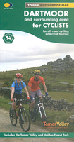
Dartmoor For Cyclists
Dartmoor on a double-sided, light, waterproof and tear-resistant map providing on one side a map at 1:60, 000 covering a wider area between Exeter and Plymouth, with on the reverse the Dartmoor National Park at 1:40, 000 with highlighting for off-road cycle trails.On one side a map at 1:60, 000 covers the area between Exeter and Plymouth. The map has contours with altitude colouring, plus colours/graphics to indicate open moorland, woodland and dense plantations. An overprint indicates roads within the National Cycle Network, as well as recommended cycle routes on minor and main roads. Also marked are off-road cycle routes, graded into easy, moderate, difficult and severe. Symbols indicate various local facilities and places of interest.On the reverse a more detailed map at 1:40,
000 covers Dartmoor National Park. The map has contours at 15m intervals, plus colouring for farmland or pastures, fell or moorland, woodland, etc. Numerous off-road routes are prominently highlighted, with their colouring clearly indicating the degree of difficulty. Separate panels provide similar detailed coverage of two areas outside the national park: Tamaar Valley at 1:40, 000 and Haldon Forest at 1:25, 000. All the mapping has the lines of the British National Grid. The map also includes information on public transport within the region, advice and tips on safety, etc.To see the other titles in this series please click on the series link.
000 covers Dartmoor National Park. The map has contours at 15m intervals, plus colouring for farmland or pastures, fell or moorland, woodland, etc. Numerous off-road routes are prominently highlighted, with their colouring clearly indicating the degree of difficulty. Separate panels provide similar detailed coverage of two areas outside the national park: Tamaar Valley at 1:40, 000 and Haldon Forest at 1:25, 000. All the mapping has the lines of the British National Grid. The map also includes information on public transport within the region, advice and tips on safety, etc.To see the other titles in this series please click on the series link.

Product Description
Reviews/Comments
Add New
Vouchers
No voucher codes found.
Do you know a voucher code for this product or supplier? Add it to Insights for others to use.
Do you know a voucher code for this product or supplier? Add it to Insights for others to use.
 Denmark