
 United Kingdom
 France
 Germany
 Netherlands
 Sweden
 USA
USA
 Italy
Italy
 Spain
Spain
More From Contributor


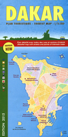
Dakar
Dakar on an indexed street plan at 1:16, 000 from Laure Kane Editions, with an enlargement for its central Plateau district. Coverage includes the city’s international Leopold Sedar Senghor airport and Ile de Gorée. Bright colours indicate Dakar’s administrative districts. A wide range of symbols shows hotels, markets, public beaches and surfing areas, as well as various public buildings and facilities. Outside the central area only main streets are named and listed in an index which also includes hotels and restaurants, markets, cultural centres, various administrative offices, etc. Map legend is in English and French.An enlargement shows Dakar’s central Plateau district in greater detail and clarity.

Product Description
Reviews/Comments
Add New
Vouchers
No voucher codes found.
Do you know a voucher code for this product or supplier? Add it to Insights for others to use.
Do you know a voucher code for this product or supplier? Add it to Insights for others to use.
 Denmark