More From Contributor

£11.50
Topographic survey of France at 1:25, 000 in IGN`s excellent TOP25 / Série Bleue series. All the maps are GPS compatible, with a 1km UTM grid plus latitude & longitude lines at 5’ intervals. Contours are at 5m intervals except for mountainous areas where the maps have contours at 10m intervals, vividly enhanced by hill shading & graphics for rocky terrain. Colouring with graphics indicates different types of vegetation or land use (deciduous or coniferous forests, moors, orchards, vineyards, etc). PLEASE NOTE: coverage of France at this scale is currently being revised – the format & the presentation of each title are indicated by the letters at the end of its Sheet Reference number (e.g. 0416ET, 3531ETR, 1923SB, etc.)MAPS WITH FULL TOURIST OVERPRINT & AN ENGLISH MAP LEGEND: all TOP25 maps & the SB editions of Série Bleue have an overprint highlighting waymarked walking trails including long-distance GR routes &, where appropriate, ski routes. Symbols indicate campsites, gîtes d’etape, refuges, equestrian centres & other recreational facilities or sites, tourist information centres, cultural heritage, etc. Towns & locations of particular interest are highlighted.- ET or OT = single-sided TOP25 map covering approx. 29x 21 km / 18x 13 miles.- ETR or OTR = waterproof & tear resistant TOP25 map covering the same area as the corresponding ET or OT number, but double-sided, printed on a smaller size sheet with a good overlap between the sides.- SB = Série Bleue map with full tourist overprint; these maps, first introduced in summer 2014, each cover approx. 29x 24km / 18x 15 miles.SÉRIE BLEUE maps with numbers ending in E (Est) or O (Ouest): most editions now indicate the GR routes, but do not show any other tourist information. Map legend is in French only. Each map covers approx. 14x 20km / 9x 12 miles. ...
Archived Product
£12.99
When Shagun leaves Raman for another man, a bitter legal battle ensues. The custody of their two young children is thrown into question & Shagun must decide what price she will pay for freedom... Meanwhile, Ishita, a failed marriage behind her, finds another chance at happiness with Raman. But when the courts threaten the security of her new family, she decides to fight for it
- whatever the cost. From prize-winning author Manju Kapur, Custody is an intimate portrait of marriages that disintegrate & intertwine, with heart-rending consequences.
...
Archived Product
£7.99
When Shagun leaves Raman for another man, a bitter legal battle ensues. The custody of their two young children is thrown into question & Shagun must decide what price she will pay for freedom... Meanwhile, Ishita, a failed marriage behind her, finds another chance at happiness with Raman. But when the courts threaten the security of her new family, she decides to fight for it
- whatever the cost. From prize-winning author Manju Kapur, ” Custody” is an intimate portrait of marriages that disintegrate & intertwine, with heart-rending consequences.
...
Archived Product
£25.00
Cycling has never lost its appeal. Alongside mass-produced models, the craftsmanship of bespoke bicycle makers has emerged to satisfy the passion of people who ride bikes as a means of daily transport, as a sport & for recreation. This book by passionate cyclists Christine Elliott & David Jablonka is the product of a worldwide search for the most influential custom bicycle makers on the planet. The result is a presentation of a wonderful collection of expertly honed, human-powered machines, built by some of the most creative bicycle makers in the world. It highlights the range of techniques, materials, design elements, & dedication that go into producing a custom handmade bicycle. It is guaranteed to take you on the ride of your life. ...
Archived Product
£3.50
Custom House & Plaistow Marshes in 1867 in a fascinating series of reproductions of old Ordnance Survey plans in the Alan Godfrey Editions, ideal for anyone interested in the history of their neighbourhood or family. Three versions of this map cover the same area, stretching from St Luke`s Square & Forty Acre Lane eastward to Leyes Road & beyond, & from Wanlip Road southward to Victoria Dock Road which runs along the lower portion of the map, including the northern tip of Royal Victoria Dock. The western half of the map is built up with the eastern part of Canning Town; by contrast the map is largely empty undeveloped east of Prince Regents Lane. Features include Plaistow Marsh, GER Woolwich Branch including Custom House station, Hudsons Ward, Tidal Basin Ward, Custom House Sports Ground, tramways. Streets include Beckton Road, Denmark Street, Freemasons Road, etc. All the maps include directory extracts. The 1867 map shows the area at a very early stage of development, with scarcely a sign of Canning Town`s movement eastwards. The Victoria Dock has been built & Tidal Basin & Custom House stations are open, but to the north & east of them is marshl&. About the Alan Godfrey Editions of the 25” OS Series: Selected towns in Great Britain & Ireland are covered by maps showing the extent of urban development in the last decades of the 19th & early 20th century. The plans have been taken from the Ordnance Survey mapping & reprinted at about 15 inches to one mile (1:4, 340). On the reverse most maps have historical notes & many also include extracts from contemporary directories. Most maps cover about one mile (1.6kms) north/south, one & a half miles (2.4kms) across; adjoining sheets can be combined to provide wider coverage.FOR MORE INFORMATION & A COMPLETE LIST OF ALL AVAILABLE TITLES PLEASE CLICK ON THE SERIES LINK. ...
Archived Product
£9.99
Create beautiful, layered paper dioramas with this clever art activity book. With a combination of drawing, colouring & craft skills, children are taken page-by-page through creating four seasonal landscape scenes. The front of the pages contain line illustrations, created by Anouck Boisrobert, to which children can colour in & add detail. On turning the page to view the reverse side, cut lines will become visible, with instructions on which area of the page to cut away. As each page is finished in turn, a layered landscape is slowly created. Flipping back to the first page will reveal the completed seasonal scene in all its glory! The activities will help children develop scissor skills, as well as offering a magical new twist on colouring books. ...
Archived Product
£8.99
This delightful activity book contains four press-out dolls & lots of mix-&-match clothes, shoes & accessories to dress them for rainy days, summer holidays, a fairytale ball & much more. There are also outlines of clothes that children can draw on to design outfits of their own. ...
Archived Product
£9.99
This is a book to make your own. Embrace your style & use pattern, colour & shape to reflect your personal taste. Become the designer of your world as you create inspired ideas of your own. Collage, design & play, cut, paste & create. Cut, Paste, Create is a visual journal where the reader is encouraged to fill the pages with design ideas using collage & to explore & reflect on their own creative concepts & personal taste. Whilst some pages seek a more personal engagement, for example relating to moods or feelings, others simply provide a space to ` design a range of coats for your dog` or ` create a welcome mat` to invite people in to your home. Including helpful tips & basic principles of collage, the reader is guided to source materials from their everyday world & to look for what is beautiful, inspiring or unusual to them. * If you could change your hairstyle every day, what would it look like? * Collage designs for your own fashion collection * Create your own wallpaper * Design your own bookends * Collage some cheery umbrella designs for when you` re under the weather * Create your own set of stamps * Design a range of eyewear to suit your mood ...
Archived Product
£13.99
” Cats of Instagram” meets National Geographic in this hilarious picture book about nature`s cutest weirdos from the author of Pink Is for Blobfish! The Internet pretty much runs on cute animal photos, but ”cute” is so much more than clickbait kittens & insta-pups. Cute is for feathery-gilled axolotls (pronounced: ax-uh-LOT-ulz), shy pygmy hippos, poisonous blue dragons, & armored pangolins. All of these animals are cute, but they`ve also adapted remarkable ways to survive in their unique environments. With her signature blend of humor & zoological know-how, Pink Is for Blobfish author Jess Keating shows how cute animals can be more than just a pretty face in this latest installment of the World of Weird Animals. ...
Archived Product
£29.95
One of the maps in the topographic survey of Peru from the country’s national survey organization, Instituto Geográfico Nacional. Contours are at 25m intervals & colouring/symbols indicate different types of terrain & vegetation. Some of the maps may contain small blank spaces representing as yet unmapped areas. Each sheet covers 30’ latitude by 30’ longitude. The maps have a 1km UTM grid & margin ticks for latitude & longitude at intervals of 1’. Publication dates vary; most maps were published in 1960s to 1990s, with some sheets revised more recently. Map legend is in Spanish only, except in the more recent editions which also include English. ...
Archived Product

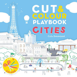
Cut & Colour Playbook Cities

Grab your scissors and some pencils or crayons and get ready to make some beautiful cityscapes with Cut & Colour Playbook: Cities! Featuring four different cities, children combine drawing, colouring, and scissor skills to create their scenes. First, colour in line illustration and add your own details. Then, on the reverse of the page, follow the cut lines to snip away parts of the page. By the end of the process, you will have built up your very own city scene by layering up the pages. At the end of the book, an additional section gives children the chance to create their own layered diorama, whether a city scene or beyond. An original twist on the colouring book format, Cut and Colour Playbook: Cities encourages children to develop arts and crafts skills, and to think through
a multi-layered project in a fun and creative way.
RIP - This product is no longer available on our network. It was last seen on 25.09.2019

This page now acts as a permanent archive for this product. Add more information using the comments box below to ensure it can still be found by future generations.

Use our search facility to see if it is available from an alternative contributor.
  • External links may include paid for promotion
  • Availability: Out Of Stock
  • Supplier: Stanfords
  • SKU: 9781782404019
Availability: In Stock
£9.99

Product Description

Grab your scissors & some pencils or crayons & get ready to make some beautiful cityscapes with Cut & Colour Playbook: Cities! Featuring four different cities, children combine drawing, colouring, & scissor skills to create their scenes. First, colour in line illustration & add your own details. Then, on the reverse of the page, follow the cut lines to snip away parts of the page. By the end of the process, you will have built up your very own city scene by layering up the pages. At the end of the book, an additional section gives children the chance to create their own layered diorama, whether a city scene or beyond. An original twist on the colouring book format, Cut & Colour Playbook: Cities encourages children to develop arts & crafts skills, & to think through a multi-layered project in a fun & creative way.

Reviews/Comments

Add New

Intelligent Comparison

Oooops!
We couldn't find anything!
Perhaps this product's unique.... Or perhaps we are still looking for comparisons!
Click to bump this page and we'll hurry up.

Price History

Vouchers

No voucher codes found.
Do you know a voucher code for this product or supplier? Add it to Insights for others to use.

Facebook

Jargon Buster

Scissors - A hand operated cutting instrument mainly for paper and textiles
Fun - Something that provides amusement or enterainment
Colour - The categorised spectrum of light visable to humans
Children - A young life form within the early stages of physical development,

Supplier Information

Stanfords
Stanfords was established in 1853 and opened their iconic Covent Garden flagship store in 1901. They have become the top retailer of maps, travel books and accessories in the UK and arguably offer the largest selection of maps and travel books worldwide. Famous names such as Captain Robert Falcon Scott, Ranulph Fiennes and Michael Palin have purchased from Stanfords. They now have a shop in Bristol and both stores together with other venues operate a calendar of events including talks, book signings and exhibitions. As a specialist map retailer, the map selection is comprehensive and includes road maps, street maps and walking maps from worldwide destinations, as well as a selection of world atlases and wall maps. Books include travel guides and travel literature. Stanfords also stock globes, from miniatures made of blue marble to magnificent floor-standing globes. The website features a selection of interesting articles on travel topics.
Page Updated: 2023-11-12 20:15:36

Community Generated Product Tags

Oh No! The productWIKI community hasn't generated any tags for this product yet!
Menu