
 United Kingdom
 France
 Germany
 Netherlands
 Sweden
 USA
USA
 Italy
Italy
 Spain
Spain
More From Contributor


Cuba Gizi Map
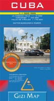
Cuba with excellent topographic information on an indexed map from Gizi, with a street plan of central Havana, enlargements for the Varadero Peninsula, Valle de Viñales and the environs of the capital, plus a distance table.Vivid altitude colouring with graphics for mangrove and swamps, plus plenty of names of geographical features: peaks, mountain ranges, national parks and protected areas, etc., show the terrain. In coastal waters coral reefs are marked and sea depths are given. Road network gives distances on main and secondary routes and includes dirt tracks. Railways and local airfields are marked, as well as provincial administrative boundaries. Symbols highlight various places of interest including world heritage sites, locations with tourist accommodation, campsites,
beaches, diving and fishing sites, marinas, etc. The map has latitude and longitude lines at intervals of 1º and an extensive index of localities. Map legend included English.Enlargements cover the Varadero Peninsula (1:50, 000) with names of numerous hotels and places of interest and Valle de Viñales (1:75, 000) with hiking trails. Also included is a street plan of Old Havana, annotated with places of interest, a map of greater Havana showing main access roads, districts and places of interest outside the city centre, plus a distance table.
beaches, diving and fishing sites, marinas, etc. The map has latitude and longitude lines at intervals of 1º and an extensive index of localities. Map legend included English.Enlargements cover the Varadero Peninsula (1:50, 000) with names of numerous hotels and places of interest and Valle de Viñales (1:75, 000) with hiking trails. Also included is a street plan of Old Havana, annotated with places of interest, a map of greater Havana showing main access roads, districts and places of interest outside the city centre, plus a distance table.

Product Description
Reviews/Comments
Add New
Vouchers
No voucher codes found.
Do you know a voucher code for this product or supplier? Add it to Insights for others to use.
Do you know a voucher code for this product or supplier? Add it to Insights for others to use.
 Denmark