
 United Kingdom
 France
 Germany
 Netherlands
 Sweden
 USA
USA
 Italy
Italy
 Spain
Spain
More From Contributor


Crete Borch
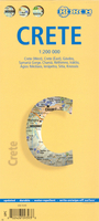
Crete at 1:200, 000 on a laminated, waterproof tourist map from Borch, with street plans of central Iraklion, Rethymnon, Chania, Agia Nikolaos, Ierapetra, and Sitia, and enlargement of the Gorge of Samaria, plus a plan of Knossos. The map divides the island east/west with a good overlap between the sides. Bold relief shading with spot heights and names of mountain chains shows the topography. Road network includes minor roads and selected local tracks and give driving distances on main routes. Symbols highlight places of interest, including numerous beaches, archaeological sites, etc. The map is index and has no geographical coordinates.The map includes indexed street plans of the island’s main towns, also annotated with sights and various facilities. An enlargement shows
the Gorge of Samaria and the nearby coast in greater detail at 1:90, 000. Also included are plans of the archaeological site at Knossos and a month-by-month climate chart.
the Gorge of Samaria and the nearby coast in greater detail at 1:90, 000. Also included are plans of the archaeological site at Knossos and a month-by-month climate chart.

Product Description
Reviews/Comments
Add New
Intelligent Comparison
Archived Product
Seattle Borch Stanfords
£8.99
Archived Product
Chile Borch Stanfords
£9.99
Archived Product
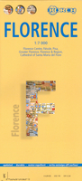
Florence Borch Stanfords
£8.99
Vouchers
No voucher codes found.
Do you know a voucher code for this product or supplier? Add it to Insights for others to use.
Do you know a voucher code for this product or supplier? Add it to Insights for others to use.
 Denmark