More From Contributor

£26.99
Ailera created this plain-dye pestemal by combining the silky softness, lightness & breathability of bamboo with the finest Turkish Aegean cotton. The result is a wonderfully soft, 100% natural & almost pashmina-like hamam towel. You`ll find it`s an amazingly versatile holiday, travel or fashion accessory. ...
Archived Product
£12.99
Iran: A destination that is seldom seen by westerners yet often misunderstood. A country that simultaneously “enchants & enrages” those who visit it. A place where leading a double life has become the norm. In Couchsurfing in Iran, award-winning author Stephan Orth spends sixty-two days on the road in this mysterious Islamic republic to provide a revealing, behind-the-scenes look at life in one of the world’s most closed societies. Through the unsurpassed hospitality of twenty-two hosts, he skips the guidebooks & tourist attractions & travels from Persian carpet to bed to cot, covering more than 8, 400 kilometers to recount “this world’s hidden doings.” Experiencing daily what he calls the “two Irans” that coexist side by side?the “theocracy, where people mourn their martyrs” in mausoleums, & the “hide-&-seek-ocracy, where people hold secret parties & seek worldly thrills instead of spiritual bliss”?he learns that Iranians have become experts in navigating around their country’s strict laws. Though couchsurfing is officially prohibited in Iran?the state fears spies would be able to travel undetected through the country?more than a hundred thousand Iranians are registered with online couchsurfing portals. & thanks to these hospitable, English-speaking strangers, Orth gets up close & personal with locals, peering behind closed doors & blank windows to uncover the inner workings of a country where public show & private reality are strikingly opposed. ...
Archived Product
£4.99
Could a Penguin Ride a Bike? provides a fun & informative introduction into the life of a penguin. By imagining animals in everyday scenarios, readers can learn about their size, diet & other features. For example, a penguin chick eats 200 fish a day
- so imagine having one round for dinner! Featuring superb illustrations & an engaging question & answer format, this title is extremely engaging & enjoybale. Could A Penguin Ride A Bike will be sure to keep young readers entertained whilst also helping them to understand & retain animal facts.
...
Archived Product
£3.50
Couldson Common in 1895 in a fascinating series of reproductions of old Ordnance Survey plans in the Alan Godfrey Editions, ideal for anyone interested in the history of their neighbourhood or family. The map covers Coulsdon Common & the area to the east, including Ninhams where development had just started, Salmons, & the area around Whyteleafe Road, Portley & Portley Wood. The map portrays a semi-rural area of villas in large gardens: Blizewood, Maes Mawr, Bleak House, Portley, Thornbury, Flintfield House, with just the northern tip of Caterham Barracks at the foot of the map. On the reverse is a section of the 1910 revision showing the Ninhams (or Ninehams) estate & Caterham Barracks further developed. About the Alan Godfrey Editions of the 25” OS Series: Selected towns in Great Britain & Ireland are covered by maps showing the extent of urban development in the last decades of the 19th & early 20th century. The plans have been taken from the Ordnance Survey mapping & reprinted at about 15 inches to one mile (1:4, 340). On the reverse most maps have historical notes & many also include extracts from contemporary directories. Most maps cover about one mile (1.6kms) north/south, one & a half miles (2.4kms) across; adjoining sheets can be combined to provide wider coverage.FOR MORE INFORMATION & A COMPLETE LIST OF ALL AVAILABLE TITLES PLEASE CLICK ON THE SERIES LINK. ...
Archived Product
£1.99
The story of Edmund Dantes, self-styled Count of Monte Cristo, is told with consummate skill. The victim of a miscarriage of justice, Dantes is fired by a desire for retribution & empowered by a stroke of providence. In his campaign of vengeance, he becomes an anonymous agent of fate. The sensational narrative of intrigue, betrayal, escape, & triumphant revenge moves at a cracking pace. Dumas` novel presents a powerful conflict between good & evil embodied in an epic saga of rich diversity that is complicated by the hero`s ultimate discomfort with the hubristic implication of his own actions. Our edition is based on the most popular & enduring translation first published by Chapman & Hall in 1846. The name of the translator was never revealed. ...
Archived Product
£5.99
Join Little Fish on an underwater journey, & count from 1 to 10 along the way. Little readers will love Lucy Cousins` bright, bold characters & will delight at the final page, teeming with colourful fish of all shapes & sizes. Inspired by Hooray for Fish!, this charming counting book features the spotty Little Fish & his fishy friends! Perfect for babies & toddlers & fans of Lucy Cousins, multi-award-winning creator of Maisy. ...
Archived Product
£10.99
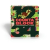
Following on the heels of the successful alphabetic phenomenon, Countablock features thick pages cut into the shape of each number, creating a sort of peek-through guessing game around the number form itself. One egg becomes...one chick! From snowmen to puddles & acorns to oaks, quantities are illustrated twice: both before & after their ”transformations.” As children interact with the pages, they will familiarise themselves not only with the numbers 1-100 & associated quantities, but with each numeral`s physicality -- angles, holes & curves, both front & back. Illustrated by hip British design team Peskimo, this fresh take on the 1-2-3s encourages readers to manipulate numbers in a whole new way. ...
Archived Product
£5.99
The subtitle
- 50 Odd Things to do in a Heritage Site (and other places)
- says it all. This is a book to take with you next

...
Archived Product

Coulonges-sur-L`Autize - Secondigny IGN 1527SB

Topographic survey of France at 1:25, 000 in IGN`s excellent TOP25 / Série Bleue series. All the maps are GPS compatible, with a 1km UTM grid plus latitude and longitude lines at 5’ intervals. Contours are at 5m intervals except for mountainous areas where the maps have contours at 10m intervals, vividly enhanced by hill shading and graphics for rocky terrain. Colouring with graphics indicates different types of vegetation or land use (deciduous or coniferous forests, moors, orchards, vineyards, etc). PLEASE NOTE: coverage of France at this scale is currently being revised – the format and the presentation of each title are indicated by the letters at the end of its Sheet Reference number (e.g. 0416ET, 3531ETR, 1923SB, etc.)MAPS WITH FULL TOURIST OVERPRINT & AN ENGLISH MAP
LEGEND: all TOP25 maps and the SB editions of Série Bleue have an overprint highlighting waymarked walking trails including long-distance GR routes and, where appropriate, ski routes. Symbols indicate campsites, gîtes d’etape, refuges, equestrian centres and other recreational facilities or sites, tourist information centres, cultural heritage, etc. Towns and locations of particular interest are highlighted.- ET or OT = single-sided TOP25 map covering approx. 29x21 km / 18x13 miles.- ETR or OTR = waterproof and tear resistant TOP25 map covering the same area as the corresponding ET or OT number, but double-sided, printed on a smaller size sheet with a good overlap between the sides.- SB = Série Bleue map with full tourist overprint; these maps, first introduced in summer
2014, each cover approx. 29x24km / 18x15 miles.SÉRIE BLEUE maps with numbers ending in E (Est) or O (Ouest): most editions now indicate the GR routes, but do not show any other tourist information. Map legend is in French only. Each map covers approx. 14x20km / 9x12 miles.
RIP - This product is no longer available on our network. It was last seen on 25.09.2019

This page now acts as a permanent archive for this product. Add more information using the comments box below to ensure it can still be found by future generations.

Use our search facility to see if it is available from an alternative contributor.
  • External links may include paid for promotion
  • Availability: Out Of Stock
  • Supplier: Stanfords
  • SKU: 9782758542001
Availability: In Stock
£12.99

Product Description

Topographic survey of France at 1:25, 000 in IGN`s excellent TOP25 / Série Bleue series. All the maps are GPS compatible, with a 1km UTM grid plus latitude & longitude lines at 5’ intervals. Contours are at 5m intervals except for mountainous areas where the maps have contours at 10m intervals, vividly enhanced by hill shading & graphics for rocky terrain. Colouring with graphics indicates different types of vegetation or land use (deciduous or coniferous forests, moors, orchards, vineyards, etc). PLEASE NOTE: coverage of France at this scale is currently being revised – the format & the presentation of each title are indicated by the letters at the end of its Sheet Reference number (e.g. 0416ET, 3531ETR, 1923SB, etc.)MAPS WITH FULL TOURIST OVERPRINT & AN ENGLISH MAP LEGEND: all TOP25 maps & the SB editions of Série Bleue have an overprint highlighting waymarked walking trails including long-distance GR routes &, where appropriate, ski routes. Symbols indicate campsites, gîtes d’etape, refuges, equestrian centres & other recreational facilities or sites, tourist information centres, cultural heritage, etc. Towns & locations of particular interest are highlighted.- ET or OT = single-sided TOP25 map covering approx. 29x 21 km / 18x 13 miles.- ETR or OTR = waterproof & tear resistant TOP25 map covering the same area as the corresponding ET or OT number, but double-sided, printed on a smaller size sheet with a good overlap between the sides.- SB = Série Bleue map with full tourist overprint; these maps, first introduced in summer 2014, each cover approx. 29x 24km / 18x 15 miles.SÉRIE BLEUE maps with numbers ending in E (Est) or O (Ouest): most editions now indicate the GR routes, but do not show any other tourist information. Map legend is in French only. Each map covers approx. 14x 20km / 9x 12 miles.

Reviews/Comments

Add New

Intelligent Comparison

Oooops!
We couldn't find anything!
Perhaps this product's unique.... Or perhaps we are still looking for comparisons!
Click to bump this page and we'll hurry up.

Price History

Vouchers

No voucher codes found.
Do you know a voucher code for this product or supplier? Add it to Insights for others to use.

Facebook

Jargon Buster

GPS - Global Positioning System - Global position using satellites
Summer - The season between Spring and Autumn. Usually the hottest season of the year
France - A state situated in Western Europe with several overseas territories.
Graphics - A general term for visual aspects of an item/display
Waterproof - Resistant to water, usualy specified by depth in metres
Size - is the measurement of how big an object is in space.
Km - Kilometre. A unit of measurement equal to 1000 metres.
Resistant - Something that can repel against something.
Reference - To prove evidence with a back up source.

Supplier Information

Stanfords
Stanfords was established in 1853 and opened their iconic Covent Garden flagship store in 1901. They have become the top retailer of maps, travel books and accessories in the UK and arguably offer the largest selection of maps and travel books worldwide. Famous names such as Captain Robert Falcon Scott, Ranulph Fiennes and Michael Palin have purchased from Stanfords. They now have a shop in Bristol and both stores together with other venues operate a calendar of events including talks, book signings and exhibitions. As a specialist map retailer, the map selection is comprehensive and includes road maps, street maps and walking maps from worldwide destinations, as well as a selection of world atlases and wall maps. Books include travel guides and travel literature. Stanfords also stock globes, from miniatures made of blue marble to magnificent floor-standing globes. The website features a selection of interesting articles on travel topics.
Page Updated: 2023-11-12 20:15:36

Community Generated Product Tags

Oh No! The productWIKI community hasn't generated any tags for this product yet!
Menu