More From Contributor

£10.95
A unique celebration of one of Britain's most beloved regions, beautifully bound & printed in colour. The perfect guide, gift or souvenir for visitors
- or an inspiration to anyone planning a trip to Cornwall. Illustrated & written by Jim Watson, a celebrated artist & writer with a number of award-winning books to his name. The latest title in the ' Sketchbook' series (including the Lake District, Cotswolds & London). Cornwall is one of Britain's most popular regions, attracting over 5 million visitors a year.
...
Archived Product
£11.99
Cornwall in the Slow Travel series from Bradt Guides, taking the slow approach, using local knowledge & the author`s endless curiosity, offers both visitors & seasoned residents alike the chance to discover what lies behind the immediate & obvious attractions of Britain`s favourite holiday destination. Many of Cornwall`s wildest or most curious corners as well as the exciting new range of places to eat, sleep or drink are often overlooked in the headlong race to get to the beach or the well-known tourist spots. ...
Archived Product
£5.95
Cornwall Street Atlas in a spiral-bound edition at a scale of 4 inches to 1 mile (1:15, 840) in a series of street atlases of English counties from the Geographers' A-Z Map Company. The atlas covers selected areas of the county including Bodmin, Bude, Callington, Camborne, Camelford, Hayle, Helston, Falmouth, Fowey, Lauceston, Liskeard, Lostwithiel, Mevagissey, Newquay, Padstow, Penryn, Penzance, Redruth, St. Austell, St. Just, Saltash, Torpoint, Truro & Wadebridge. Enlargements cover in greater detail the centres of St. Ives & Looe. The atlas has a comprehensive index including separate entries for places of interest such as cultural & sport or recreational facilities, historical sites, nature reserves & gardens. Also provided are lists of hospitals & hospices in the area covered by the atlas & a postcode map of the county. Current edition was published in 2008. ...
Archived Product
£7.99
This cycle map shows the National Cycle Network & local routes in this area. It covers the Cornwall area of the South West region of Engl&, including Penzance, Newquay, Bude & Bodmin. Cornwall has a unique identity which makes it one of the most popular holiday destinations in Engl&. Surrounded by the Atlantic & full of sandy beaches & dramatic cliffs, the quality of light made it popular with artists from the late 19th century onwards & St. Ives today is home to the Tate, a major art gallery. The hills in Cornwall come thick & fast, but there are also some wonderful traffic-free routes too. The Camel Trail follows the River Camel along a converted railway line from Bodmin to Padstow, & the Clay Trails are a network of traffic-free routes exploring the old mining area around the fascinating Eden Project near St Austell. This pocket-sized colour map shows clearly mapped on-road & traffic-free paths, easy to read contours, & detailed inset maps for the major towns & cities as well as recommended linking routes connecting the NCN with quiet roads. The map also features 4 day rides with directions & a description of the area, highlighting key cycle routes, local history & places of interest. ...
Archived Product
£6.99
The Cornwall Top 10 by Goldeneye is a pocket illustrated guide packed with all the essential information to enable you to make the most of a short break visiting this part of the country. The book offers suggestions for places to visit, stunning walks & things to do &

Includes::
14 pages atlas of this region. The guide highlights the prettiest scenic villages, pinpointing contemporary art galleries, magnificent churches & manor houses, historic building & sites, most stunning local walks & a full range of activities to get involved in. A wide range of interesting & quirky places to stay is presented with a brief introduction & contact details, from organic camp sites, hostelries & traditional country inn, to luxurious B&B & country house hotels. At the back of the book you will find a useful calendar of event & 14 pages road atlas for the whole Conrwall at 1:100, 000/1:120, 000 Approx.. The mapping offers road & topographic information & a wealth of symbols to locate places of interests, from historical building to campsites & Walk/ Nature trails. This pocket guide selects the best things to see & do in this region; it is the perfect companion for short breaks.

...
Archived Product
£12.95
This guidebook offers walkers 40 half to full day rambles on the coasts & inland hills of Cornwall. With routes ranging from short, 2 mile strolls to longer walks of over 8 miles, as well as plenty of opportunities to combine routes together, this guide provides plenty of variety for walkers of all abilities. The guidebook is divided into sections, including walks on Bodmin Moor (for which good navigational skills are required), the North coast, Penwith & West Cornwall, the Inland Mining Districts, Land`s End & the Lizard & Roseland Peninsulas. Cornwall has a lot to offer walkers; stunning coastal scenery & long stretches of wild moorl&, with quiet estuaries cutting through high & rocky headlands. Birdlife & wildlife, from choughs to falcons to seals are found throughout the county, as are historical sites from the neolithic, to Iron Age hill forts & a long history of mining. The towns & villages of Cornwall, from the popular spots such as St Ives, Newquay & Padstow, to quiet inland hamlets & tucked away fishing villages are also included & provide perfect bases for going out to explore the country. Alongside the 40 walking routes, this guidebook also

Includes::
plenty of practical information on getting to & around Cornwall, as well as details on each walk`s distance, timing, terrain, ascent & nearest town. Throughout the walk descriptions, there are details of places of interest along the way, as well as annotated OS maps & stunning photography. The result is an ideal companion to stepping out & exploring the best of Cornwall.

...
Archived Product
£11.99
Cornwall Walks in the Pathfinder Guides series, produced in association with Ordnance Survey & published by Crimson; comprising a range of walking guides to popular British destinations. Each Pathfinder guide

Includes::
28 varied walks ranging from easy strolls to exhilarating hikes & is accompanied by 1:25, 000 Ordnance Survey mapping with marked, colour-coded routes. Introductory sections profile the county or region covered, with recommendations on the best time to visit & a brief explanation of GPS. An

...
Archived Product
£2.99
The western half of Cornwall at 1:100, 000 on a handy size, 50x 35cm, double-sided contoured map from Croydecycle, printed on waterproof & tear-resistant synthetic paper & showing National Cycle routes & numerous local facilities, including campsites, pubs, etc. Coverage extends east to St Austell, Wadebridge & Port Isaac, overlapping with the publishers’ map of east Cornwall, &

Includes::
the Eden Project. Contours are at 30m intervals, with colouring for woodlands (indicating those with public access), sandy or pebble beaches, plus moors & common or other access l&. Interesting landscape & man- made features are highlighted with grading. Road network indicates A & B road numbers & has gradient markings. On roads which are part of the National Cycle Network route numbers are marked. Symbols indicate numerous facilities: campsites & caravan sites, pubs & cafes, car parks & picnic sites, local shops, cycle hire, tourist information, etc. National Grid coordinates are marked in the margins. Small panels provide street plans of central St Austell, Truro, Newquay, Wadebridge, St Ives, Penzance, Hayle, Helston, Redruth & Falmouth. To see other titles in this series please click on the series link.

...
Archived Product
£13.99
Britain`s most popular holiday destination has been left with no stone unturned in updating the second edition of Footprint`s full-colour guide, Cornwall with Kids. This popular guide provides you with the complete low-down on where to go, what to see & how to get the most from your family holiday. Cornwall is everything a family holiday should be
- braving surf, building sandcastles & sampling fish & chips. Perfect for any family budget, Cornwall with Kids offers insight into exactly where to pitch the tent, buy local food & plan days out for free, plus reviews of the top hotels along with the must-see attractions like the Eden Project & St Michael`s Mount. Whether it`s a day trip to the Isles of Scilly or finding the best beaches for rockpooling that takes your fancy, you won`t want to leave home without this full-colour guide.
- Teach the kids how to surf at one of the many acclaimed North Atlantic surf schools.
- Sample the culinary delights, full listings on where to find the best Cornish food, including that perfect pasty.
- Great days out, from the Eden Project to the Lost Gardens of Heligan. Whether the sun is blazing or the rain is pouring, there are tips here for all weather.


...
Archived Product

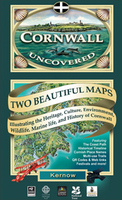
Cornwall Uncovered Illustrated Map

Cornwall on a lovely pictorial map presenting on one side the county’s “Heritage & Culture” and on the reverse its “Environment & Nature”, both accompanied with numerous panels providing more information by drawings and descriptions.Smaller roads are included where leading to the various highlighted locations, rather than the map presenting the whole of the road network. Interesting locations are presented by small drawings and many are also accompanied by brief notes. On each side, the road map is surrounded by numerous panels with drawings and/or text providing further information: from a recipe for a Cornish pasty to Cornish language, myth and legends, smuggling and ship wrecks, etc. The Environment & Nature side has lovely drawings of local birds and flowers.
RIP - This product is no longer available on our network. It was last seen on 25.09.2019

This page now acts as a permanent archive for this product. Add more information using the comments box below to ensure it can still be found by future generations.

Use our search facility to see if it is available from an alternative contributor.
  • Availability: Out Of Stock
  • Supplier: Stanfords
  • SKU: 9780992888701
Availability: In Stock
£6.99

Product Description

Cornwall on a lovely pictorial map presenting on one side the county’s “ Heritage & Culture” & on the reverse its “ Environment & Nature”, both accompanied with numerous panels providing more information by drawings & descriptions. Smaller roads are included where leading to the various highlighted locations, rather than the map presenting the whole of the road network. Interesting locations are presented by small drawings & many are also accompanied by brief notes. On each side, the road map is surrounded by numerous panels with drawings and/or text providing further information: from a recipe for a Cornish pasty to Cornish language, myth & legends, smuggling & ship wrecks, etc. The Environment & Nature side has lovely drawings of local birds & flowers.

Reviews/Comments

Add New

Intelligent Comparison

Oooops!
We couldn't find anything!
Perhaps this product's unique.... Or perhaps we are still looking for comparisons!
Click to bump this page and we'll hurry up.

Price History

Vouchers

No voucher codes found.
Do you know a voucher code for this product or supplier? Add it to Insights for others to use.

Facebook

Jargon Buster

Network - A link and communication between things. Often computers or people.
Language - the method of communication used in different areas. Humans and computers have many different languages.
Small - something that takes up less space than normal.
Road - a manmade lane or a path that is used to speed up travel.
Language - The way humans communicate either written and spoken.
Environment - The conditions and surrounding area.

Supplier Information

Stanfords
Stanfords was established in 1853 and opened their iconic Covent Garden flagship store in 1901. They have become the top retailer of maps, travel books and accessories in the UK and arguably offer the largest selection of maps and travel books worldwide. Famous names such as Captain Robert Falcon Scott, Ranulph Fiennes and Michael Palin have purchased from Stanfords. They now have a shop in Bristol and both stores together with other venues operate a calendar of events including talks, book signings and exhibitions. As a specialist map retailer, the map selection is comprehensive and includes road maps, street maps and walking maps from worldwide destinations, as well as a selection of world atlases and wall maps. Books include travel guides and travel literature. Stanfords also stock globes, from miniatures made of blue marble to magnificent floor-standing globes. The website features a selection of interesting articles on travel topics.
Page Updated: 2023-11-12 20:15:36

Community Generated Product Tags

Oh No! The productWIKI community hasn't generated any tags for this product yet!
Menu