
 United Kingdom
 France
 Germany
 Netherlands
 Sweden
 USA
USA
 Italy
Italy
 Spain
Spain
More From Contributor


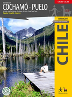
Cochamó - Puelo
First travel map of the valleys Cochamó, Manso and Puelo, an area known for the climing area at La Junta, wild water rivers and the Tagua Tagua private nature park. General map at 1:75, 000 scale, with altitude levels every 50m, hiking trails (distances in km and hours), lodgings, huts, camps etc. Detail map 1:25, 000 of La Junta with climbing and hiking routes and tourist services.Detail map 1:25, 000 of Parque Tagua Tagua with hiking trails (km and hours), huts and attractions.Landscape pictures and drawings of the local fauna. GPS compatible. Map developed with the support of the Institute for Cartography at the Dresden Technical University.

Product Description
Reviews/Comments
Add New
Vouchers
No voucher codes found.
Do you know a voucher code for this product or supplier? Add it to Insights for others to use.
Do you know a voucher code for this product or supplier? Add it to Insights for others to use.
 Denmark