More From Contributor

£11.19
Laminated waterproof edition of a detailed topographic map from the Ordnance Survey Explorer series, covering Bideford & Bradworthy (showing part of the South West Coast Path). Edition B2; Publication date May 2011 About this series: These highly detailed maps show all the administrative boundaries, settlements as small as isolated farms, the road network down to unfenced roads & country tracks, & field boundaries (hedges & drystone walls) which make navigation across the countryside much easier. Steep gradients on roads are indicated. Various landmarks, e.g. powerlines, archaeological sites, windmills, churches & lighthouses are shown & additional graphics indicate natural terrain features such as cliffs, scree, mud & vegetation variations. The contour interval is 5 metres in the lower parts of the country & 10 metres in the uplands, & spot heights are marked. Each map covers an area of 30 x 20km (i.e. approx. 19 x 12 miles), with some double-sided maps covering more, as indicated in the individual descriptions. The maps are fully GPS compatible, with the National Grid shown at 1km intervals & latitude & longitude indicated by margin ticks at 1'. The Explorer series has replaced the earlier, green-cover Pathfinder maps. The Explorer series is now complete & covers all of Engl&, Wales & Scotl&. Some sheets for popular areas like the National Parks are still branded as Outdoor Leisure (OL) maps, but are now included in this series as the cartography is the same as that in the Explorer Maps. The Explorer maps offer a substantial improvement on the Pathfinder series, with greater use of colour, larger area per map, & stronger emphasis on information for ramblers & tourists. This series is ideal for walking & other outdoor pursuits & each map shows a large amount of information for ramblers & tourists. Public rights of way are shown (except in Scotland), together with other routes with public access: National Trails & Recreational Paths, permitted paths & bridleways, & selected cycle routes. Open access land created under the Countryside & Rights of Way Act 2000 is marked. Tourist information

Includes::
caravan & camp sites, Park & Ride locations, recreation/leisure/sport centres, museums, historic buildings, English Heritage & National Trust sites, rural pubs, etc. The map legend is in English only, except for the tourist information content which is also in French & German.

...
Archived Product
£6.99
Clover Moon`s imagination is her best escape from a life of hardship in poverty-stricken Victorian London. When tragedy plunges her into a world of grief, Clover realizes that everything she loved about the place she called home is gone. Clover hears of a place she could run to, but where will she find the courage
- & the chance
- to break free? & could leaving her family be just what she needs to find a place that really feels like home? Introducing the brilliant & brave new heroine from the wonderful world of the bestselling & award-winning Jacqueline Wilson.

...
Archived Product
£12.99
Clover Moon`s imagination is her best escape from a life of hardship in poverty-stricken Victorian London. When tragedy plunges her into a world of grief, Clover realizes that everything she loved about the place she called home is gone. Clover hears of a place she could run to, but where will she find the courage
- & the chance
- to break free? & could leaving her family be just what she needs to find a place that really feels like home? Introducing the brilliant & brave new heroine from the wonderful world of the bestselling & award-winning Jacqueline Wilson.

...
Archived Product
£110.00
Sitting atop this antique sky hook is a h&-painted figure of a colorful juggling circus clown. Crafted from recycled metal, this balance toy is a replica of the classic home accessories used in the 18 & 19th centuries. When gently pushed by the curved handle, the clown will rock side to side on the candy-striped metal st&. This fun decoration will be a unique addition to any children`s bedroom or game room. If we do not have this item in stock we will order it for you from our supplier. Delivery generally takes 3 weeks within the UK. For overseas delivery queries please email sales@stanfords.co.uk ...
Archived Product
£12.99
Topographic survey of France at 1:25, 000 in IGN`s excellent TOP25 / Série Bleue series. All the maps are GPS compatible, with a 1km UTM grid plus latitude & longitude lines at 5’ intervals. Contours are at 5m intervals except for mountainous areas where the maps have contours at 10m intervals, vividly enhanced by hill shading & graphics for rocky terrain. Colouring with graphics indicates different types of vegetation or land use (deciduous or coniferous forests, moors, orchards, vineyards, etc). PLEASE NOTE: coverage of France at this scale is currently being revised – the format & the presentation of each title are indicated by the letters at the end of its Sheet Reference number (e.g. 0416ET, 3531ETR, 1923SB, etc.)MAPS WITH FULL TOURIST OVERPRINT & AN ENGLISH MAP LEGEND: all TOP25 maps & the SB editions of Série Bleue have an overprint highlighting waymarked walking trails including long-distance GR routes &, where appropriate, ski routes. Symbols indicate campsites, gîtes d’etape, refuges, equestrian centres & other recreational facilities or sites, tourist information centres, cultural heritage, etc. Towns & locations of particular interest are highlighted.- ET or OT = single-sided TOP25 map covering approx. 29x 21 km / 18x 13 miles.- ETR or OTR = waterproof & tear resistant TOP25 map covering the same area as the corresponding ET or OT number, but double-sided, printed on a smaller size sheet with a good overlap between the sides.- SB = Série Bleue map with full tourist overprint; these maps, first introduced in summer 2014, each cover approx. 29x 24km / 18x 15 miles.SÉRIE BLEUE maps with numbers ending in E (Est) or O (Ouest): most editions now indicate the GR routes, but do not show any other tourist information. Map legend is in French only. Each map covers approx. 14x 20km / 9x 12 miles. ...
Archived Product
£8.99
There’s a mystery that needs solving, & you’re just the detective to do it on the go with this Grab & Go version of the classic Cluedo game! Who killed the host of the fancy party? Where were they, & what weapon did they use? The gameboard has rooms to move in & secret passages to navigate faster, & if you’re a super sleuth you can keep track of the clues in your Detective Notebook & solve the case! When the case is solved, you can store all the cards & parts in the all-in-one game unit, until the next murder!- Grab & Go game is a compact mobile version of the Cluedo game- All-in-one game unit makes storage easy- Keep track of the elements of the case with the Detective Notebook- Guest, Room & Weapon cards tell you whodunit- For 3 to 6 players ...
Archived Product
£24.99
Cluedo London Edition is a take on the classic murder mystery game & has moved to the capital! This version sees murder scenes such as the study, the garage, kitchen etc. replaced by iconic locations of the capital like Tower Bridge, Covent Garden, Wembley & Soho. Reverend Green & Miss Scarlet & the other classic suspects have been swapped with urban characters like Malcolm Mustard the Mayor, Gus Green the footballer, Paul Plum the journalist etc., while the traditional murder weapons have been kept. Explore the city with Cluedo London, look for the clues to solve the murder mystery. This is a great game for the whole family & group of friends. Recommended for ages 8+. Content:- Gameboard- 6 coloured pawns- 6 suspects cards- 6 weapon cards- 9 London cards- Case Closed Envelope- 2 dice- Instructions- 1 pad of detective notebook sheets ...
Archived Product
£11.99
A perfect introduction to Japan & Japanese culture, this illustrated culture & travel guide contains loads of original drawings as well as the Japanese script for key words & phrases. Some people take photos, but artist Betty Reynolds captures memories with her paintbrush & watercolors. Clueless in Tokyo provides an outsider`s take on everyday life in Japan`s capital city--a place where vending machines talk, toilets can be terrifying, & centuries-old festivals unfold against a backdrop of space-age architecture. During the seven years Reynolds lived in Japan, she filled thirty sketchbooks with everything that caught her eye. Whether it`s fashion, food, sport, transport, seasonal rituals, or Japanese pastimes, each vibrant sketch is a delight, & Reynolds` witty h&-lettered captions in both Japanese & English provide an entertaining resource for beginning learners of the Japanese language. Adult students & travelers alike will find this Japan travel guide to be a charming & insightful addition to their trip. ...
Archived Product
£7.99
Romanian towns of Cluj Napoca & Oradea on a double-sided map from the Budapest-based Cartographia. Each town is shown with an enlargement of its central area, an index including lists of sights & facilities, plus a small road map of the surrounding region. On one side is a plan of Cluj Napoca, on the reverse is Oradea, both with enlargements for the town centre. The main plans are at 1:15, 000, highlight main traffic arteries, name important buildings & places of interest, & indicate various facilities including selected tourist accommodation, campsites, car parks & petrol stations, etc. Each town has an index of both streets & important buildings / sights. Map legend

Includes::
English.

...
Archived Product
£12.99
Topographic survey of France at 1:25, 000 in IGN`s excellent TOP25 / Série Bleue series. All the maps are GPS compatible, with a 1km UTM grid plus latitude & longitude lines at 5’ intervals. Contours are at 5m intervals except for mountainous areas where the maps have contours at 10m intervals, vividly enhanced by hill shading & graphics for rocky terrain. Colouring with graphics indicates different types of vegetation or land use (deciduous or coniferous forests, moors, orchards, vineyards, etc). PLEASE NOTE: coverage of France at this scale is currently being revised – the format & the presentation of each title are indicated by the letters at the end of its Sheet Reference number (e.g. 0416ET, 3531ETR, 1923SB, etc.)MAPS WITH FULL TOURIST OVERPRINT & AN ENGLISH MAP LEGEND: all TOP25 maps & the SB editions of Série Bleue have an overprint highlighting waymarked walking trails including long-distance GR routes &, where appropriate, ski routes. Symbols indicate campsites, gîtes d’etape, refuges, equestrian centres & other recreational facilities or sites, tourist information centres, cultural heritage, etc. Towns & locations of particular interest are highlighted.- ET or OT = single-sided TOP25 map covering approx. 29x 21 km / 18x 13 miles.- ETR or OTR = waterproof & tear resistant TOP25 map covering the same area as the corresponding ET or OT number, but double-sided, printed on a smaller size sheet with a good overlap between the sides.- SB = Série Bleue map with full tourist overprint; these maps, first introduced in summer 2014, each cover approx. 29x 24km / 18x 15 miles.SÉRIE BLEUE maps with numbers ending in E (Est) or O (Ouest): most editions now indicate the GR routes, but do not show any other tourist information. Map legend is in French only. Each map covers approx. 14x 20km / 9x 12 miles. ...
Archived Product

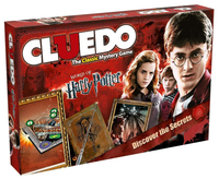
Cluedo - Harry Potter

DARK FORCES ARE AT WORK… A friend has seemingly vanished. Playing Harry, Ron, Hermione, Ginny, Luna or Neville, you must try to discover WHO did it, WHAT spell or item they used and WHERE the student was attacked. Was it Fenrir Greyback with a Cursed Necklace in the Forbidden Forest? Use the Floo Network to travel faster through the wizarding world... but watch out for unlit fireplaces. When you`re sure of your facts, go to The Burrow to make your final accusation and win the game!
RIP - This product is no longer available on our network. It was last seen on 25.09.2019

This page now acts as a permanent archive for this product. Add more information using the comments box below to ensure it can still be found by future generations.

Use our search facility to see if it is available from an alternative contributor.
  • Availability: Out Of Stock
  • Supplier: Stanfords
  • SKU: 5036905028431
Availability: In Stock
£44.99

Product Description

DARK FORCES ARE AT WORK… A friend has seemingly vanished. Playing Harry, Ron, Hermione, Ginny, Luna or Neville, you must try to discover WHO did it, WHAT spell or item they used & WHERE the student was attacked. Was it Fenrir Greyback with a Cursed Necklace in the Forbidden Forest? Use the Floo Network to travel faster through the wizarding world... but watch out for unlit fireplaces. When you`re sure of your facts, go to The Burrow to make your final accusation & win the game!

Reviews/Comments

Add New

Intelligent Comparison

Oooops!
We couldn't find anything!
Perhaps this product's unique.... Or perhaps we are still looking for comparisons!
Click to bump this page and we'll hurry up.

Price History

Vouchers

No voucher codes found.
Do you know a voucher code for this product or supplier? Add it to Insights for others to use.

Facebook

Jargon Buster

Forest - A area with a high density of trees
Watch - A small clock designed to be worn on a person
Dark - A colour which absorbs visable ligt so apears less light than objects that reflect light
World - A physical grouping, commonly used to describe earth and everything associated with ti
Network - A link and communication between things. Often computers or people.
Necklace - A chain that is worn round the neck usually for fashion or sentimental reasons.

Supplier Information

Stanfords
Stanfords was established in 1853 and opened their iconic Covent Garden flagship store in 1901. They have become the top retailer of maps, travel books and accessories in the UK and arguably offer the largest selection of maps and travel books worldwide. Famous names such as Captain Robert Falcon Scott, Ranulph Fiennes and Michael Palin have purchased from Stanfords. They now have a shop in Bristol and both stores together with other venues operate a calendar of events including talks, book signings and exhibitions. As a specialist map retailer, the map selection is comprehensive and includes road maps, street maps and walking maps from worldwide destinations, as well as a selection of world atlases and wall maps. Books include travel guides and travel literature. Stanfords also stock globes, from miniatures made of blue marble to magnificent floor-standing globes. The website features a selection of interesting articles on travel topics.
Page Updated: 2023-11-12 20:15:36

Community Generated Product Tags

Oh No! The productWIKI community hasn't generated any tags for this product yet!
Menu