More From Contributor

£30.00
Concentrating on the eighty most important sites in Britain & Irel&, this illustrated guide to stone circles & landscape temples is the first work on the subject to combine stunning photography with scientific survey. Stone circles are one of the enticements & fascinations of prehistory. The emptiness & mystery of these sites & their weathered stones have captivated, perplexed, & attracted visitors from all over the world.

Max Milligan's images convey the serene beauty & unique aura of these sites, & range from descriptive & informative views to strikingly abstract & inspiring compositions. The text by Aubrey Burl, the acknowledged authority on the subject, offers detailed historical accounts & descriptions of the sites, & recounts the powerful myths & legends that have surrounded them & persist to this day.

...
Archived Product
£8.99
As a young girl, Beryl Markham was brought to Kenya from Britain by parents dreaming of a new life. For her mother, the dream quickly turned sour, & she returned home; Beryl was brought up by her father, who switched between indulgence & heavy-handed authority, allowing her first to run wild on their farm, then incarcerating her in the classroom. The scourge of governesses & serial absconder from boarding school, by the age of sixteen Beryl had been catapulted into a disastrous marriage
- but it was in facing up to this reality that she took charge of her own destiny. Scandalizing high society with her errant behaviour, she left her husband & became the first woman ever to hold a professional racehorse trainer`s licence. After falling in with the notoriously hedonistic & gin-soaked Happy Valley set, Beryl soon became embroiled in a complex love triangle with the writer Karen Blixen & big game-hunter Denys Finch Hatton (immortalized in Blixen`s memoir Out of Africa). It was this unhappy affair which set tragedy in motion, while awakening Beryl to her truest self, & to her fate: to fly.
...
Archived Product
£12.99
Presenting a series of 50 circular walks along & around the Pennine Way, this title also aims to provide an appreciation of this wonderful part of the English Countryside. The walks included were adopted by the Countryside Agency for its 40th anniversary celebration of the Pennine Way, with an event called ' Walk the Way in a Day'. ...
Archived Product
£8.99
In her new collection, Katherine Gallagher draws on a rich inheritance from her different worlds: Australia, Britain
- particularly
...
Archived Product
£10.99
A boxer-turned-hitman faces an impossible mission to kill his brother; an old lady sets up a gang of her own teenage vigilantes after being mugged herself; a village boy faces the gruesome end of his beloved pet piglet; a retired geography teacher dreams of places he`s never been; a clown on the make talks an impoverished lion tamer into selling his lion to gangsters; &, a fading beauty is courted by a suitor with suspiciously scaly hands
- Drawing on the monsters & myths of Balkan folklore, the brutal reality of the Communist regime, & the dazzling magic of Enev`s own imagination, these stories have an almost hypnotic & surreal quality. Absurd, both painfully funny & deeply sad, Circus Bulgaria, reaches straight into the cracked heart of the Eastern Europe.
...
Archived Product
£6.99
Micah`s beloved grandfather is gravely sick, but all is not lost. Years ago, his grandfather visited a mysterious circus where he was promised a miracle by a man who could bend light. But who is this stranger, will he keep his promise, & does the magical Circus Mirandus really exist? ...
Archived Product
£6.39
A detailed topographic map of Cirencester & Swindon from the Ordnance Survey Explorer series, covering Fairford & Cricklade (showing part of the Thames Path). Edition A2; Publication date March 2009 About this series: These highly detailed maps show all the administrative boundaries, settlements as small as isolated farms, the road network down to unfenced roads & country tracks, & field boundaries (hedges & drystone walls) which make navigation across the countryside much easier. Steep gradients on roads are indicated. Various landmarks, e.g. powerlines, archaeological sites, windmills, churches & lighthouses are shown & additional graphics indicate natural terrain features such as cliffs, scree, mud & vegetation variations. The contour interval is 5 metres in the lower parts of the country & 10 metres in the uplands, & spot heights are marked. Each map covers an area of 30 x 20km (i.e. approx. 19 x 12 miles), with some double-sided maps covering more, as indicated in the individual descriptions. The maps are fully GPS compatible, with the National Grid shown at 1km intervals & latitude & longitude indicated by margin ticks at 1'. The Explorer series has replaced the earlier, green-cover Pathfinder maps. The Explorer series is now complete & covers all of Engl&, Wales & Scotl&. Some sheets for popular areas like the National Parks are still branded as Outdoor Leisure (OL) maps, but are now included in this series as the cartography is the same as that in the Explorer Maps. The Explorer maps offer a substantial improvement on the Pathfinder series, with greater use of colour, larger area per map, & stronger emphasis on information for ramblers & tourists. This series is ideal for walking & other outdoor pursuits & each map shows a large amount of information for ramblers & tourists. Public rights of way are shown (except in Scotland), together with other routes with public access: National Trails & Recreational Paths, permitted paths & bridleways, & selected cycle routes. Open access land created under the Countryside & Rights of Way Act 2000 is marked. Tourist information

Includes::
caravan & campsites, Park & Ride locations, recreation/leisure/sport centres, museums, historic buildings, English Heritage & National Trust sites, rural pubs, etc. The map legend is in English only, except for the tourist information content which is also in French & German.

...
Archived Product
£14.99
Cirencester, Swindon, Fairford & Cricklade area on a detailed topographic & GPS compatible map No. 169, waterproof version, from the Ordnance Survey’s 1:25, 000 Explorer series. MOBILE DOWNLOADS: this title & all the other OS Explorer maps include a code for downloading after purchase the digital version onto your smartphone or tablet for viewing on the OS smartphone app.OS EXPLORER SERIES: to see the list of all the titles in the OS Explorer series, both paper & waterproof versions, please click on the series link. The Explorer series, Ordnance Survey’s most detailed maps recommended for anyone enjoying outdoor activities, provides topographic coverage of Great Britain at 1:25, 000 on GPS compatible maps with hiking trails, cycling routes & extensive tourist information. Each printed map is available either on paper or as a waterproof & tear-resistant OS Active Map, as indicated in its title. Britain’s National Parks & other areas of particular tourist interest are presented on often double-sided OL (Outdoor Leisure) maps, whilst most standard format Explorers cover an area of 30 x 20km (approx. 19 x 12 miles). All three versions (paper, waterproof & digital) are the same & provide plenty of recreational & tourist information, indicating the traditional public right of way paths (except in Scotland where different laws apply), including bridleways & byways. National Trails & other long-distance paths are marked, as well as permissive footpaths or bridleways & on-road or traffic-free cycle routes with, where appropriate, their National/ Regional Cycle Network numbers. Boundaries of access land are clearly marked. A wide range of symbols provides additional tourist information, highlighting camping & caravanning sites, information offices & visitors’ centres, parking & picnicking places, country pubs, sport & recreational facilities including cycle hire locations & mountain biking trails, historic buildings & museums, etc. Exceptionally clear presentation of the landscape is provided by contours at 5m or in the uplands at 10m intervals, with additional spot heights plus colouring and/or graphics for different types of woodlands, orchards, heath, marshl&, scree or boulders, & other topographic features. For GPS users the maps have British National Grid lines at 1km intervals, with latitude & longitude given by margin ticks at 1`. Clearly laid out map legend

Includes::
French & German translations for the tourist information symbols.

...
Archived Product
£8.99
Cirencester, Swindon, Fairford & Cricklade area on a detailed topographic & GPS compatible map No. 169, paper version, from the Ordnance Survey’s 1:25, 000 Explorer series. MOBILE DOWNLOADS: this title & all the other OS Explorer maps include a code for downloading after purchase the digital version onto your smartphone or tablet for viewing on the OS smartphone app.OS EXPLORER SERIES: to see the list of all the titles in the OS Explorer series, both paper & waterproof versions, please click on the series link. The Explorer series, Ordnance Survey’s most detailed maps recommended for anyone enjoying outdoor activities, provides topographic coverage of Great Britain at 1:25, 000 on GPS compatible maps with hiking trails, cycling routes & extensive tourist information. Each printed map is available either on paper or as a waterproof & tear-resistant OS Active Map, as indicated in its title. Britain’s National Parks & other areas of particular tourist interest are presented on often double-sided OL (Outdoor Leisure) maps, whilst most standard format Explorers cover an area of 30 x 20km (approx. 19 x 12 miles). All three versions (paper, waterproof & digital) are the same & provide plenty of recreational & tourist information, indicating the traditional public right of way paths (except in Scotland where different laws apply), including bridleways & byways. National Trails & other long-distance paths are marked, as well as permissive footpaths or bridleways & on-road or traffic-free cycle routes with, where appropriate, their National/ Regional Cycle Network numbers. Boundaries of access land are clearly marked. A wide range of symbols provides additional tourist information, highlighting camping & caravanning sites, information offices & visitors’ centres, parking & picnicking places, country pubs, sport & recreational facilities including cycle hire locations & mountain biking trails, historic buildings & museums, etc. Exceptionally clear presentation of the landscape is provided by contours at 5m or in the uplands at 10m intervals, with additional spot heights plus colouring and/or graphics for different types of woodlands, orchards, heath, marshl&, scree or boulders, & other topographic features. For GPS users the maps have British National Grid lines at 1km intervals, with latitude & longitude given by margin ticks at 1`. Clearly laid out map legend

Includes::
French & German translations for the tourist information symbols.

...
Archived Product
£11.19
Laminated waterproof edition of a detailed topographic map of Cirencester & Swindon from the Ordnance Survey Explorer series, covering Fairford & Cricklade (showing part of the Thames Path). Edition A2; Publication date April 2009 About this series: These highly detailed maps show all the administrative boundaries, settlements as small as isolated farms, the road network down to unfenced roads & country tracks, & field boundaries (hedges & drystone walls) which make navigation across the countryside much easier. Steep gradients on roads are indicated. Various landmarks, e.g. powerlines, archaeological sites, windmills, churches & lighthouses are shown & additional graphics indicate natural terrain features such as cliffs, scree, mud & vegetation variations. The contour interval is 5 metres in the lower parts of the country & 10 metres in the uplands, & spot heights are marked. Each map covers an area of 30 x 20km (i.e. approx. 19 x 12 miles), with some double-sided maps covering more, as indicated in the individual descriptions. The maps are fully GPS compatible, with the National Grid shown at 1km intervals & latitude & longitude indicated by margin ticks at 1'. The Explorer series has replaced the earlier, green-cover Pathfinder maps. The Explorer series is now complete & covers all of Engl&, Wales & Scotl&. Some sheets for popular areas like the National Parks are still branded as Outdoor Leisure (OL) maps, but are now included in this series as the cartography is the same as that in the Explorer Maps. The Explorer maps offer a substantial improvement on the Pathfinder series, with greater use of colour, larger area per map, & stronger emphasis on information for ramblers & tourists. This series is ideal for walking & other outdoor pursuits & each map shows a large amount of information for ramblers & tourists. Public rights of way are shown (except in Scotland), together with other routes with public access: National Trails & Recreational Paths, permitted paths & bridleways, & selected cycle routes. Open access land created under the Countryside & Rights of Way Act 2000 is marked. Tourist information

Includes::
caravan & campsites, Park & Ride locations, recreation/leisure/sport centres, museums, historic buildings, English Heritage & National Trust sites, rural pubs, etc. The map legend is in English only, except for the tourist information content which is also in French & German.

...
Archived Product

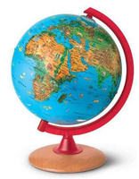
Circus Globe For Kids Illuminated

The Nova Rico 25cm Circus Illuminated Children`s Globe features different animals from around the world. The animals are highlighted on the globe in their natural habitats for easy reference. It`s a great tool for teaching kids about geography as well as the environment. Shows main political boundaries and world`s physical features. All wording on the globe is in English.Genuine wooden base.
RIP - This product is no longer available on our network. It was last seen on 25.09.2019

This page now acts as a permanent archive for this product. Add more information using the comments box below to ensure it can still be found by future generations.

Use our search facility to see if it is available from an alternative contributor.
  • Availability: Out Of Stock
  • Supplier: Stanfords
  • SKU: 9786000502294
Availability: In Stock
£60.00

Product Description

The Nova Rico 25cm Circus Illuminated Children`s Globe features different animals from around the world. The animals are highlighted on the globe in their natural habitats for easy reference. It`s a great tool for teaching kids about geography as well as the environment. Shows main political boundaries & world`s physical features. All wording on the globe is in English. Genuine wooden base.

Reviews/Comments

Add New

Intelligent Comparison

Oooops!
We couldn't find anything!
Perhaps this product's unique.... Or perhaps we are still looking for comparisons!
Click to bump this page and we'll hurry up.

Price History

Vouchers

No voucher codes found.
Do you know a voucher code for this product or supplier? Add it to Insights for others to use.

Facebook

Jargon Buster

Wooden - Something that is made from wood, from trees
Physical - Used to describe strength or visual properties of an item
World - A physical grouping, commonly used to describe earth and everything associated with ti
Natural - not manmade
Genuine - A product that is "real", from the manufactuer, not a fake.
Children - A young life form within the early stages of physical development,
Reference - To prove evidence with a back up source.
Kids - A young child.
Environment - The conditions and surrounding area.

Supplier Information

Stanfords
Stanfords was established in 1853 and opened their iconic Covent Garden flagship store in 1901. They have become the top retailer of maps, travel books and accessories in the UK and arguably offer the largest selection of maps and travel books worldwide. Famous names such as Captain Robert Falcon Scott, Ranulph Fiennes and Michael Palin have purchased from Stanfords. They now have a shop in Bristol and both stores together with other venues operate a calendar of events including talks, book signings and exhibitions. As a specialist map retailer, the map selection is comprehensive and includes road maps, street maps and walking maps from worldwide destinations, as well as a selection of world atlases and wall maps. Books include travel guides and travel literature. Stanfords also stock globes, from miniatures made of blue marble to magnificent floor-standing globes. The website features a selection of interesting articles on travel topics.
Page Updated: 2023-11-12 20:15:36

Community Generated Product Tags

Oh No! The productWIKI community hasn't generated any tags for this product yet!
Menu