More From Contributor

£12.99
1:25, 000 scale hiking map to Cinque Terre including Bonassola, Vernazza, Porto Venere & Lerici. Published in association with the CAI, the Italian Alpine Club, who are responsible for the trails. Trails are marked on the map. The key information & more detailed information on the rear of the sheet are in Italian, German & English. Printed on waterproof, tear-proof paper. ...
Archived Product
£9.99
Cinque Terre on a GPS compatible hiking map from Freytag & Berndt, with long-distance routes & local waymarked paths, cycling routes, campsites, places of interest, etc. The maps

Includes::
the Portofino peninsula, as shown on the area coverage image. The base map has contours at 50m intervals, supplemented by relief shading. National parks & protected areas are clearly marked. An overprint highlights local hiking routes, indicating their numbers & waymarking. Also shown are local sections of long-distance routes & special circuits: Alta Via del Monti Liguri, Alta Via del Golfo, Alta Via delle Cinque Terre, Sentiero Verdeazurro & Trekking Lunigiana. The map also shows local bridleways & mountain bike routes. A wide range of symbols indicate various facilities & places of interest, including campsites, sport & recreational sites, museums & interesting churches, etc. Railway stations are clearly marked, as are coastal ferry connections. The map has a 2-km UTM grid. Map legend

Includes::
English. A separate multilingual booklet has 11 pages of text in English with a general introduction to the area, plus descriptions of main interesting locations & a selection of hiking recommendations.


...
Archived Product
£12.99
Cinque Terre National Park along the Ligurian coast at 1:25, 000 on a contoured & GPS compatible map from Edizioni Multigraphic presenting local hiking trails with their new official waymarking numbers. Coverage extends from Deiva Marina in the west to Seno di Fosola bay, so does not include the south-easternmost tip of the Park around Portovenere or La Spezia. Contours are at 20m intervals, with relief shading & spot heights. Hiking trails are annotated with their official waymarking – please see the note below – at the map also indicate picturesque locations, visitors’ centres, museums, etc. The map has a 1km UTM grid, plus latitude & longitude margin ticks at 5’ intervals. Map legend & notes about the area include English.PLEASE NOTE: the map, published in summer 2016, has a list of hiking trails with a note “ Hiking trails here are represented by the new numbering plan according to the standard of Regione Liguria. The full list of trails with the walking times in ascent & descent is reported below. Old trail numbers, if available, are reported in brackets. The update of signage to the new numbering plan is in progress. Signals with the old trail numbers might still be present in the field.” To see the list of titles in this Ed. Multigraphic series please click on the series link. ...
Archived Product
£12.99
If you enjoyed Sunflower`s best-selling guide to Sorrento & the Amalfi Coast, you`re sure to love the Cinque Terre & Riviera di Levante
-
...
Archived Product
£10.99
Cinque Terra area of the Ligurian Coast on a double-sided, contoured & GPS compatible recreational map at 1:50, 000 from Kompass, printed on durable, waterproof & tear-resistant synthetic paper. Coverage Montemarcello Magra Regional Park. In addition to numerous local hiking trails & long-distance routes such as the Alta Via dei Monti Liguri or Alta via del Golfo, the map also shows cycling routes & a selection of mountain bike routes.KOMPASS HIKING MAPS OF ITALY – TO SEE THE OTHER TITLES IN THIS SERIES PLEASE CLICK ON THE SERIES LINK. The series covers the northern part of the Italian Alps, the lake region of Lombardy, the Dolomites, selected parts of Tuscany & Umbria, the Sorrento Peninsula, central Sardinia & the islands of the Tyrrhenian Sea. Coverage of the Dolomites by Kompass at more detailed scales (mainly 1:25, 000) is listed on our website in a separate series (please search for SI00000405). Kompass are Europe’s largest publishers of walking maps, with extensive coverage of hiking areas in other countries, all listed on our website.CARTOGRAPHY: Contour interval varies according to the terrain, 40m in most titles. Colouring and/or graphics show different types of the terrain, including woodlands, vineyards, heath, exposed rock, etc. All the maps highlight local hiking paths indicating, where appropriate, long-distance routes or via ferrata trails. Symbols show various types of accommodation such as selected inns & hotels, campsites, mountain huts & refuges, etc. Most titles also include cycle or mountain bike trails and/or ski routes. GPS COMPATIBILITY & MAP LEGEND: All the titles are GPS compatible with a UTM grid, unless indicated to the contrary in the individual description. Map legend

Includes::
English.DURABILITY: Many new editions are now published on sturdy, waterproof & tear-resistant synthetic paper, as indicated in the individual description.BOOKLETS: PLEASE NOTE BEFORE ORDERING!
- Many titles come with a booklet describing the area and/or various hiking routes. Unless indicated in the individual description that the booklet

Includes::
English, these booklets are in Italian & German only. The booklets are not necessary to use the maps since, as stated above, full English language map legend is provided.


...
Archived Product
£11.99
From the creator of the critically acclaimed Where the Forest Meets the Sea & Mirror, comes a poetic, eco-conscious picture book which explores the complex, interdependency of nature. This is the story of the little-known Bar-tailed Godwit who, following invisible pathways that have been used for thousands of years, undertakes the longest unbroken migration of any bird, a total of 11, 000 kilometres, flying from their breeding grounds in Alaska across the Pacific Ocean to Australia or New Zeal&. Facing hunger & treacherous conditions to reach their destination, their flight is one of bravery, tenacity & strength, & Jeannie`s stunning mixed media collages, inspired first-hand by the spectacular landscapes of Alaska & China, will amaze readers, & take them on an extraordinary visual journey to the corners of our Earth. ...
Archived Product
£19.99
From the creator of the critically acclaimed Where the Forest Meets the Sea & Mirror, comes a poetic, eco-conscious picture book which explores the complex, interdependency of nature. This is the story of the little-known Bar-tailed Godwit who, following invisible pathways that have been used for thousands of years, undertakes the longest unbroken migration of any bird, a total of 11, 000 kilometres, flying from their breeding grounds in Alaska across the Pacific Ocean to Australia or New Zeal&. Facing hunger & treacherous conditions to reach their destination, their flight is one of bravery, tenacity & strength, & Jeannie`s stunning mixed media collages, inspired first-hand by the spectacular landscapes of Alaska & China, will amaze readers, & take them on an extraordinary visual journey to the corners of our Earth. ...
Archived Product
£16.99
Describes the life of an Englishman in Japan, a banker by day & a writer by night, & what it feels like to be a chameleon in a pin-stripe suit: the strange sensation of returning to Japan, as another persona comes back to life, part Japanese, part gaijin; the gradual internalization of an alien culture; & the bittersweet adventure of becoming someone other. The book records the experience of an outsider in a country where the group is all-powerful, & of an individual in a society where conformity is an almost religious duty. It describes a journey through the looking glass land of a foreigner in Tokyo & the invisible country which exists in the mind of the Japanese, into the interior
- in search of the heart of Japan.
...
Archived Product
£8.99
Magic, to a sailor, is harnessing the wind
- getting something for nothing
- the surprise of a gust, the boon of a side-wind

...
Archived Product
£4.99
From Lucy Wadham, the bestselling author of The Secret Life of France, Heads & Straights is an autobiographical tale of bohemians, punk, the King`s Road in the 1970s & family
- part of a series of twelve books tied to the twelve lines of the London Underground, as Tfl celebrates 150 years of the Tube with Penguin. It is also available in a boxset. ”A rich, vital family saga, & a feat of narrative compression”. (The Times). ” Authors include the masterly John Lanchester, the children of Kids Company, comic John O` Farrell & social geographer Danny Dorling. Ranging from the polemical to the fantastical, the personal to the societal, they offer something for every taste. All experience the city as a cultural phenomenon & notice its nature & its people. Read individually they`re delightful small reads, pulled together they offer a particular portrait of a global city”. (Evening Standard). ” Exquisitely diverse”. (The Times). ” Eclectic & broad-minded.. .beautifully designed”. (Tom Cox, Observer). ”A fascinating collection with a wide range of styles & themes. The design qualities are excellent, as you might expect from Penguin with a consistent look & feel while allowing distinctive covers for each book. This is a very pleasing set of books”. (A Common Reader blog). ” The contrasts & transitions between books are as stirring as the books themselves.. .A multidimensional literary jigsaw”. (Londonist). ”A series of short, sharp, city-based vignettes
- some personal, some political & some pictorial.. .each inimitable author finds that our city is complicated but ultimately connected, full of wit, & just the right amount of grit”. (Fabric Magazine). ”A collection of beautiful books”. (Grazia). [ Praise for Lucy Wadham]: ” Penetrating insight & dry observation”. (Independent). ” Beautifully clever & intellectually challenging”. (Good Housekeeping). ” Effortless wit & keen intelligence”. (New Statesman). Lucy Wadham was born in London & has lived in France for the past twenty years. She is the author of Lost, shortlisted for the Macallan Gold Dagger for Fiction. Her most recent book is The Secret Life of France.

...
Archived Product

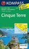
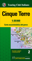
Cinque Terre TCI Map & Guide

Map and guide to discover and visit the Cinque Terre National Park, a World Heritage Site. With its overhanging shores, bays and small beaches, thousands of kilometers of dry stone walls surrounding the terraces where vineyards are cultivated and its scenic trails, its natural features are extraordinary.
RIP - This product is no longer available on our network. It was last seen on 25.09.2019

This page now acts as a permanent archive for this product. Add more information using the comments box below to ensure it can still be found by future generations.

Use our search facility to see if it is available from an alternative contributor.
  • Availability: Out Of Stock
  • Supplier: Stanfords
  • SKU: 9788836572106
Availability: In Stock
£14.99

Product Description

Map & guide to discover & visit the Cinque Terre National Park, a World Heritage Site. With its overhanging shores, bays & small beaches, thousands of kilometers of dry stone walls surrounding the terraces where vineyards are cultivated & its scenic trails, its natural features are extraordinary.

Reviews/Comments

Add New

Intelligent Comparison

Oooops!
We couldn't find anything!
Perhaps this product's unique.... Or perhaps we are still looking for comparisons!
Click to bump this page and we'll hurry up.

Price History

Vouchers

No voucher codes found.
Do you know a voucher code for this product or supplier? Add it to Insights for others to use.

Facebook

Jargon Buster

Dry - A term used to describe an item with has little or no water present
Dry - A term used in wine making to describe the lack of sugar (sweetness)
World - A physical grouping, commonly used to describe earth and everything associated with ti
Stone - Or Rock is a naturally occuring mineral categorised into three types, Igneous, Sedimentary and Metamorphic
Natural - not manmade
Small - something that takes up less space than normal.

Supplier Information

Stanfords
Stanfords was established in 1853 and opened their iconic Covent Garden flagship store in 1901. They have become the top retailer of maps, travel books and accessories in the UK and arguably offer the largest selection of maps and travel books worldwide. Famous names such as Captain Robert Falcon Scott, Ranulph Fiennes and Michael Palin have purchased from Stanfords. They now have a shop in Bristol and both stores together with other venues operate a calendar of events including talks, book signings and exhibitions. As a specialist map retailer, the map selection is comprehensive and includes road maps, street maps and walking maps from worldwide destinations, as well as a selection of world atlases and wall maps. Books include travel guides and travel literature. Stanfords also stock globes, from miniatures made of blue marble to magnificent floor-standing globes. The website features a selection of interesting articles on travel topics.
Page Updated: 2023-11-12 20:15:36

Community Generated Product Tags

Oh No! The productWIKI community hasn't generated any tags for this product yet!
Menu