More From Contributor
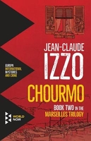
£2.95
Chorley North in 1909 in a fascinating series of reproductions of old Ordnance Survey plans in the Alan Godfrey Editions, ideal for anyone interested in the history of their neighbourhood or family. Selected towns in Great Britain & Ireland are covered by maps showing the extent of urban development in the last decades of the 19th & early 20th century. In this title: the map covers the northern part of Chorley, stretching from Hollinshead Street northward to Hartwood Hall, & from Park Road eastward to Lower Healey Wood. Features include Talbot Mills, Lower Healey Bleach Works, Lancaster Canal, Heapey Bleach Works, Knowley Top, Botany Bay, Fosterfield Mill, Canal Mill, railway lines & engine shed, Diamond Mills, St Peter's church, North Street Mills, Chorley Hall Farm, Hartwood Green. A commercial directory, entries A-H, is included on the reverse. About the Alan Godfrey Editions of the 25 ...
Archived Product
£3.50
Chorleywood in 1896 in a fascinating series of reproductions of old Ordnance Survey plans in the Alan Godfrey Editions, ideal for anyone interested in the history of their neighbourhood or family. The map is double-sided to give maximum coverage of the town. The main map covers the town centre, extending westward to Foxholes, & northward to Butts Close. Features include St Mary`s church, The Priory, Windmill Hill, The Grove, Holy Saviour`s church, Whinbush Grove, Lavender Distillery, Leather Dressing Works, engine shed, Market Place, High Street, Rosenburg, Infirmary, Workhouse, cemetery, etc. On the reverse is a portion of adjacent sheet 12.02 extending coverage eastward to include the station. About the Alan Godfrey Editions of the 25” OS Series: Selected towns in Great Britain & Ireland are covered by maps showing the extent of urban development in the last decades of the 19th & early 20th century. The plans have been taken from the Ordnance Survey mapping & reprinted at about 15 inches to one mile (1:4, 340). On the reverse most maps have historical notes & many also include extracts from contemporary directories. Most maps cover about one mile (1.6kms) north/south, one & a half miles (2.4kms) across; adjoining sheets can be combined to provide wider coverage.FOR MORE INFORMATION & A COMPLETE LIST OF ALL AVAILABLE TITLES PLEASE CLICK ON THE SERIES LINK. ...
Archived Product
£3.50
Chorlton cum Hardy & Stretford in 1905 in a fascinating series of reproductions of old Ordnance Survey plans in the Alan Godfrey Editions, ideal for anyone interested in the history of their neighbourhood or family. The map covers the eastern part of Stretford & western Chorlton cum Hardy. Coverage stretches from Chester Road eastward to Cavendish Road, & from Longford Bridge & Firs Farm southward to Beech Road. Features include Stretford station on MSJA line, Edge Lane Bridge, Bridgewater Canal, All Saints church, Longford Hall, Edge House, Stretford Cemetery, Northleigh, Chorlton cum Hardy station on Cheshire Lines Railway, Chorlton Green, Lloyds Hotel, etc. On the reverse are selected street directory extracts, including Barlow Moor Road, Chester Road, Edge Lane, High Lane, Manchester Road & Wilbraham Road. About the Alan Godfrey Editions of the 25” OS Series: Selected towns in Great Britain & Ireland are covered by maps showing the extent of urban development in the last decades of the 19th & early 20th century. The plans have been taken from the Ordnance Survey mapping & reprinted at about 15 inches to one mile (1:4, 340). On the reverse most maps have historical notes & many also include extracts from contemporary directories. Most maps cover about one mile (1.6kms) north/south, one & a half miles (2.4kms) across; adjoining sheets can be combined to provide wider coverage.FOR MORE INFORMATION & A COMPLETE LIST OF ALL AVAILABLE TITLES PLEASE CLICK ON THE SERIES LINK. ...
Archived Product
£2.95
Chorlton cum Hardy South in 1905 in a fascinating series of reproductions of old Ordnance Survey plans in the Alan Godfrey Editions, ideal for anyone interested in the history of their neighbourhood or family. Selected towns in Great Britain & Ireland are covered by maps showing the extent of urban development in the last decades of the 19th & early 20th century. In this title: the map covers the southern area of Chorlton cum Hardy, a semi-rural area that

Includes::
Hardy House Farm, golf courses, Brook Farm, Withington Sewage Works & a few streets around Claude Road. Coverage also extends across the River Mersey to show part of Sale in Cheshire, including Old Hall, Sale Lodge, Sale Priory, Sale Ees, Wallbank Farm, Broad Road & Clarendon Crescent. On the reverse are street directory entries for Broad Road, Claude Road, Old Hall Road. About the Alan Godfrey Editions of the 25

...
Archived Product
£3.50
Chorlton cum Hardy South in 1905 in a fascinating series of reproductions of old Ordnance Survey plans in the Alan Godfrey Editions, ideal for anyone interested in the history of their neighbourhood or family. The map covers the southern part of Chorlton cum Hardy, a semi-rural area that

Includes::
Hardy House Farm, golf courses, Brook Farm, Withington Sewage Works & a few streets around Claude Road. Coverage extends across the River Mersey to show part of Sale in Cheshire, including Old Hall, Sale Lodge, Sale Priory, Sale Ees, Wallbank Farm & in the south-western corner of map Broad Road & Clarendon Crescent. On the reverse are street directory entries for Broad Road, Claude Road & Old Hall Road. About the Alan Godfrey Editions of the 25” OS Series Selected towns in Great Britain & Ireland are covered by maps showing the extent of urban development in the last decades of the 19th & early 20th century. The plans have been taken from the Ordnance Survey mapping & reprinted at about 15 inches to one mile (1:4, 340). On the reverse most maps have historical notes & many also include extracts from contemporary directories. Most maps cover about one mile (1.6kms) north/south, one & a half miles (2.4kms) across; adjoining sheets can be combined to provide wider coverage.FOR MORE INFORMATION & A COMPLETE LIST OF ALL AVAILABLE TITLES PLEASE CLICK ON THE SERIES LINK.

...
Archived Product
£17.99
Topographic survey of Portugal at 1:50, 000 from the Instituto Geográfico do Exército, the country’s military survey organisation. The maps have contours at 20m intervals & in addition to the standard features shown on topographic mapping at this scale also indicate various types of terrain or vegetation (s&, terraces, rocks, woodlands, vineyards, etc). Each sheet covers an area of 32 x 20km (20 x 12.5 miles approx). The maps have a 1-km UTM grid plus latitude & longitude coordinates for the map corners. Map legend & a glossary of terms used on the maps include English.EDITION DATES: most titles in this series date from 1990s or later. To see all the titles in this series please click on the series link. ...
Archived Product
£17.99
Topographic survey of Portugal at 1:50, 000 from the Instituto Geográfico Português, the country’s civilian survey organisation. The maps have contours at 25m intervals & in addition to the standard features shown on topographic mapping at this scale also indicate various types of vegetation (vineyards, olive groves, etc). Each sheet covers an area of 32 x 20km (20 x 12.5miles approx). The maps have latitude & longitude margin ticks at 1’ intervals & UTM coordinates for the map corners – each sheet also shows conversion details from BBLx (Bessel-Bonnie system, Datum Lisbon) to UTM. Map legend is in Portuguese only.EDITION DATES: most titles in this series have now been updated in the 1990s or later. To see all the titles in this series please click on the series link. ...
Archived Product
£7.99
Welcome to the Shahjahan, one of Calcutta`s oldest & most venerable hotels. In Chowringhee, the Shahjahan`s new receptionist regales his audience with stories of the people who spend their days & nights within the Shahjahan`s grand facade. Like Bengal itself, this is a place where greed, seduction & death live alongside love, luxury & pride. With wit, warmth, & ferocious energy, Chowringhee reveals to us an entire universe. One of the great novels of contemporary Indian literature, it presents a glittering vision of a lost metropolis, & an homage to an old Bengal of myth & memory. ...
Archived Product
£6.95
Map No. 151, Chriby, in a series of GPS compatible topographic maps of the Czech Republic at 1:75.000 from Shocart highlighting both signposted cycling routes & other local cycling paths, with route profiles & additional tourist information. Relief is shown by contour lines, spot heights, & subtle hill-shading. The maps show roads, tracks, railways, cable cars, chairlifts, & a range of natural landscape features & landmarks. Coloured symbols depict plenty of additional tourist features e.g. information centres, places of interest, antiquities, shelters, campsites, accommodation, bicycle services etc. An overprint highlights both signposted routes & other recommended routes which have no terrain markers. For all bike routes intermediate distances are shown. Hiking paths are also highlighted. Latitude & longitude margin ticks are at 5' intervals. Each map is accompanied by a booklet containing general information on the Czech cycle route network, elevation profile diagram for selected routes, plus an index for locations of historical & geographical interest, bicycle service workshops, information centres, & tourist attractions. Map legend & text are in English, German & Czech. ...
Archived Product
£25.00
Former Olympic champion, Tour de France record holder, successful bike designer, & leader of the British Olympic Cycling Team`s ` Secret Squirrels`, Chris Boardman, looks at the development of the modern bike from the first experiments with gearing, through to the superbikes of today. Co-written with cycling expert Chris Sidwells, with features on components, manufacturers, designers & iconic designs, The Biography of the Modern Bike is a fascinating study of cycle design through the decades. Fully illustrated throughout, & with lively & informative text
- this will make a great addition to any bike lover`s bookshelves.
...
Archived Product

Chourmo

This second novel in Izzo`s acclaimed Marseilles trilogy is a touching tribute to the author`s beloved city, in all its color and complexity. Fabio Montale is an unwitting hero in this city of melancholy beauty.Fabio Montale has left a police force marred by corruption, xenophobia, and greed. But getting out is not going to be so easy. When his cousin`s son goes missing, Montale is dragged back onto the mean streets of a violent, crime-infested Marseilles. To discover the truth about the boy`s disappearance, he infiltrates a dangerous underworld of mobsters, religious fanatics, crooked cops, and ordinary people whom desperation has driven to extremes.
RIP - This product is no longer available on our network. It was last seen on 25.09.2019

This page now acts as a permanent archive for this product. Add more information using the comments box below to ensure it can still be found by future generations.

Use our search facility to see if it is available from an alternative contributor.
  • External links may include paid for promotion
  • Availability: Out Of Stock
  • Supplier: Stanfords
  • SKU: 9781609454500
Availability: In Stock
£11.99

Product Description

This second novel in Izzo`s acclaimed Marseilles trilogy is a touching tribute to the author`s beloved city, in all its color & complexity. Fabio Montale is an unwitting hero in this city of melancholy beauty. Fabio Montale has left a police force marred by corruption, xenophobia, & greed. But getting out is not going to be so easy. When his cousin`s son goes missing, Montale is dragged back onto the mean streets of a violent, crime-infested Marseilles. To discover the truth about the boy`s disappearance, he infiltrates a dangerous underworld of mobsters, religious fanatics, crooked cops, & ordinary people whom desperation has driven to extremes.

Reviews/Comments

Add New

Intelligent Comparison

Oooops!
We couldn't find anything!
Perhaps this product's unique.... Or perhaps we are still looking for comparisons!
Click to bump this page and we'll hurry up.

Price History

Vouchers

No voucher codes found.
Do you know a voucher code for this product or supplier? Add it to Insights for others to use.

Facebook

Jargon Buster

police - Persons empowered to reduce civil disorder and enforce the law.

Supplier Information

Stanfords
Stanfords was established in 1853 and opened their iconic Covent Garden flagship store in 1901. They have become the top retailer of maps, travel books and accessories in the UK and arguably offer the largest selection of maps and travel books worldwide. Famous names such as Captain Robert Falcon Scott, Ranulph Fiennes and Michael Palin have purchased from Stanfords. They now have a shop in Bristol and both stores together with other venues operate a calendar of events including talks, book signings and exhibitions. As a specialist map retailer, the map selection is comprehensive and includes road maps, street maps and walking maps from worldwide destinations, as well as a selection of world atlases and wall maps. Books include travel guides and travel literature. Stanfords also stock globes, from miniatures made of blue marble to magnificent floor-standing globes. The website features a selection of interesting articles on travel topics.
Page Updated: 2023-11-12 20:15:36

Community Generated Product Tags

Oh No! The productWIKI community hasn't generated any tags for this product yet!
Menu