
 United Kingdom
 France
 Germany
 Netherlands
 Sweden
 USA
USA
 Italy
Italy
 Spain
Spain
More From Contributor


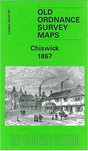
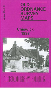
Chiswick 1867
Chiswick in 1867 in a fascinating series of reproductions of old Ordnance Survey plans in the Alan Godfrey Editions, ideal for anyone interested in the history of their neighbourhood or family. Three versions cover the area from Chiswick House and Christ Church (on Turnham Green) eastward to Hammersmith Bridge; and from High Road and King Street southward. Features include Chiswick Cemetery, Chiswick New Town, Devonshire Road, Duke Road, Griffin Brewery, St Nicholas church, West Middlesex Water Works, Royal Horticultural Gardens, Church Wharf, St Peter`s Square, The Creek. A portion of Hammersmith (south of King Street) is in the north-eastern corner. The Thames runs through the map, including Chiswick Eyot. Castlenau and Lonsdale Road are in the south-eastern quarter (except
in the 1935 version). Part of Turnham Green is in the north-west corner. A list of private residents in 1890 is included, split between the 1867 and 1893 maps. About the Alan Godfrey Editions of the 25” OS Series:Selected towns in Great Britain and Ireland are covered by maps showing the extent of urban development in the last decades of the 19th and early 20th century. The plans have been taken from the Ordnance Survey mapping and reprinted at about 15 inches to one mile (1:4, 340). On the reverse most maps have historical notes and many also include extracts from contemporary directories. Most maps cover about one mile (1.6kms) north/south, one and a half miles (2.4kms) across; adjoining sheets can be combined to provide wider coverage.FOR MORE INFORMATION AND A COMPLETE LIST OF ALL
AVAILABLE TITLES PLEASE CLICK ON THE SERIES LINK.

Product Description
Reviews/Comments
Add New
Intelligent Comparison
Archived Product
Chiswick 1893 Stanfords
£3.50
Vouchers
No voucher codes found.
Do you know a voucher code for this product or supplier? Add it to Insights for others to use.
Do you know a voucher code for this product or supplier? Add it to Insights for others to use.
 Denmark